- Crystal City, Arlington, Virginia
-
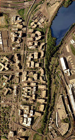
Crystal City — Unincorporated area — Crystal City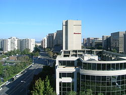 Satellite image of the interlocking highrises of Crystal City. Jefferson Davis Highway (U.S. 1) can be seen running from north to south left of the image center. The main terminal of National Airport is in the bottom right corner of the image; a few lanes of I-395 are visible in the top left corner, immediately beyond which is the Pentagon. At the bottom is State Route 233, the Airport Viaduct. Image from the United States Geological Survey, taken April 26, 2002.
Coordinates: 38°51′5.05″N 77°3′2.48″W / 38.8514028°N 77.0506889°WCoordinates: 38°51′5.05″N 77°3′2.48″W / 38.8514028°N 77.0506889°W Country United States State Virginia Population (2000) - Total 16,389 Time zone EST (UTC-5) - Summer (DST) EDT (UTC-4) ZIP Codes 22202 Area code(s) 703 Crystal City is an urban neighborhood in the southeastern corner of Arlington County, Virginia, south of downtown Washington, D.C.. Its residents can live, shop, and work without going outside, due to its extensive integration of office buildings and residential high-rise buildings using underground corridors. Thus, a large part of Crystal City is an underground city. It includes offices of numerous defense contractors, the United States Department of Labor, the United States Marshals Service, the EPA and many satellite offices for The Pentagon.
Contents
Location
Crystal City is centered along a stretch of Jefferson Davis Highway (U.S. 1), just south of The Pentagon, just east of Pentagon City, and within walking distance to the west of Ronald Reagan Washington National Airport. Characterized as one of many "urban villages" by Arlington County, Crystal City is almost exclusively populated by high-rise apartment buildings, corporate offices, hotels, and numerous shops and restaurants. There is also an extensive network of underground shopping areas and connecting corridors beneath Crystal City.
Crystal City has a station on the Washington Metro Blue and Yellow Lines, and another on the Virginia Railway Express commuter train system.
History
Prior to development by the Charles E. Smith Co., the area was mostly composed of industrial sites, junkyards, and low rent motels. The RF & P railroad tracks were also moved closer to National Airport to accommodate more space for development.
Though it is not actually a planned community, it unfolded in much that fashion after construction began on the first few condominiums and office buildings in 1963. The name "Crystal City" came from the first building, which was called Crystal House and had an elaborate crystal chandelier in the lobby. Every subsequent building took on the Crystal name (i.e., Crystal Gateway, Crystal Towers), and eventually the whole neighborhood. Crystal City is largely integrated in layout and extensive landscaping, as well as the style and materials of the high rise buildings, most of which have a speckled granite exterior.
Crystal City's Crystal Underground shopping mall opened in September 1976. Billed as a "turn-of-the-century shopping village," it featured antique leaded glass shop windows and cobblestone "streets." Emphasis was on locally owned and operated businesses and personalized service. The largest retail outlets were a 12,000-square-foot (1,100 m2) Jelleff's women's store, Larimers gourmet grocery and delicatessen, and a Drug Fair. The mall also featured an "Antique Alley" with small antique and craft stores. At opening there were 40 stores, with an anticipated expansion of 150,000 square feet (14,000 m2) with 70 more shops including the Crystal Palace food court.[1]
On June 26, 2004, the Crystal City area underwent a number of changes. Many buildings' addresses were changed on this date, several major roads were turned into two-way streets, and many of the markings for the traditional building names (e.g., "Crystal Gateway 1") were removed. As a result, local residents may refer to building names that are difficult for visitors to find.[2]
Layout
The layout of Crystal City was considered avant-garde at the time of construction, with superblocks bounded by arterial and circulating roads, and with pedestrian traffic and the businesses serving it relocated from the streets to the pedestrian tunnels. However, Crystal City has been redesigned to give it a more traditional, urban feel, with restaurants at street level, and with traffic patterns changed to make streets like Crystal Drive function as city streets, rather than as circulating roads.[3]
As a consequence of Crystal City's extensive integration with both office buildings and residential high-rise buildings, it is possible for most residents living to the east of Route 1 to traverse from one end to the other (roughly north-south), performing any shopping or dining along the way, entirely underground, thus making a large part of Crystal City an underground city. This is of particular importance during inclement weather.
Economy
Crystal City presently has over 6,000 residents, while around 60,000 come to work there every weekday.[4] It was home to the United States Patent and Trademark Office until mid-2005, when the PTO moved to nearby Alexandria. It also has offices of numerous defense contractors, the United States Department of Labor, the EPA and many satellite offices for The Pentagon, which is currently being renovated.[5]
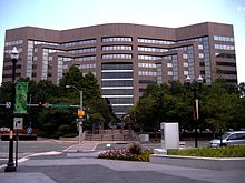 Crystal Park Four, former headquarters in Crystal City, Arlington County.
At one time US Airways had its headquarters in Crystal Park Four in Crystal City.[6] After US Airways merged with America West Airlines in 2005, the combined company closed the Virginia headquarters and moved the management to Tempe, Arizona.[7]
References
- ^ "Crystal Underground opens," by Pat Royse, The Washington Post, Sep 30, 1976, p. VA_14.
- ^ David A. Wheeler. "Crystal City Name Changes (Address Changes)". http://www.dwheeler.com/essays/crystal-city.html. Retrieved 2010-11-01.
- ^ "Envisioning Crystal City as part of a larger community". Greater Greater Washington. 2009-05-14. http://greatergreaterwashington.org/post.cgi?id=2565. Retrieved 2009-10-26.
- ^ Linda Wheeler (1995-03-25). "Crystal City: Model of Convenience". Washington Post. http://www.washingtonpost.com/wp-srv/local/counties/arlngton/longterm/wwlive/crystal.htm. Retrieved 2009-10-26.
- ^ By E.L. Wasson (2007-12-01). "Washington, D.C.: Threatened Crystal City closures appear derailed | The Real Deal | New York Real Estate News". Ny.therealdeal.com. http://ny.therealdeal.com/articles/washington-dc-threatened-crystal-city-closures-appear-derailed-2. Retrieved 2009-07-16.
- ^ "THE FOLLOWING LETTER WAS SENT TO THE ATTACHED LIST OF U.S. & FOREIGN AIRLINE, and TRAVEL AGENCY EXECUTIVES." U.S. Department of Transportation. July 14, 1995. Retrieved on March 1, 2010.
- ^ "US Airways to move headquarters to Tempe, Ariz., early in 2006." The Tribune. July 23, 2005. Retrieved on March 1, 2010.
Further reading
- Silverman, Elissa (2005-06-06). "Crystal City Attempts to Change for The Better". The Washington Post: pp. D01. http://www.washingtonpost.com/wp-dyn/content/article/2005/06/05/AR2005060501108.html?nav=rss_business. Retrieved 2009-03-24.
External links
Municipalities and communities of Arlington County, Virginia County seat: Arlington Unincorporated
communitiesArlington Ridge | Ballston | Cherrydale | Clarendon | Courthouse | Crystal City | Fairlington | Glencarlyn | Lyon Village | Pentagon City | Rosslyn | Shirlington | Virginia Square | Westover
 Categories:
- Neighborhoods in Arlington County, Virginia
- Underground cities
- Transit-oriented developments


Wikimedia Foundation. 2010.