Mratinje Dam

Mratinje Dam
Mratinje Dam
Mratinje Dam is located in Montenegro
{{{alt}}}
Location of Mratinje Dam
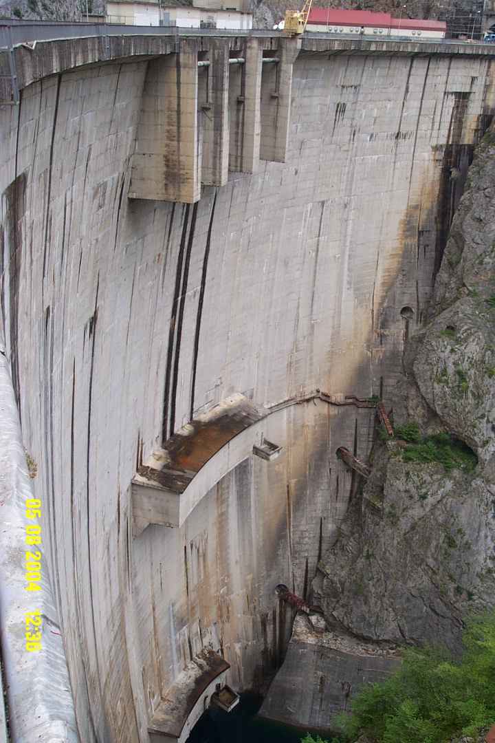
Country Montenegro
Coordinates 43°16′20″N 18°50′30″E / 43.27222°N 18.84167°E / 43.27222; 18.84167Coordinates: 43°16′20″N 18°50′30″E / 43.27222°N 18.84167°E / 43.27222; 18.84167
Status In use
Construction began 1971
Opening date 1976
Owner(s) Electric Power Authority of Montenegro
Dam and spillways
Type of dam Arch, double-curvature
Height 220 m (722 ft)
Length 268 m (879 ft)
Crest width 4.5 m (15 ft)
Base width 45 m (148 ft)
Volume 732,940 m3 (25,883,532 cu ft)
Impounds Piva River
Reservoir
Creates Piva Lake
Capacity 880,000,000 m3 (710,000 acre·ft)
Catchment area 1,757.7 km2 (679 sq mi)
Surface area 12 km2 (5 sq mi)
Power station
Turbines 3 x 120 MW
Installed capacity 360 MW

The Mratinje Dam is a concrete arch dam in the canyon of the Piva River in Montenegro.

The dam was completed in 1975 with designs by Energoprojekt.[1] Its construction resulted in the flooding of the Piva canyon and the creation of Lake Piva, which, with its 12.5 km², is the second largest lake in Montenegro.

The dam is 220 metres (720 ft) high, one of the highest in Europe. The dam is 268 metres (879 ft) long and 4.5 metres (15 ft) thick at the crest, while it is 30 metres (98 ft) long and 36 metres (118 ft) thick at the base. The foundations go as deep as 38 metres (125 ft) into the ground. 820,000 cubic metres (1,070,000 cu yd) of concrete and 5,000 tonnes of steel were built into the dam.[2]

The hydroelectric power station at Mratinje is capable of producing 860 gigawatt-hours per annum. It has three turbines and generators, each with a generation capacity of 120 MW.

The location of the 16th century Piva Monastery was flooded by the lake, so while the dam was built, the monastery was broken into pieces and moved to a higher ground, 3.5 km away. It was reconstructed in the original way.

References

  1. ^ "Mratinje Dam and Hydroelectric Plant". Energoprojekt. http://eng.energoprojekt.rs/index.php?pageid=73. Retrieved 6 May 2011. 
  2. ^ Marković, Veljko; Svetlana Živković, Jelena Marković (1999). "Global Elastic Modulus Usage for Diagnosing the Mratinje Dam Behavior". Facta Universitatis. Architecture and Civil Engineering (University of Niš) 2 (1): 67–75. http://facta.junis.ni.ac.rs/aace/aace99/aace99-09.pdf. Retrieved 6 May 2011. 

Wikimedia Foundation. 2010.

Игры ⚽ Поможем написать курсовую

Look at other dictionaries:

  • Mratinje-Talsperre — Staumauer …   Deutsch Wikipedia

  • Arch-gravity dam — Arch gravity Hoover Dam Architectural Plans An arch gravity dam, curved gravity dam or arched dam is a dam with the characteristics of both an arch dam and a gravity dam. It is a dam that curves upstream in a narrowing curve that directs most of… …   Wikipedia

  • Список самых высоких плотин в мире — Естественная плотина высотой 567 м на реке Мургаб и Сарезское озеро (Таджикистан) …   Википедия

  • Observation deck — The 1793 Puente Nuevo bridge allows viewing from 120 m above the floor of El Tajo canyon. Main article: Deck (building) For other uses, see Deck …   Wikipedia

  • List of tallest buildings and structures in the world by country — This is a list of the tallest buildings and structures by country. The list directly includes the tallest buildings and structures for each country, and where appropriate, it also points to more detailed country specific… …   Wikipedia

  • Plužine — Infobox Montenegro city name=Plužine city name cyr=Плужине mayor=Mijuško Bajagić (SNP DSS) area=854 population=1,494 municipality=4,272 Time zone=UTC+1 founded=14th Century latitude=43.15 longitude=18.83 area code=83 car plates=NK postal=81435… …   Wikipedia

  • Liste der Talsperren der Welt — In dieser Liste sollen alle größeren bzw. bedeutenden Talsperren der Erde länderweise und alphabetisch sortiert aufgeführt werden. Wenn bezüglich ihrer Auflistung deren Anzahl für ein Land zu groß wird, kann die Liste für dieses Land… …   Deutsch Wikipedia

  • Liste von Talsperren der Welt — In dieser Liste sollen alle größeren bzw. bedeutenden Talsperren der Erde länderweise und alphabetisch sortiert aufgeführt werden. Wenn bezüglich ihrer Auflistung deren Anzahl für ein Land zu groß wird, kann die Liste für dieses Land… …   Deutsch Wikipedia

  • Liste der größten Talsperren der Erde — Die Liste der größten Talsperren der Erde zeigt einer Auswahl der höchsten und längsten Talsperren (das heißt der Absperrbauwerke, nicht zu verwechseln mit Stausee) der Erde und im deutschsprachigen Raum. Sie umfasst alle Bauarten (Staumauern,… …   Deutsch Wikipedia

  • Piva River — The Piva (Serbian Cyrillic: Пива) is the river in Montenegro, shorter headwater of the Drina river, which it forms with the Tara river on the border with Bosnia and Herzegovina. Course The Piva springs from the Sinjac (Cyrillic: Сињац ) spring on …   Wikipedia

Share the article and excerpts

Direct link
Do a right-click on the link above
and select “Copy Link”