Coalsnaughton

Coalsnaughton
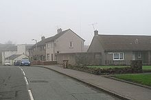
A wintry day in the suburbs of Coalsnaughton, February 2008

Coalsnaughton or Calibar (Scottish Gaelic: Caolas Neachdainn) is a village in Clackmannanshire, Scotland. It is just south of Tillicoultry. a small town which is based upon a slope facing down towards Tillicoultry which creates a valley between Coalsnaughton and the Ochil Hills. There are great sights from Coalsnaughton.

The war memorial is by the Scots sculptor George Henry Paulin.

It also has 2 shops one of which includes a post office. As well as this it has a takeaway and one of the favourite local haunts is the Burns Club based around the great Scottish Tradition of celebrating the great life works of Robert Burns or "Rabbie Burns".

Geographically Coalsnaughton is well placed and links to the Dam lone, Gartmorn Dam, Dollar and Fishcross by means of some fairly dangerous A roads. Coalsnaughton also boasts its own Primary School. It leads onto to Devonside by the Crankie Brae and the Glen which has recently had a number of new builds attached to the land just up from Langower which leads onto Devonside and Drummie Road and then towards Sterling Mills and then into Moss Road in Tillicoultry.

Coordinates: 56°08′30″N 3°44′23″W / 56.1417°N 3.7396°W / 56.1417; -3.7396


Wikimedia Foundation. 2010.

Игры ⚽ Поможем решить контрольную работу

Look at other dictionaries:

  • Coalsnaughton —    COALSNAUGHTON, a village, in the parish of Tillicoultry, county of Clackmannan, 3 miles (N. E.) from Alloa; containing 691 inhabitants. It lies on the road to Stirling, not far from the river Devon, and is inhabited chiefly by colliers …   A Topographical dictionary of Scotland

  • Tillicoultry —    TILLICOULTRY, a parish, in the county of Clackmannan; containing, with the villages of Coalsnaughton and Devonside, 3560 inhabitants, of whom 2300 are in the village of Tillicoultry, 4 miles (N. E. by N.) from Alloa. The name of this place is… …   A Topographical dictionary of Scotland

  • Clackmannanshire — Siorrachd Chlach Mhannainn …   Wikipedia

  • Alva Academy — Infobox UK school name = Alva Academy size = 125px latitude = longitude = dms = motto = Acer in ludo ludisque motto pl = established = 1860s approx = closed = c approx = type = religion = president = head label = Headteacher head = John Meney r… …   Wikipedia

  • Clackmannan — Coordinates: 56°06′33″N 3°44′47″W / 56.109097°N 3.7465196°W / 56.109097; 3.7465196 …   Wikipedia

  • Tillicoultry — infobox UK place country = Scotland official name= Tillicoultry population= 5221 os grid reference= NS9180696986 map type= Scotland latitude=56.153333 longitude= 3.741944 gaelic name= Tulach Cultaire scots name= Tillicoultry, Tilly unitary… …   Wikipedia

  • Dollar, Clackmannanshire — Coordinates: 56°09′45″N 3°40′05″W / 56.16249°N 3.66814°W / 56.16249; 3.66814 …   Wikipedia

  • Menstrie — Coordinates: 56°09′03″N 3°51′16″W / 56.15085°N 3.85438°W / 56.15085; 3.85438 …   Wikipedia

  • Muckhart — Coordinates: 56°11′18″N 3°36′41″W / 56.18841°N 3.61125°W / 56.18841; 3.61125 …   Wikipedia

  • List of state schools in Scotland/Council Areas A-D (excluding cities) — The following is a partial list of currently operating state schools in the unitary council areas of Aberdeenshire, Angus, Argyll and Bute, Clackmannanshire and Dumfries and Galloway in Scotland, United Kingdom. You may also find of use to find a …   Wikipedia

Share the article and excerpts

Direct link
Do a right-click on the link above
and select “Copy Link”