- Uranquinty, New South Wales
Infobox Australian Place
type = town
name = Uranquinty
state =New South Wales
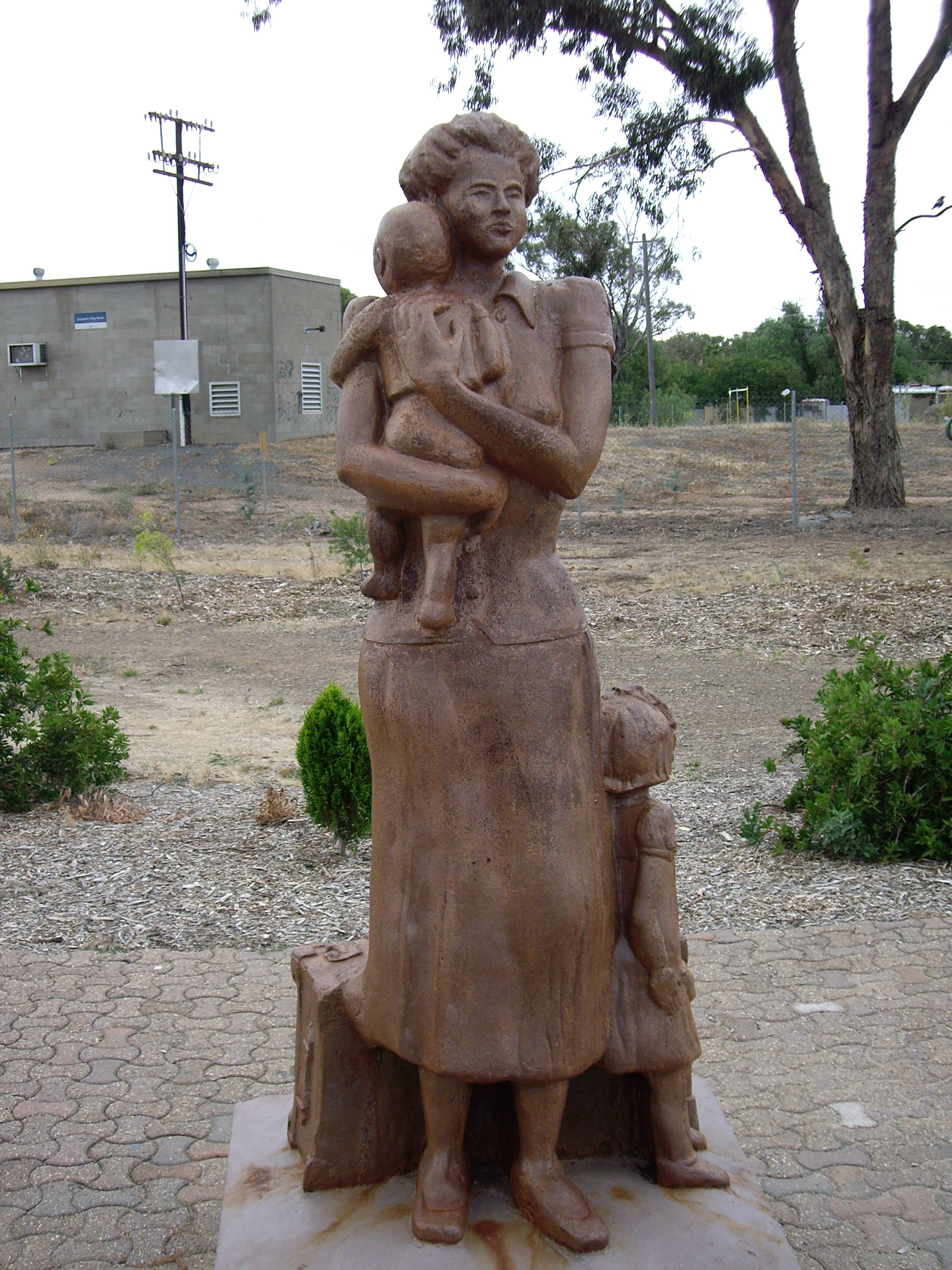
caption = Uranquinty memorial to the Wives and Children of Refugees who worked on the Snowy Mountain Scheme
lga=City of Wagga Wagga
parish = Uranquinty
county = Mitchell
stategov = Wagga Wagga
fedgov = Riverina
postcode = 2652
pop = 641 (2001 Census) [Census 2001 AUS|id=UCL178400|name=Uranquinty (L) (Urban Centre/Locality)|accessdate=2007-06-30|quick=on]
est =
dist1 = 15
location1 =Wagga Wagga Uranquinty is a small town approximately 15 km south of Wagga Wagga in the
Riverina region ofNew South Wales ,Australia . The population of the town is 641.Uranquinty was used as the railway village when the railway line was being built from Wagga Wagga to Albury.
Uranquinty during World War II
Uranquinty has a distinguished record in relation to
World War II . At the end of 1940 Uranquinty was chosen as the 5th Service Flying School (5 SFTS) for intermediate and advanced training of Empire Air Trainees. The site chosen for 5 SFTS was especially suitable because it was on the mainSydney toMelbourne railway line and comprised just over 1000acres (4 km²) of land that was owned by the Lewington family. Possession of this land was taken under National Security (General) Regulation 54 which existed during the War years [ Details of these facts are displayed on a number of elaborate information boards that currently exist (2007) at the Uranquinty roadsidebarbecue area in the centre of the town. ]Uranquinty Migrant Centre
The Uranquinty Migrant Centre was established as a result of the Displaced Persons Immigration Scheme that had been embarked upon by
Prime Minister Chifley's government at the end of the Second World War as was a part of the "Populate or Perish" catchcry of the times.Under
Arthur Calwell , Australia's first Minister for Immigration, displaced persons still in camps withinGermany ,Austria andFrance were chosen to fill the need for a constant supply of labour to the country. Reception and training centres were established in now disused army and RAAF camps in rural and remote areas such as Uranquinty from 1948, particularly because by then married displaced persons with their families were being allowed entry into Australia. Places like Uranquinty had the space to provide accommodation for the wives and children. Many of these displaced persons worked on the relatively nearbySnowy Mountains Scheme .One such family that arrived were the
Latvia n-born Konrads family, two of whom would learn to swim in Uranquinty because their father was afraid they might drown in the numerous dams and creeks in the area. Those two, John andIlsa Konrads , would set between them 38 individual world records and go on to become Olympic medalists for their adopted country.A public memorial in the centre of Uranquinty, situated directly on the Olympic Highway, displays information boards and other memorials to the history of displaced persons who stayed in the area during these years.
Uranquinty today
Construction of the $500 million gas fired power station at Uranquinty is planned to be completed during 2008.
Transport
Uranquinty is located on the Sydney to
Melbourne railway line. The station is still listed as "in use", but no passenger trains stop there, even by special request. [ [http://www.nswrail.net/locations/show.php?name=NSW:Uranquinty&line=NSW:main_south:0 Uranquinty Railway Station] [http://www.countrylink.info/timetables/southern/melbourne_to Countrylink Timetable, showing that no stop is possible for passengers at Uranquinty, even by request.] ]Notes and References
Wikimedia Foundation. 2010.