- Dysart et al, Ontario
-
Dysart et al — United Township — Corporation of the United Townships of Dysart, Dudley, Harcourt, Guilford, Harburn, Bruton, Havelock, Eyre and Clyde 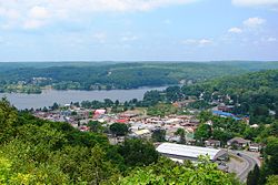
Motto: Confidently yet cautiously 
 Dysart et al
Coordinates: 45°12′N 78°25′W / 45.2°N 78.417°WCoordinates: 45°12′N 78°25′W / 45.2°N 78.417°W Country  Canada
Province  Ontario
County Haliburton Settled 1860s Incorporated January 7, 1867 Government – Type Township – Reeve Murray Fearrey – Federal riding Haliburton—Kawartha Lakes—Brock – Prov. riding Haliburton—Kawartha Lakes—Brock Area[1] – Land 1,474.07 km2 (569.1 sq mi) Population (2006)[1] – Total 5,526 – Density 3.7/km2 (9.6/sq mi) Time zone EST (UTC-5) – Summer (DST) EDT (UTC-4) Postal Code K0M Area code(s) 705, 249 Website www.dysartetal.ca The United Townships of Dysart, Dudley, Harcourt, Guilford, Harburn, Bruton, Havelock, Eyre and Clyde (shortened to Municipality of Dysart et al meaning Municipality of Dysart and others) is a municipality in Haliburton County in Central Ontario, Canada.[2][3] The original townships were of the Canadian Land and Emigration Company.
Contents
Communities
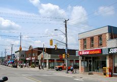 Haliburton's main street
The municipality's primary town is Haliburton (45°02′50″N 78°30′30″W / 45.04722°N 78.50833°W), a community on Head Lake. Haliburton has a seasonal tourism-based economy. Some of southern Ontario's population retreats to central and northern Ontario "cottage country" for recreation and relaxation during the summer.
Haliburton Village and Haliburton County derive their name from the author Thomas Chandler Haliburton, who wrote the popular "Sam Slick" stories in the mid-19th century. Haliburton was chairman of the Board of Directors of The British Land and Immigration Company in England, who were responsible for developing most of the area before it became incorporated into a "Provisional County" in 1887.
The municipality also includes the smaller communities of Donald, Eagle Lake, Fort Irwin, Goulds, Harburn, Kennaway (ghost town),[4][5] Kennisis Lake and West Guilford.
History
In the 1860s, the Canadian Land and Emigration Company of London, England purchased 360,000 acres (150,000 ha) in this part of Ontario for settlement purposes. The development was named after company chairman Judge Thomas Haliburton, a politician and the author of the Sam Slick stories.[6][7] According to the book "Fragments of a Dream", the first European settlers began arriving in Haliburton village in 1864. Key settlers included Captain John Lucas (1824-1874). Lucas co-established the first saw/grist mill and was later elected the first Reeve of Dysart. Captain Lucas, originally a native of Long Preston, Yorkshire, England, also established the first hotel in town that later became the Grand Central Hotel. Other important settlers included W. Ritchie, Alexander Niven, James Holland, John Erskine, the Heard family and Willet Austin.
Haliburton was the northern terminus of the Victoria Railway (ex Canadian National Railway Haliburton subdivision) from Lindsay.[8][9] The first railway train to arrive in Haliburton was on November 26, 1878 with John Albert Lucas (1860-1945) as the train engineer. The railway was abandoned and the rails lifted in 1980. The station remains and is now home to Rails End Gallery and Arts Centre.
Fire tower history
The former Dysart fire tower was erected in 1956 on a hill by the east side of the village just off of Ontario Highway 118. Its 100-foot (30 m) frame still stands, but the cupola has since been removed. It was erected by Ontario's former Department of Lands and Forests (now the Ministry of Natural Resources) as an early detection to protect the local forests from fire. This tower was put out of use in the late 1960s when aerial detection systems were put in place. It was one of the County of Haliburton's many towers that were part of the former Lindsay Forest Fire District. Other towers included: Harburn, Eyre, Glamorgan (Green's Mountain), Harvey, Cardiff, Digby, Lutterworth, Sherboure (St. Nora), Dorset and Bruton. There were Department of Lands and Forests offices stationed in Minden, Ontario, Dorset and at St. Nora Lake (now the Leslie Frost Centre).
Education
The County of Haliburton is part of the Trillium Lakelands District School Board.
Elementary:
- Stuart W. Baker Elementary School (French Immersion): Grades K–4
- J. Douglas Hodgson Elementary School: Grades 4–8
Secondary:
- Haliburton Highlands Secondary School
Post-Secondary:
Adult Education:
- Highlands Adult Education and Training Centre
- Fleming College Academic Upgrading
Demographics
According to the 2006 Statistics Canada Census:[1]
- Population: 5,526
- % Change (2001–2006): 12.2
- Area (km².): 1,474.07
- Density (persons per km²): 3.7
- Private dwellings occupied by usual residents: 2345 (total dwellings: 6861)
- Mother tongue:
- English as first language: 95.1 %
- French as first language: 1.0 %
- English and French as first language: 0.2 %
- Other as first language: 3.7 %
Population trend:[10]
- Population in 2006: 5526 (2001 to 2006 population change: 12.2 %)
- Population in 2001: 4924
- Population in 1996: 5380
- Population in 1991: 4856
Culture
Dysart et al has a vibrant cultural community including Haliburton School of The Arts, Highlands Summer Theatre, Highlands Opera Studio, Haliburton Highlands Museum, Haliburton Sculpture Forest and Rails End Gallery and Arts Centre.
Haliburton Internation Film Festival (HIFF) is held each November at the Northern Lights Performing Arts Centre at the high school.
The Annual Haliburton Art and Craft Festival is held on the fourth weekend in July and is a signature event for Haliburton County with attendance of approx 7500 and over 100 artisans.
Haliburton appears as a significant setting in Canadian literature. Examples include Richard Pope's Me n Len - Life in the Haliburton Bush 1900–1940 and Robert Rotenberg's Old City Hall.
Scenes from the movie Meatballs (1979)[11] were filmed at Camp White Pine, Haliburton.
Parks
Southern portions of Algonquin Provincial Park lie in Dysart et al in the geographic townships of Bruton, Clyde, Eyre and Harburn.[12]
Notable people
- Matt Duchene - Drafted 3rd overall in the 2009 National Hockey League Entry Draft by the Colorado Avalanche. Was third in Calder Trophy voting after the 2009-10 season, behind Tyler Myers of the Buffalo Sabres and Jimmy Howard of the Detroit Red Wings.
- Cody Hodgson - OHL Hockey player for the Brampton Battalion, selected 10th overall by the Vancouver Canucks in the 2008 National Hockey League Entry Draft, grew up in Haliburton
- Howie Lockhart - Born April 22, 1897, in North Bay, Ontario, Canada. Was a Canadian professional ice hockey goaltender who played 5 seasons in the National Hockey League for the Toronto St. Pats, Quebec Bulldogs, Hamilton Tigers and Boston Bruins. Lockhart was a resident of Haliburton and died there on August 2, 1956.
- Bernie Nicholls - From West Guilford, Nicholls played 18 seasons in the National Hockey League with the Los Angeles Kings, New York Rangers, Edmonton Oilers, New Jersey Devils, Chicago Blackhawks and San Jose Sharks.
- Ron Stackhouse - From Haliburton, Stackhouse played 12 seasons in the National Hockey League with the California Golden Seals, Detroit Red Wings and Pittsburgh Penguins. The local arena has mural paintings of Stackhouse and Nicholls on the outside wall.
References
- ^ a b c Statistics Canada 2006 Census - Dysart and Others community profile
- ^ "Dysart, Dudley, Harcourt, Guilford, Harburn, Bruton, Havelock, Eyre and Clyde". Geographical Names Data Base. Natural Resources Canada. http://geonames.nrcan.gc.ca/search/unique_e.php?id=FELOV&output=xml. Retrieved 2011-11-11.
- ^ "Dysart, Dudley, Harcourt, Guilford, Harburn, Bruton, Havelock, Eyre and Clyde". Atlas of Canada. Natural Resources Canada. 2010-02-04. http://atlas.nrcan.gc.ca/site/english/maps/topo/map?mapsize=750%20666&mapxy=1310057.40945%20-253532.554688&scale=500000&feature_na=Dysart%2C%20Dudley%2C+Harcourt%2C+Guilford%2C+Harburn%2C+Bruton%2C+Havelock%2C+Eyre+and+Clyde&searchstring=Dysart%2C%20Dudley%2C%20Harcourt%2C%20Guilford%2C%20Harburn%2C%20Bruton%2C%20Havelock%2C%20Eyre%20and%20Clyde&layers=fapfeature%20fapfeature%20north_arrow%20other_features%20million_grid%20t50k_grid%20grid_50k_3%20roads%20hydrography%20boundary%20builtup%20vegetation%20populated_places%20railway%20power_network%20manmade_features%20designated_areas%20water_features%20water_saturated_soils%20relief%20contours%20toponymy%20contour%20nodata_ntdb_50k&map_layer%5bnortharrow%5d_class%5b0%5d_style%5b0%5d=ANGLE%20-15.073153558506107&urlappend=%26unique_key%3D0d0b079e849c20c31c49551b2f94f533%26map.layer%5Btextzoom03%5D%3DFEATURE+POINTS+1310706.1211+-254503.486818+END+TEXT+%22Dysart%252C+Dudley%252C+Harcourt%252C+Guilford%252C+Harburn%252C+Bruton%252C+Havelock%252C+Eyre+and+Clyde%22+END%26map.layer%5Btextzoom46%5D%3DFEATURE+POINTS+1310706.1211+-254503.486818+END+TEXT+%22Dysart%252C+Dudley%252C+Harcourt%252C+Guilford%252C+Harburn%252C+Bruton%252C+Havelock%252C+Eyre+and+Clyde%22+END%26map.layer%5Bpolygonresultzoom0%5D%3DDATA+csd01_1m_r%26map.layer%5Bpolygonresultzoom1%5D%3DDATA+csd01_1m_r%26map.layer%5Bpolygonresultzoom2%5D%3DDATA+csd01_1m_r%26map.layer%5Bpolygonresultzoom0outline%5D%3DDATA+csd01_1m_r%26map.layer%5Bpolygonresultzoom1outline%5D%3DDATA+csd01_1m_r%26map.layer%5Bpolygonresultzoom2outline%5D%3DDATA+csd01_1m_r%26map.layer%5Barrowzoom03%5D%3DFEATURE+POINTS+1310706.1211+-254503.486818+END+END. Retrieved 2011-11-11. Shows the area of the municipality highlighted on a map.
- ^ Martinello, Christopher (1998). "Welcome to Old Kennaway". Topics in material culture. University of Toronto, Department of History. http://www.history.utoronto.ca/material_culture/cmartine/. Retrieved 2011-11-09.
- ^ "Kennaway". Geographical Names Data Base. Natural Resources Canada. http://geonames.nrcan.gc.ca/search/unique_e.php?id=FBTWS&output=xml. Retrieved 2011-11-09.
- ^ "Founding of Haliburton, The". Online Plaque Guide. Ontario Heritage Trust. http://www.heritagetrust.on.ca/Resources---Learning/Online-Plaque-Guide/Plaque-Information.aspx?searchtext=2. Retrieved 2011-11-11.
- ^ "Founding of Haliburton". Ontario's Historical Plaques. http://www.ontarioplaques.com/Plaques_GHI/Plaque_Haliburton03.html. Retrieved 2011-11-11.
- ^ "Victoria Railway, The". Online Plaque Guide. Ontario Heritage Trust. http://www.heritagetrust.on.ca/Resources---Learning/Online-Plaque-Guide/Plaque-Information.aspx?searchtext=4. Retrieved 2011-11-11.
- ^ "The Victoria Railway". Ontario's Historical Plaques. http://www.ontarioplaques.com/Plaques_GHI/Plaque_Haliburton04.html. Retrieved 2011-11-11.
- ^ Statistics Canada: 1996, 2001, 2006 census
- ^ Meatballs. http://en.wikipedia.org/wiki/Meatballs_(film).
- ^ McMurtrie, Jeffrey (2008). "Algonquin Provincial Park and the Haliburton Highlands". Wikimedia Commons. http://commons.wikimedia.org/wiki/File:Algonquin_Map_2008_-_Version_1.0_-_Smaller_rs.jpg. Retrieved 2010-07-28.
- Dobrzensky, Leopolda (1985). Fragments of a Dream: Pioneering in Dysart Township and Haliburton Village. Municipality of Dysart. ISBN 9780969234807. OCLC 13861930.
- Ballantine, Thomas; Hill, Stephen (2008). Haliburton: A History In Pictures. Haliburton Highlands Museum. ISBN 9780969648024. OCLC 503058634.
External links

Algonquin Highlands Algonquin Highlands 
South Algonquin
Hastings Highlands Dysart et al

Minden Hills Highlands East Categories:- Municipalities in Haliburton County, Ontario
- Township municipalities in Ontario


Wikimedia Foundation. 2010.