- New River (Kanawha River)
-
New River River  The New River within the New River Gorge, as viewed from Hawks Nest State Park in West Virginia.
Country United States States North Carolina, Virginia, West Virginia Counties Ashe NC, Alleghany NC, Grayson VA, Carroll VA, Wythe VA, Pulaski VA, Montgomery VA, Giles VA, Mercer WV, Summers WV, Raleigh WV, Fayette WV Tributaries - left Bluestone River, East River - right Little River, Indian Creek, Greenbrier River Source South Fork New River [1] - location Boone, NC - elevation 3,104 ft (946 m) - coordinates 36°12′16″N 81°38′59″W / 36.20444°N 81.64972°W Secondary source North Fork New River [2] - location Elk Knob, Watauga County, NC - elevation 4,446 ft (1,355 m) - coordinates 36°19′59″N 81°41′04″W / 36.33306°N 81.68444°W Source confluence - location Ashe County, NC - elevation 2,546 ft (776 m) - coordinates 36°32′45″N 81°21′09″W / 36.54583°N 81.3525°W Mouth Kanawha River [3] - location Gauley Bridge, WV - elevation 653 ft (199 m) - coordinates 38°09′42″N 81°11′47″W / 38.16167°N 81.19639°W Length 320 mi (515 km) Discharge for Thurmond, WV, max and min at Glen Lyn, VA - average 8,730 cu ft/s (247 m3/s) [4][5][6] - max 226,000 cu ft/s (6,400 m3/s) - min 538 cu ft/s (15 m3/s)  Map of the Kanawha River watershed, with the New River and its watershed highlighted.
The New River, part of the Ohio River watershed, is a tributary of the Kanawha River about 320 mi (515 km) long. The river flows through the U.S. states of North Carolina, Virginia, and West Virginia. Much of the river's course through West Virginia is designated as the New River Gorge National River, and the New River is one of the nation's American Heritage Rivers.
Named the New River because it was not known to early Atlantic Coast explorers,[citation needed] the New River is the southernmost river in North America that flows from south to north.[7] Despite its name, the New River is the second oldest river in the world geologically,[7] and the only nontidal river[8] that crosses the Appalachian Mountains.
This ancient river begins in the mountains of North Carolina near the Tennessee state line, flows generally northwestward across the Blue Ridge Mountains, Great Appalachian Valley, Ridge and Valley Province, and the Allegheny Front in western Virginia and West Virginia, then cuts through the Appalachian Plateau (in the New River Gorge) to meet the Gauley River and become the Kanawha River in south-central West Virginia.[7] The Kanawha then flows to the Gulf of Mexico via the Ohio and Mississippi rivers. Much of the river's course is lined with steep cliffs and rock outcrops, particularly in its gorge in West Virginia.[7][9]
This low-level crossing of the Appalachians, many millions of years old, has long been a biogeograpical corridor allowing numerous species of plants and animals to spread between the lowlands of the American East Coast and those of the Midwest; other unusual kinds of plants occur on the gorge's cliffs or rim-top ledges.[9] Portions of this corridor are now also used by various railroads and highways, and some segments of the river have been dammed for hydroelectric power production.
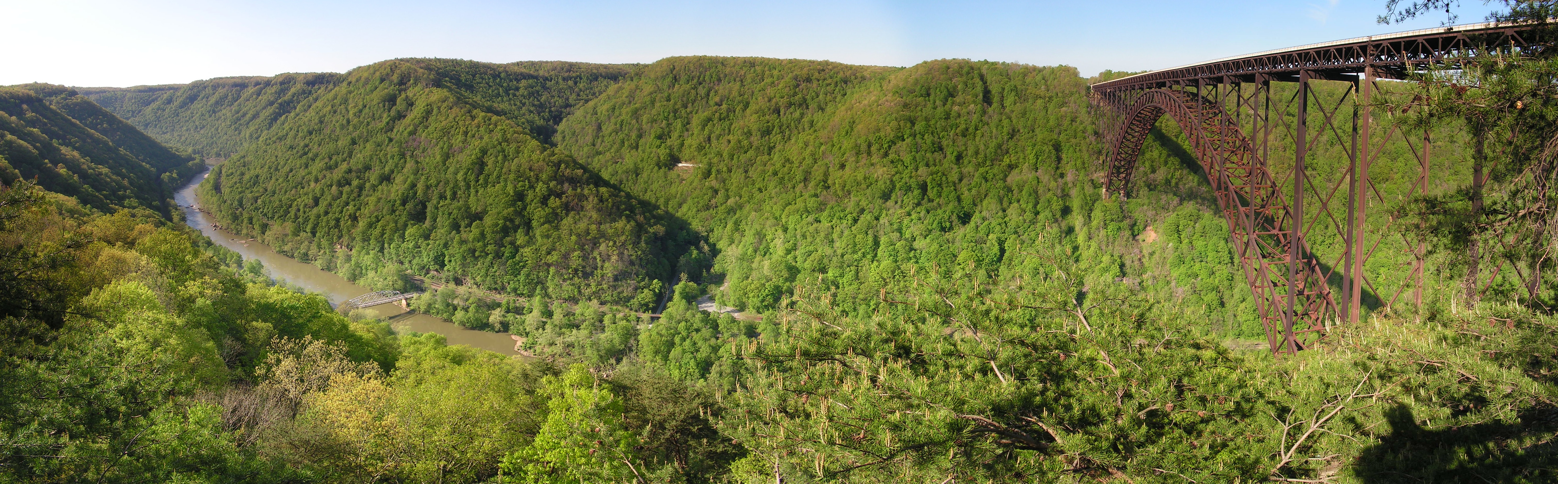
The New River Gorge is not only quite scenic, but also offers numerous opportunities for white-water recreation such as rafting and kayaking. Many open ledges along the rim of the gorge offer popular views, with favorites including Hawks Nest State Park and various overlooks on lands of the New River Gorge National River.
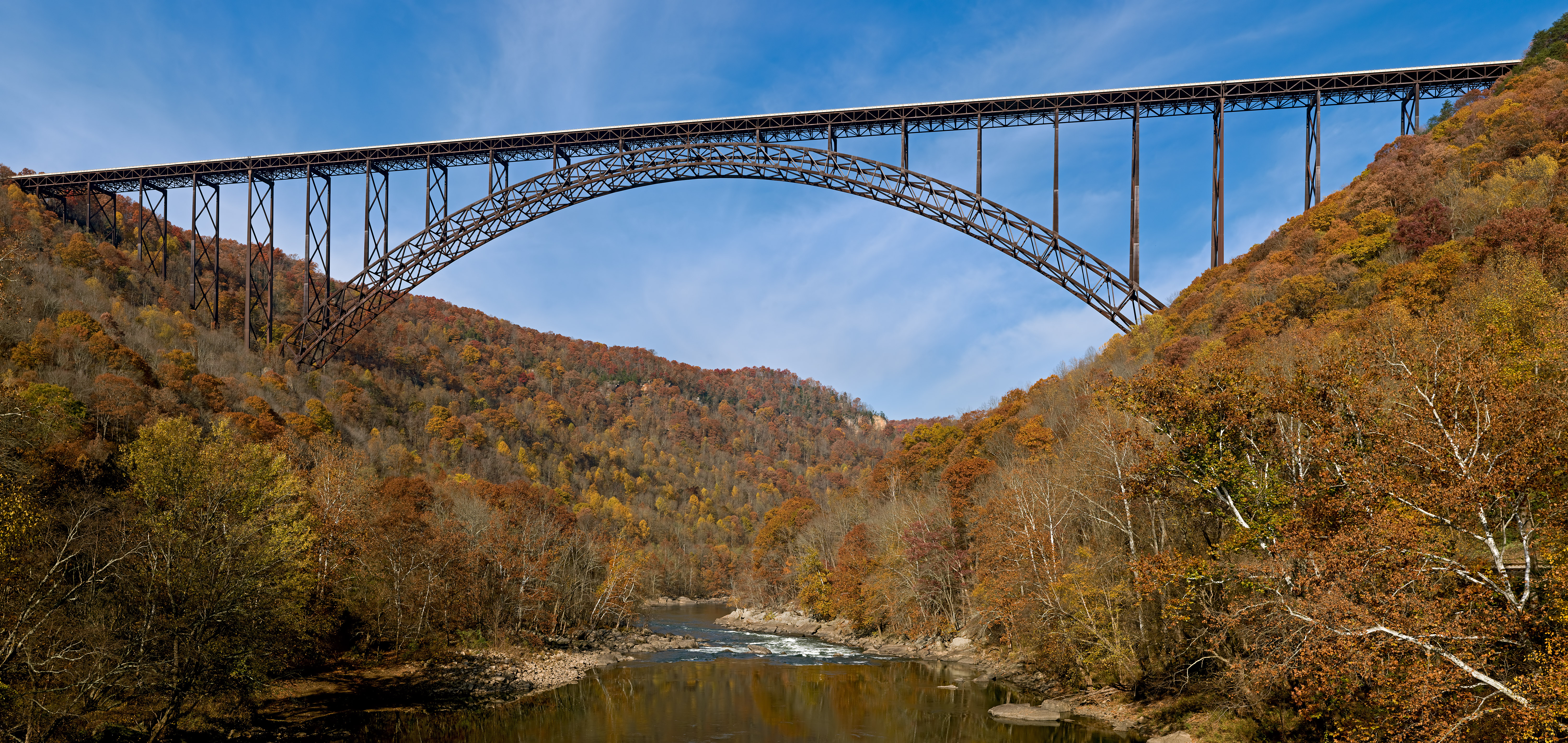
 The New River Gorge Bridge on U.S. 19 in West Virginia.
Few highways cross the gorge, with the most dramatic bridge by far being the New River Gorge Bridge on U.S. 19, a steel arch bridge spanning 1,700 feet (518 m), with the roadway 876 feet (267 m) above the river. This structure is the third-longest arch bridge in the world, and is also the world's fifth-highest vehicular[10] bridge, and the second highest in the Americas.
In North Carolina, a segment of the river 26.5 miles (42.6 km) long was designated as the "New River State Scenic River" and included in the state's Natural and Scenic Rivers System in 1975.[11][12] This segment was then included in the National Wild and Scenic Rivers System in 1976.
The New River Gorge and the U.S. 19 bridge crossing it are shown on the West Virginia State Quarter, minted in 2005.
Contents
Course
The New River is formed by the confluence of the South Fork New River and the North Fork New River in Ashe County, North Carolina. It then flows north into southwestern Virginia, passing near Galax, Virginia and through a gorge in the Iron Mountains. Continuing north, the river enters Pulaski County, Virginia, where it is impounded by Claytor Dam, creating Claytor Lake. North of the dam the New River accepts the Little River and passes the city of Radford, Virginia before passing through Walker Mountain via a narrow water gap. After flowing north through Giles County, Virginia and the town of Narrows, the river crosses into West Virginia.
The New River is impounded by Bluestone Dam, creating Bluestone Lake in Summers County, West Virginia. The Bluestone River tributary joins the New River in Bluestone Lake. Just below the dam the Greenbrier River joins the New River, which continues its northward course into the New River Gorge. Near the end of the gorge the river flows by the town of Fayetteville, West Virginia. A few miles northwest of Fayetteville, much of the New River's flow is diverted through the 3-mile (4.8 km) Hawks Nest Tunnel for use in power generation. The water re-enters the river just upstream of Gauley Bridge, where the New merges with the Gauley River to form the Kanawha River. The Kanawha is a tributary of the Ohio River, which in turn is a tributary of the Mississippi River.
Geology
Despite its name, the New River is considered by some geologists to be one of the oldest rivers in the world, between 250 million and 360 million years old.[7] The river is sometimes said to be second in age only to the Nile River[citation needed] and thus the oldest in North America. The New River flows in a generally south-to-north course, against the southwest-to-northeast topology and geological texture of the Appalachian Mountains, contrasting with the west-to-east flow of most other nearby major rivers in Virginia and North Carolina. This peculiar direction, together with the river's many cuts through various erosion-resistant Appalachian rocks, may mean that the New River's formation preceded uplift of the Appalachian Mountains themselves.[7]
Natural history
The New River is home to many species of freshwater game fish including bass, trout, walleye, muskellunge, crappie, bluegill, carp, flathead and channel catfish.
History
The first recorded European exploration of the New River was the fur trading Batts-Fallam expedition of 1671, sent by Abraham Wood.[13] Variant names of the New River include "Wood's River", after Abraham Wood.
Recreation
The New River is spanned by the New River Gorge Bridge near Fayetteville, West Virginia, which is open for BASE jumping on Bridge Day. It is also a very popular river for white water rafting (class II-IV in season, IV-V during the spring run-off), and several commercial outfitters offer a variety of guided trips. Those willing to brave the colder water of spring will be rewarded with a more challenging big-water experience. Near the bridge there are over 1400 single pitch sport climbs.[14]
 The New River Gorge and Bridge near Fayetteville, West Virginia
Parks, forests and trails along the New River
Listed from upstream to downstream:
- Pisgah National Forest (on the South Fork)
- New River State Park, North Carolina
- New River Trail State Park, Virginia
- Shot Tower Historical State Park, Virginia
- Claytor Lake State Park, Virginia
- Jefferson National Forest
- Appalachian National Scenic Trail
- Bluestone Wildlife Management Area
- Bluestone State Park, West Virginia
- New River Gorge National River
- Grandview overlook (formerly Grandview State Park)
- Babcock State Park, West Virginia
- Hawks Nest State Park, West Virginia
Variant names
According to the Geographic Names Information System, the New River has also been known as:
- Conhaway River
- Great Konhaway River
- Kanawha River
- Kunhaway River
- Mon-don-ga-cha-te
- Wood River
- Wood's River
- Woods River

The New River in the New River Gorge. See also
- New River Gorge National River
- List of North Carolina rivers
- List of Virginia rivers
- List of West Virginia rivers
References
- ^ U.S. Geological Survey Geographic Names Information System: South Fork New River
- ^ U.S. Geological Survey Geographic Names Information System: North Fork New River
- ^ U.S. Geological Survey Geographic Names Information System: New River
- ^ http://wdr.water.usgs.gov/wy2010/pdfs/03185400.2010.pdf, accessed 2011-06-16
- ^ http://wdr.water.usgs.gov/wy2010/pdfs/03176500.2010.pdf, accessed 2011-06-16
- ^ United States Geological Survey; USGS 03176500 NEW RIVER AT GLEN LYN, VA; retrieved April 19, 2008.
- ^ a b c d e f Frye, Keith (1986). Roadside Geology of Virginia. Missoula, Montana: Mountain Press. pp. x + 278.
- ^ The Gulf of St. Lawrence, the tidal estuary at the mouth of the St. Lawrence River, crosses the northern end of the Appalachians between Quebec's Gaspé Peninsula and Newfoundland in eastern Canada.
- ^ a b Strausbaugh, P.D., and E.L. Core ([1978]). Flora of West Virginia (Second Edition). Morgantown,West Virginia: Seneca Books, Inc.. pp. xl + 1079.
- ^ The non-automotive Royal Gorge Bridge in Colorado, USA, a suspension bridge, has a higher deck than the New River Gorge Bridge, at 1,053 ft (321 m) above the Arkansas River.
- ^ "Size of the North Carolina State Parks System" (PDF). North Carolina Division of Parks and Recreation. January 1, 2011. pp. 1–4. http://www.ncparks.gov/About/docs/protection_acreage.pdf. Retrieved May 20, 2011.
- ^ "Directory of State Parks and Recreation Areas" (PDF). North Carolina Office of Administrative Hearings. May 1, 2010. pp. 1–2. http://ncrules.state.nc.us/ncac/title%2015a%20-%20environment%20and%20natural%20resources/chapter%2012%20-%20parks%20and%20recreation%20area%20rules/subchapter%20a/15a%20ncac%2012a%20.0104.pdf. Retrieved May 20, 2011.
- ^ ""Time Trail, West Virginia" September 1997 Programs". West Virginia Division of Culture and History. http://www.wvculture.org/history/timetrl/ttsept.html. Retrieved June 4, 2010.
- ^ "Climbing at New River Gorge (National Park Service)". http://www.nps.gov/neri/planyourvisit/climbing.htm/.
- Adams, Noah (2001). Far Appalachia: Following the New River North. Delacorte Press. ISBN 0385320108. provides an informal, personal account of the river's natural history and local culture
- DeLorme Atlas & Gazetteer of North Carolina, Virginia, and West Virginia.
External links
- New River Watershed Roundtable
- Friends of the New River
- "Fishing in the New River". National Park Service. http://www.nps.gov/neri/planyourvisit/fishing.htm.
- New River whitewater rafting outfitters
- National Committee for the New River
- New River State Park, North Carolina
- Geology of the New River Gorge in WV
- "Grandview State Park, West Virginia". National Park Service. http://www.nps.gov/neri/planyourvisit/grandview.htm.
- Little Beaver State Park, West Virginia
- Fries VA - Where the New River Trail Begins
- West Virginia Rivers Coalition
- Woodard, Robert Seth (2006). "The Appalachian Power Company and the New River" Master's thesis. Department of History, Virginia Tech.
- Schoenbaum, Thomas J. (2007). The New River Controversy. McFarland. ISBN 0-7864-2838-4. http://www.mcfarlandpub.com/book-2.php?isbn=0-7864-2838-4.
- Woodard, R. Seth (August 2006). "Saving the New River". Appalachian Voices. http://www.appvoices.org/index.php?/site/voice_stories/saving_the_new_river1/issue/518.
American Heritage Rivers 
Rivers Blackstone & Woonasquatucket • Connecticut • Cuyahoga • Detroit • Hanalei • Hudson • Lower Mississippi • Potomac • New • Rio Grande • St. Johns • Upper Mississippi • Upper Susquehanna & Lackawanna • Willamette Categories:
- American Heritage Rivers
- Rivers of North Carolina
- Rivers of Virginia
- Rivers of West Virginia
- Kanawha River
- Rivers used for whitewater recreation
- New River Gorge National River
- Rivers on the Appalachian Trail
- Protected areas established in 1975
- Protected areas of Ashe County, North Carolina
- Protected areas of Alleghany County, North Carolina
- Geography of Grayson County, Virginia
- Geography of Carroll County, Virginia
- Geography of Wythe County, Virginia
- Geography of Pulaski County, Virginia
- Geography of Montgomery County, Virginia
- Geography of Giles County, Virginia
- Geography of Mercer County, West Virginia
- Geography of Summers County, West Virginia
- Geography of Raleigh County, West Virginia
- Geography of Fayette County, West Virginia


Wikimedia Foundation. 2010.