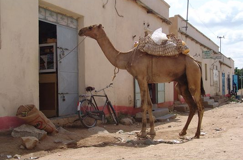
- Barentu, Eritrea
Infobox Settlement
official_name = Barentu
other_name =
native_name = ባረንቱ
nickname =
settlement_type =
motto =
imagesize = 300px
image_caption =
flag_size =
image_
seal_size =
image_shield =
shield_size =
mapsize =
map_caption = Map of Barentu in Eritrea
mapsize1 =
map_caption1 =
image_dot_
dot_mapsize =
dot_map_caption =
dot_x = |dot_y =
pushpin_
pushpin_label_position =
pushpin_map_caption =
pushpin_mapsize =
subdivision_type = Country
subdivision_name =Eritrea
subdivision_type1 =
subdivision_name1 =
subdivision_type2 =
subdivision_name2 =
subdivision_type3 =
subdivision_name3 =
subdivision_type4 =
subdivision_name4 =
government_footnotes =
government_type =
leader_title =
leader_name =
leader_title1 =
leader_name1 =
leader_title2 =
leader_name2 =
leader_title3 =
leader_name3 =
leader_title4 =
leader_name4 =
established_title =
established_date =
established_title2 =
established_date2 =
established_title3 =
established_date3 =
area_magnitude =
unit_pref =Imperial
area_footnotes =
area_total_km2 =
area_land_km2 =
area_water_km2 =
area_total_sq_mi =
area_land_sq_mi =
area_water_sq_mi =
area_water_percent =
area_urban_km2 =
area_urban_sq_mi =
area_metro_km2 =
area_metro_sq_mi =
population_as_of = 2003
population_footnotes =
population_note =
population_total =
population_density_km2 =
population_density_sq_mi =
population_metro =
population_density_metro_km2 =
population_density_metro_sq_mi =
population_urban =
population_density_urban_km2 =
population_density_urban_sq_mi =
population_blank1_title =
population_blank1 =
population_density_blank1_km2 =
population_density_blank1_sq_mi =
timezone = EAT
utc_offset = +3
timezone_DST =
utc_offset_DST =
latd=15 |latm=07 |lats= |latNS=N
longd=37 |longm=36 |longs= |longEW=E
elevation_footnotes =
elevation_m =
elevation_ft =
postal_code_type =
postal_code =
area_code =
blank_name =
blank_info =
blank1_name =
blank1_info =
website =
footnotes =Barentu ( _ti. ባረንቱ) is a town in south-western
Eritrea , lying south ofAgordat . It is mainly inhabited by theNilotic Kunama people . It is located in theGash-Barka Zone of Eritrea.The town has typically been a center of mining and agricultural activities for the area. The town suffered major damage during theEritrean-Ethiopian War but has since under gone reconstruction.Nearby towns and villages include
Tauda (8.0 nm),Alegada (6.9 nm),Dedda (7.2 nm),Augana (3.2 nm),Cona (5.7 nm) andDaghilo (7.8 nm).References
* [http://www.fallingrain.com/world/ER/0/Barentu.html FallingRain
]
Wikimedia Foundation. 2010.

