- Arrondissement of Oudenaarde
-
Arrondissement of Oudenaarde
Arrondissement Oudenaarde
Arrondissement d'Audenarde— Arrondissement — Location of the arrondissement in East-Flanders
Coordinates: 50°51′N 3°36′E / 50.85°N 3.6°ECoordinates: 50°51′N 3°36′E / 50.85°N 3.6°E Country  Belgium
Region  Flemish Region
Province  East Flanders
Municipalities 11 Area – Total 418.80 km2 (161.7 sq mi) Population (01/01/2006) – Total 116,098 – Density 277.2/km2 (718/sq mi) Time zone CET (UTC+1) – Summer (DST) CEST (UTC+2) 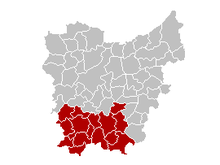 Location of the judicial arrondissement in East-Flanders
The Arrondissement of Oudenaarde (Dutch: Arrondissement Oudenaarde; French: Arrondissement d'Audenarde) is one of the six administrative arrondissements in the Province of East Flanders, Belgium. It is both an administrative and a judicial arrondissement. However, the Judicial Arrondissement of Oudenaarde also comprises the municipalities of Geraardsbergen, Herzele, Sint-Lievens-Houtem and Zottegem in the Arrondissement of Aalst.
Municipalities
The Administrative Arrondissement of Oudenaarde consists of the following municipalities:
Administrative arrondissements of BelgiumBrussels-Capital Region Brussels-CapitalFlemish Region Aalst · Antwerp · Bruges · Dendermonde · Diksmuide · Eeklo · Ghent · Halle-Vilvoorde · Hasselt · Kortrijk · Leuven · Maaseik · Mechelen · Ostend · Oudenaarde · Roeselare · Sint-Niklaas · Tielt · Tongeren · Turnhout · Veurne · Ypres-Ieper
Walloon Region Judicial arrondissements of BelgiumCategories:- Arrondissement in East Flanders
- Arrondissements of Flanders
- East Flanders geography stubs


Wikimedia Foundation. 2010.