- Woodlark Island
-
Woodlark Native name: Muyua, Muyuw 
Woodlark Islands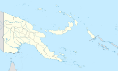
 Woodlark Island (Papua New Guinea)
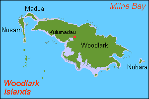
Geography Location Melanesia Coordinates 9°7′35″S 152°48′20″E / 9.12639°S 152.80556°E Country Province Milne Bay Province Woodlark Island, known to its inhabitants simply as Woodlark or Muyua, is an island in Milne Bay Province, Papua New Guinea. It is called Murua by the inhabitants of some other islands in the province. Muyuw language, one of the Kilivila–Louisiades languages and part of the Austronesian language family, is spoken on the island.
The wider Woodlark Islands group also consists of Madau and Nusam to the west, Nubara to the east, and the Marshall Bennett group to the southwest.
Contents
Conservation
A plan by the Malaysian company Vitroplant to use 70% of the island for palm oil production was scrapped after opposition from the islands inhabitants.[1][2][3] The project was seen as a threat to endemic organisms on the island.[3] As of 2009, a full wildlife survey of the island had not yet been carried out.[1]
History
Operation Chronicle was the name given to the landing of Allied forces on Woodlark Island and Kiriwina on June 30, 1943, during World War II. Within a few months of the landing U.S. Navy Seabees had constructed a major airbase at Guasopa Bay, known as Woodlark Airfield (later Guasopa Airport).
References
- ^ a b Gascoigne, Ingrid. Papua New Guinea (Cultures of the World). 2009-03. Benchmark Books. p. 54. ISBN 978-0761434160.
- ^ "70% of rainforest island to be cleared for palm oil". Mongabay.com. 2007-12-13. http://news.mongabay.com/2007/1213-woodlark.html. Retrieved 16 September 2010.
- ^ a b [Biofuels versus Native Rights: "Biofuels versus Native Rights: Planned logging of Woodlark Island for biofuels opposed by islanders and scientists"]. Mongabay.com. 2007-11-12. Biofuels versus Native Rights:. Retrieved 16 September 2010.
External links
Categories:- Islands of Papua New Guinea
- Milne Bay Province
- Papua New Guinea geography stubs

Wikimedia Foundation. 2010.