- Millbrook (Bedfordshire) railway station
-
Millbrook 
Location Place Millbrook Local authority Central Bedfordshire Operations Station code MLB Managed by London Midland Number of platforms 3 Live arrivals/departures and station information
from National Rail EnquiriesAnnual rail passenger usage 2002/03 * 10,928 2004/05 *  11,744
2005/06 * 12,8282006/07 * 13,6712007/08 *  12,303
2008/09 * 13,9942009/10 * 12,758History 17 November 1846 Opened (Marston) March 1847 Renamed (Ampthill) January 1850 Renamed (Ampthill (Marston)) March 1877 Renamed (Millbrook for Ampthill) 1 July 1910 Renamed (Millbrook)[1] 3 August 1964 Goods services withdrawn 15 July 1968 Became unstaffed[2] National Rail - UK railway stations A B C D E F G H I J K L M N O P Q R S T U V W X Y Z * Annual passenger usage based on sales of tickets in stated financial year(s) which end or originate at Millbrook from Office of Rail Regulation statistics. Please note: methodology may vary year on year. - This article is about the Millbrook station in Bedfordshire. For the Millbrook station in Hampshire, see Millbrook (Hampshire) railway station.
Millbrook railway station serves the villages of Millbrook and Marston Moretaine in Bedfordshire, England. It is located on the Marston Vale Line, between Stewartby and Lidlington. Millbrook is also the principal stop for the Marston Vale Millennium Country Park.
Contents
Services
Millbrook, in common with other stations on the Marston Vale Line, is covered by the Marston Vale Community Rail Partnership[1]. The Partnership aims to increase use of the line by getting local people involved with their local line.
Preceding station  National Rail
Following station London Midland Mondays-Saturdays onlyHistory
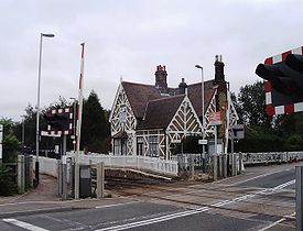
First opened in 1846 by the Bedford Railway, the station was originally named "Marston", but changed to "Ampthill (Marston)" in 1850 after the nearby village. The opening of a second and more conveniently-sited Ampthill station by the Midland Railway in 1868 on its Midland Main Line gave rise to confusion which was only resolved in 1877 when the original Ampthill station was renamed "Millbrook for Ampthill". The station is the fourth and final on the Marston Vale Line to be built in a half-timbered Gothic style which had been insisted upon by the Duke of Bedford for stations situated in the vicinity of the Woburn Estate. The two station platforms are situated to the east of a level crossing.[3]
The station developed substantial coal traffic, as well as trade in cattle and goods with stables in its goods yard and a wagon repairers. A public house called the "Morteyne Arms" opened opposite the station. Traffic increased still further with the development of the brick industry in the area; a siding was opened on 7 May 1928 to cater for the trade in bricks, the towers of the Millbrook Brick Company could be seen from the station.[4] The brick traffic peaked in the 1930s, with a second brickworks called "Marston Moretaine" being opened a mile from the station; although it was too far for a siding, bricks were transported by road to the station where they were loaded on to rail wagons.[5]
The station, whose name was changed to "Millbrook" in 1910, was reduced to an unstaffed halt in 1968, having lost its formerly substantial goods facilities four years previously.[2] The station building was restored in the early 1980s and converted into a private residence. In 1999, the low station platforms - the last of their type remaining on the line - were rebuilt to the standard height appropriate to modern trains.[6]
Preceding station Disused railways Following station Lidlington British Railways
Varsity LineStewartby References
- ^ Butt, R.V.J. (1995). The Directory of Railway Stations, Patrick Stephens Ltd, Sparkford, ISBN 1-85260-508-1, p. 160.
- ^ a b Clinker, C.R. (October 1978). Clinker's Register of Closed Passenger Stations and Goods Depots in England, Scotland and Wales 1830-1977. Bristol: Avon-AngliA Publications & Services. p. 96. ISBN 0-90546-619-5.
- ^ Simpson, Bill (1981). Oxford to Cambridge Railway (Vol. 2). Poole, Dorset: Oxford Publishing Co.. p. 55. ISBN 0-86093-121-8.
- ^ Simpson, B., p. 65.
- ^ Simpson, B., p. 60.
- ^ Simpson, Bill (2000). The Oxford to Cambridge Railway: Forty Years On 1960-2000. Witney, Oxford: Lamplight Publications. pp. 72–73. ISBN 1-89924-605-3.
External links
- Train times and station information for Millbrook (Bedfordshire) railway station from National Rail
- Details from listed building database (38357) . Images of England. English Heritage.
- Station on navigable 1946 O.S. map.
Coordinates: 52°03′14″N 0°32′02″W / 52.0538°N 0.5338°W
Railway stations in Bedfordshire West Coast Main Line Midland Main Line East Coast Main Line Marston Vale Line Aspley Guise • Bedford • Bedford St Johns • Kempston Hardwick • Lidlington • Millbrook • Ridgmont • StewartbyCategories:- Transport in Bedfordshire
- Grade II listed buildings in Bedfordshire
- Railway stations in Bedfordshire
- Former London and North Western Railway stations
- Railway stations opened in 1846
- Railway stations served by London Midland
- DfT Category F2 stations
- Ampthill

Wikimedia Foundation. 2010.