- Paraty
Infobox City
official_name = Paraty
imagesize = 250px
image_caption = Paraty from the Bay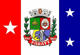
image_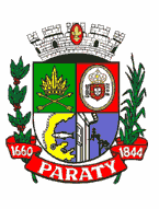

mapsize = 250px
map_caption = Location in Rio de Janeiro state.
subdivision_type = Country
subdivision_type1 = Region
subdivision_type2 = State
subdivision_name =Brazil
subdivision_name1 = Southeast
subdivision_name2 = Rio de Janeiro
demonym = Paratiense
leader_title = Mayor
leader_name = José Carlos Porto Neto
area_note =
area_magnitude = 1 E9
area_total_km2 = 928.47
population_as_of = 2005
population_total = 33,062
timezone =UTC-3
utc_offset = -3
timezone_DST =UTC-2
utc_offset_DST = -2
latitude = 23º13'30" S
longitude = 46°58' W
elevation_m = 5
elevation_ft =
website = [http://www.paraty.tur.br] www.paraty.tur.br
footnotes = Postal Code (CEP): 23970-000Located on the Costa Verde (Green Coast), a lush, green corridor that runs along the coastline of the state of Rio de Janeiro, in Brazil, Paraty (or Parati) [pronounced "Par-a-CHEE"] is a preserved Portuguese colonial and Brazilian Imperial (1822-1889) town. Paraty has become a popular tourist area in recent years, renowned for the beauty of the town and the magnificence of the coast and mountains in the region.The town is located on the Bay of Ilha Grande, which is dotted with many tropical islands. Rising up some 1,000 meters behind the town are the
tropical forest s, mountains, and waterfalls.Paraty is surrounded by many Nature Parks including
Serra da Bocaina National Park,Serra do Mar State Park, the Park Reserve of Joatinga and the Environmentally Protected Area of Cairuçu, where the village of Trindade is located.The temperature in Paraty ranges from 64F - 80F, (18C to 30C), though the summer months could be even hotter. However, sea breezes temper the heat and afternoon rains are common in the Summer making the city a popular destination for visitors from São Paulo, Rio de Janeiro, the rest of Brazil, and the world.
Flag of Paraty
The flag of Paraty was adopted on
August 12 ,1967 . The overall colors of the flag represent the following traits: gold signifies strength, silver represents innocence, red is bravery, blue serenity, and green is the color of abundance.Red, white, and blue are the three colors that have traditionally been used to decorate the historic houses of the city. The colors are displayed in three vertical stripes, with a coat of arms on the center. The large white star on the red stripe symbolizes the first district, and on the blue stripe two small stars represent the second and third districts. The three stars are placed in a triangular form, in homage to the strong presence of
Freemasonry in the architecture of the city.The coat of arms shown on the flag was adopted on
November 30 ,1960 . The four quarters of the coat of arms symbolize the following:# The first green-colored quarter on the upper left-hand side with a feathered headdress above two crossed arrows, represents the original inhabitants of the region, the Guaianás tribe.
# The second quarter in red with a white oval seal with the royal Portuguese coat of arms surrounded by the word "Remédios," a seal which was used in colonial times to authenticate official documents; Our Lady of Remedies has been patron saint of the town since 1646.
# The third quarter, which is white, blue and yellow is an outline of the city and the bay with a superimposed silver fish that is perhaps a reference to Tupi language origin of the city name.
# Finally the fourth quarter of blue shows the corner of a colonial house and awrought-iron rail which is representative of the colonial-style houses that exemplify Paraty.The flora which supports the red scroll are a branch of
coffee tree and a stalk ofsugarcane . The scroll itself bears the inscription “1660 Paraty 1844” These are the dates that Paraty initially achieved status as a town and then later city status. Above the shield is a crown consisting of five towers, with the center tower emblazoned with a red shield bearing a gold fleur-de-lis, which symbolizes Our Lady of Remedies, the patron saint of the city.History
Paraty was founded formally as a town by Portuguese colonizers in 1667, in a region populated by the Guaianás Indians.
The Guaianás people who lived where the city now stands called the entire area “Paraty”. In the Tupi language “Paraty” means “river of fish”. Even today the Brazilian Mullet ("Mugil Brasiliensis") still come back to spawn in the rivers that spill into the Bay of Paraty. When the region was colonized by the Portuguese, they adopted the Guaianás name for their new town.
The Gold Trail
After the discovery of the world's richest gold mines in 1696 in the mountains of
Minas Gerais , Paraty became an export port for gold to Rio de Janeiro and from there on toPortugal . The ensuing gold rush led to the construction of the "Caminho do Ouro" or "Gold Trail", a 1200 kilometer road, paved in steep areas with large stones, which connected Paraty toDiamantina viaOuro Preto and Tiradentes. Not only was it was used to transport gold to Paraty, but it was also used to convey supplies, miners and African slaves by mule train over the mountains to and from the gold mining areas. Two substantial sections of the Caminho do Ouro have been excavated near Paraty and are now a popular tourist destination for hiking.The Gold Trail fell into disuse because of attacks on the gold laden ships bound for Rio de Janeiro by pirates who frequented the islands and coves of the Bay of Angra dos Reis. Eventually a safer overland route from Minas Gerais to Rio de Janeiro was created because of these pirate raids. Finally, the gold itself began to run out in the late 1700s, and Paraty declined.
The Gold Trail was submitted for inclusion on the
World Heritage List in August 2004.Economic Revival
The city's economic activity revived as a port for a new boom, the coffee trade of the
Paraiba do Sul River Valley in the early 1800s, until a railway along the valley created cheaper transport to the port of Rio de Janeiro. Another smaller revival came late in the 19th century with the production ofcachaça , which is a sugarcane-derived spirit best known today as the basis for Brazil's most famous drink, thecaipirinha . The name "Paraty" in that period became synonymous with cachaça. Since then, Paraty has been out of the mainstream, which is why it did not change for centuries, until a paved road was built from Rio de Janeiro to Santos, near São Paulo, in the 1970s. The city then began a new cycle of activity, which transformed a small, almost abandoned town living on very limited economic activity, mainlyfishing andagriculture (banana s,manioc , sugarcane] into what is now known as one of the "must see" tourism attractions in Brazil.The city was declared a
UNESCO World Heritage site in 1966.Architecture
Paraty is known for the
cobblestone -paved streets throughout the Historic Center District. No cars or trucks are allowed in this part of town. Only foot traffic or bicycles. Motor vehicles are only allowed in the Historic District on Wednesdays for deliveries. Horses and carts are a very common sight in Paraty and are frequently used all around the city.Paraty has been able to maintain many of its historic buildings. Much of the
architecture of the city has not changed for 250 years or more.Churches
There are four important historic
baroque churches in Paraty:Capela de Santa Rita (Chapel of Saint Rita)
Capela de Santa Rita is the oldest church in Paraty. It was completed in 1722. This was the church of the white elite and freeman, former slaves who earned or paid for their freedom. It is currently home to the Museum of Sacred Art.
Igreja de Nossa Senhora do Rosário e São Benedito (Church of Our Lady of the Rosary and Saint Benedict)
This church was built and used by Paraty’s African slaves. It dates back to the year 1725. The church has a much simpler, more rustic style than the other three churches in Paraty. Every year in the first week of December the festivities of São Benedito are held in this church.
Capela de Nossa Senhora das Dores (Chapel of Our Lady of Sorrows)
This chapel dates back to 1800. It was used mostly by the rich women of society. Construction was overseen by the presiding priest, Father Antonio Xavier da Silva Braga. The building was later renovated in 1901. The image of Nossa Senhora da Piedade was stolen from this chapel. It was finally recovered in the 1990s, and now can be seen at the Museum of Sacred Art in the Capela de Santa Rita.
Igreja Matriz Nossa Senhora do Remédios (First Church of Our Lady of the Remedies)
Igreja Matriz Nossa Senhora do Remédios is the largest church in Paraty. It takes up over an entire city block. Its construction began in 1646 when a woman named Maria Jácome de Melo donated the land for the construction of the village of Paraty, however she demanded two conditions: The first was the building of a chapel dedicated to Nossa Senhora dos Remédios and the second was that no one would harm the Indians that lived in the area at that time. The church was completed in 1873. The back part of the structure was never finished because they ran out of money. Another reason that it was never completed is that possibly because of its proximity to the bay and the river, the whole block started to sink under the heavy weight of the church. Within the sanctuary the images of Nossa Senhora dos Remédios, São José Arcanjo, and Senhor dos Passos can be seen.
Capela da Generosa (Chapel of the Generous Woman)
Additionally there is a very small chapel called Capela da Generosa which according to legend, was constructed in 1901 by the order of a generous female patron, in memory of Teodoro. Teodoro supposedly drowned in the river Perequê-Açu when he tried to fish on Holy Friday, a day on which according to tradition it was not recommend to fish.
There are also historical churches in two nearby small villages, Paraty Mirim and Penha:
Capela Nossa Senhora da Conceição (Chapel of Our Lady of the Conception)
Paraty-Mirim (Little Paraty) is the site of first chapel built by settlers in the region around Paraty (1686). At the time of its construction Paraty-Mirim an important commercial center and thriving village. Today however, all that remains there are the church itself and a scattering private homes. Although in recent years the tourist trade has grown there due to the pristine beaches in the area and Paraty-Mirim now has a few small inns, a couple of restaurant/bars and offers boat tours.
Igreja de Nossa Senhora da Penha (Church of Our Lady of the Rock)
This church is unique in that it was built on top of a huge boulder in the small hamlet of Penha, just outside Paraty. The church is located directly across from the Tourist Information Center at the trail-head of the Caminho do Ouro.
Forts
There are two colonial
forts in Paraty:Forte Defensor
Forte Defensor was built in 1703 and outfitted with six cannons for the protection of the city’s important commercial warehouses. With the aforementioned economic decline of the region, it was in ruins until 1822, when it was reconstructed and dedicated to Emperor Dom Pedro I. Some historians believe that it was at the fort that the first nucleus of the town began, in that the area around the fort is still referred to as the “Old Village.”
Ruins of the old, rock defensive walls together with the cannons can still be seen today. It is also home to a Powder House for storing explosives - one of the few still existing in Brazil. Forte Defensor is one of seven fortifications that were built around the harbor of Paraty, two of them being in the city. All of the others that were constructed outside the city are now only ruins.
Forte Patitiba [Cadeia Antiga]
What is left of this Fort, also known as Cadeia Antiga (the Old Jail) is a smallish structure which for a while was also used as a prison. It is found in the plaza of Santa Rita, next to the church of same name. Constructed in the beginning of 18th century, the building was part of a larger Forte Patitiba, the other blockhouse built in the city for defense of the harbor. In Nineteenth century it was decommissioned and today it houses the local Public Library.
There are also many colorful, colonial houses (refurbished in most cases), many of which have been transformed into shops, pousadas (Brazilian bed and breakfasts),
restaurant s and bars.Flooded Streets
Thanks to Portuguese engineering involving an ingenious curvature of the cobblestone streets, Paraty is home to a unique phenomenon. Once a month when there is a Full Moon and the tide is high, seawater rises from its normal levels, and pours into the Historic Center District through special openings in the
seawall s that separate the city from the harbor. The streets are only flooded for a short time, until the tide recedes. The water is usually only six to ten inches deep and a few merchants near the seawall put out small bridges to span the flooded streets for the benefit of pedestrians.Neighborhoods
Paraty is divided into 12 neighborhoods. They are as follows:
Caboré
Centro Historico
Fátima
Ilha das Cobras
Jabaquara
Mangueira
Parque Imperial
Parque Ypê
Patitiba
Portal de Paraty
Saudade
Vila Colonial
Culture and Tourism
There are many musical and cultural events, the most prominent of which is the
International Literary Festival of Paraty . The town is also known for its local festivals on Catholic holy dates, such as the Feast of the Holy Ghost.Casa da Cultura
The Casa da Cultura Paraty (House of Culture) occupies an historic 18th century house which opened to the public in 2004 and holds a permanent exhibition on local history and culture. In the Salon of Indigenous Culture, visitors can see the “carpets” made of colored sawdust and flower petals used during the festival of Corpus Christi in June. The largest is almost 92 square feet. The “carpet” is protected by glass so that visitors walk on it as they enter.
The House of the Culture houses a permanent exposition idealized by the director and theatrical designer Bia Lessa. The collection presents all manner of items from the daily lives of the Paratienses (the name given to residents of Paraty). The items are hung from the ceiling in acrylic boxes and can be pulled down for examination by ribbons hanging from each box. The city’s inhabitants have donated many of the objects in the exposition. There are also more than 140 photographs and numerous video screens that show a slice of life of citizens from every social standing from all over the city. It took nearly two years to prepare the exhibits for viewing.
It also has an auditorium, a bookstore, a small café, and a shop that sells local art and handcrafts. Two computer terminals also offer tips for the tourists who visit the city. One of the functions of the House of the Culture is to assemble a complete overview of the area so that the visitors can explore the vast cultural offerings of the region.
Some of the annual events in Paraty are as follows:
January
Paraty Cultural Festival
February
Carnamar -Carnival on the Sea! Bloco da Lama- A mudfest!
Carnival
The anniversary of the founding of Paraty
April Easter Week Seafood Festival
May
Divino Festival: A festival that began in the
Middle Ages in Portugal. It includes typical folk-dances, puppets, music, processions and fireworks. It is one of the most popular and beautiful festivals.June
Corpus Christi: The city is decorated with flowers and works of sacred art. The streets are decorated with "rugs" which depict secular and religious scenes. These “rugs” are made from flower petals, leaves and colored sawdust.
July
International Literature Festival of Paraty (FLIP) Festival of Santa Rita
August
Paraty Art Festival
Pinga Festival of Paraty: The local producers of pinga (sugar cane liquor), also known as cachaca, organize this event where you can taste numerous varieties of pinga. Top Brazilian musicians also perform.
September
Nossa Senhora de Remédios Festival
Brazilian Independence Day
Spring Festival
November
Festival of St. Benedito and Rosário
Afro-Brazilian Cultural Festival Folia Gastronômica: A Food Festival
December
Christmas
New Years: Live music and a fireworks display.
Getting to Paraty
Paraty can be reached by air from Rio de Janeiro or São Paulo, but only by chartered helicopter or small commercial and private aircraft because it only has a very small airstrip.
Another possibility of transport is to arrive by sea by way of a sailboat or cruise ship from Rio de Janeiro, Angra dos Reis and Ilha Grande.
The third and most common means of travel to Paraty is to make the trip by car or bus from Rio de Janeiro or São Paulo (via road BR-101). Air-conditioned buses leave to go back and forth from Rio to Paraty and Paraty to Rio every one and a half hours from around 4:00 am until about 10:00pm. Buses to and from São Paulo run every 4 hours. There is a non-air-conditioned local bus that goes from Paraty to Angra dos Reis and from there one can catch another bus to Rio de Janeiro. There is also the option of catching a "Van" in Angra dos Reis, one of the many privately owned mini-buses that provide an alternative form of transport throughout Brazil.
Distance from other Brazilian cities
*
Angra dos Reis - 95 km
*Belo Horizonte - 572 km
*Caraguatatuba - 126 km
*Rio de Janeiro - 236 km
*Sao Paulo - 330 km
*Ubatuba - 74 kmReferences
* [http://www.paraty.tur.br Tourism in Paraty flagicon|Brazil pt icon]
External links
* [http://www.paraty.tur.br Paraty Tourist Guide flagicon|Brazil pt icon]
* [http://www.blocodalama.com.br/blocodalama/ Bloco da Lama (the Mudfest!) flagicon|Brazil pt icon]
* [http://www.paraty.tur.br/history/goldpathway.php Caminho do Ouro- Official government operated facility flagicon|Brazil pt icon]
* [http://www.caminhodoouro.com.br/ Caminho do Ouro- Privately owned facility flagicon|Brazil pt icon]
* [http://www.flip.org.br/ FLIP (Festa Literária Internacional de Parati)]
* [http://www.paratyhostels.com/ Hostels in Paraty]
* [http://www.foliagastronomica.com.br/ Annual Gastronomic Festival flagicon|Brazil pt icon]
*wikitravel
* [http://www.paratigreenmap.org Green Map System Parati]
* [http://www.riodejaneirophotoguide.com/html/parati.html Paraty Photo Galleries]

Wikimedia Foundation. 2010.