- Wellfleet, Massachusetts
Infobox Settlement
official_name = Wellfleet, Massachusetts
nickname =
motto =
imagesize =
image_caption = Wellfleet Town Hall
image_
mapsize = 250px
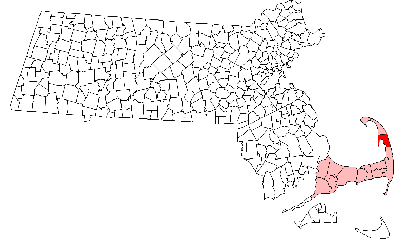
map_caption = Location in Barnstable County in Massachusetts
mapsize1 =
map_caption1 =
subdivision_type = Country
subdivision_name =United States
subdivision_type1 = State
subdivision_name1 =Massachusetts
subdivision_type2 = County
subdivision_name2 = Barnstable
established_title = Settled
established_date = 1724
established_title2 = Incorporated
established_date2 = 1775
established_title3 =
established_date3 =
government_type =Open town meeting
leader_title =
leader_name =
leader_title1 = Board of
Selectmen
leader_name1 =Board of Selectmen
area_magnitude =
area_total_km2 = 91.6
area_total_sq_mi = 35.4
area_land_km2 = 51.4
area_land_sq_mi = 19.8
area_water_km2 = 40.2
area_water_sq_mi = 15.5
population_as_of = 2000
settlement_type = Town
population_total = 2749
population_density_km2 = 53.5
population_density_sq_mi = 138.6
elevation_m = 15
elevation_ft = 50
timezone = Eastern
utc_offset = -5
timezone_DST = Eastern
utc_offset_DST = -4
latd = 41 |latm = 56 |lats = 15 |latNS = N
longd = 70 |longm = 02 |longs = 00 |longEW = W
website = http://www.wellfleetma.org/
postal_code_type = ZIP code
postal_code = 02667, 02663
area_code = 508 / 774
blank_name = FIPS code
blank_info = 25-74385
blank1_name = GNIS feature ID
blank1_info = 0618261
footnotes =Wellfleet is a town in Barnstable County,
Massachusetts ,United States . Located halfway between the "tip" and "elbow" ofCape Cod , Massachusetts, the town had a population of 2,749 at the 2000 census, which swells nearly sixfold during the summer.Fact|date=March 2008 Nearly half of the land area of Wellfleet is part of theCape Cod National Seashore and a total of 70% of the town's land area is in some form of protection. Wellfleet is famous for its eponymousoyster s, which are celebrated in the annual October Wellfleet OysterFest. The town has the second greatest concentration of art galleries on Cape Cod, right after Provincetown.History
Wellfleet was encountered by Europeans as early as 1606, when the French explorer
Samuel de Champlain explored and named it "Port Aux Huitres" (Oyster Port) for the bountiful oyster population resident to the area. Originally settled in the 1650s by the Europeans as Billingsgate (after the famous fish market in East London), Wellfleet was part of neighboring Eastham until 1763, achieving town status after nearly 30 years of petitioning. The name "Wellfleet" is disputed; some argue that it comes from "Whale Fleet," after the burgeoning whaling industry in the town, while some say it comes from a brand of oyster popular in England at the time, in order to help sales.Wellfleet's oyster beds drove the early economy, as did whaling and other fishing endeavors. The town was home to 30 whaling ships by the American Revolution. However, because of the decline of whaling and the
mackerel catch in the late nineteenth century, the fleet declined, being completely free ofschooner s by 1900. The oyster fleet continues to this day, however, harvesting many other types of shellfish as well.Guglielmo Marconi built America's first transatlantic radio transmitter station in Wellfleet in 1901. The first radio telegraph transmission from America to England was sent from his Wellfleet station on January 18, 1903, a ceremonial telegram from PresidentTheodore Roosevelt to King Edward VII. Most of the Wellfleet transmitter site is gone, however, as three quarters of the land it originally encompassed has been eroded into the sea.In 1961, President
John F. Kennedy created theCape Cod National Seashore , which encompasses most of the Atlantic shoreline of Cape Cod. In Wellfleet the territory circles the town, from Jeremy Point through the swamps and "islands" along the Herring River, and extending the length of the Atlantic shore of the town.Construction of the Chequesset Inn in the late 1800s lead to the development of Wellfleet's large tourist economy. Today, Wellfleet also has many galleries and retirement communities. [
[http://www.wellfleetma.org/Public_Documents/WellfleetMA_WebDocs/about.shtml#history History of Wellfleet, from WellfleetMA.org] ] ["Cape Cod, Martha's Vineyard and Nantucket Street Atlas." South Easton, MA: Arrow Maps Inc., 2004, p. 87.]
Geography
According to the
United States Census Bureau , the town has a total area of 35.4square mile s (91.6km² ), of which, 19.8 square miles (51.4 km²) of it is land and 15.5 square miles (40.2 km²) of it (43.89%) is water. Wellfleet is bordered by Truro to the north, theAtlantic Ocean to the east, Eastham to the south, andCape Cod Bay to the west. Wellfleet is approximately fourteen miles south of Provincetown, thirty-three miles (by road) northeast of Barnstable, forty-eight miles from theSagamore Bridge , and one hundred miles (by road) southeast of Boston.The lands of Wellfleet wrap around Wellfleet Harbor, extending from the main portion of the Cape around the harbor to Jeremy Point. At one time, Wellfleet Harbor included an island known as
Billingsgate Island , which sat at the harbors mouth, to the south of the point. Once a flourishing small community with alight house , the island was destroyed by coastalerosion and now exists as a shoal that is exposed at low tide. The Billingsgate shoals are split between Wellfleet and neighboring Eastham. Several other inlets extend inland from the harbor, at the mouth of the Herring River (also called "The Gut"), Duck Creek, Blackfish Creek and "The Run," which leads to several brooks.In addition to the Seashore, Wellfleet Bay Wildlife Sanctuary, run by Massachusetts Audubon, surrounds much of The Run, including part of Small Island (between The Run and Blackfish Creek). Between the sanctuary, seashore and other small parks and beaches, seventy percent of the town's area is protected.
Transportation
U.S. Route 6 passes from north to south through the town. The town's commercial center lies west of the route, along the shores of the harbor. The route was straightened in the mid-twentieth century, and some maps still consider the "old" Route 6 to be a portion of Route 6A. The town has no rail or air service. The nearest municipal airports are in Chatham and Provincetown, both about eighteen miles from town; the nearest national and international service can be found atLogan International Airport in Boston.There is currently limited bus transportation into Wellfleet from Logan airport and the Upper Cape on Plymouth & Brockton Street Railway Company, the Cape's local commuter service.
Demographics
As of the
census GR|2 of 2000, there were 2,749 people, 1,301 households, and 724 families residing in the town. Thepopulation density was 138.6 people per square mile (53.5/km²). There were 3,998 housing units at an average density of 201.6/sq mi (77.8/km²). The racial makeup of the town was 96.58% White, 0.95% African American, 0.29% Native American, 0.36% Asian, 0.04% Pacific Islander, 0.58% from other races, and 1.20% from two or more races. Hispanic or Latino of any race were 0.69% of the population.There were 1,301 households out of which 20.0% had children under the age of 18 living with them, 44.8% were married couples living together, 8.2% had a female householder with no husband present, and 44.3% were non-families. 34.8% of all households were made up of individuals and 13.2% had someone living alone who was 65 years of age or older. The average household size was 2.11 and the average family size was 2.75.
In the town the population was spread out with 17.8% under the age of 18, 4.9% from 18 to 24, 23.3% from 25 to 44, 32.2% from 45 to 64, and 21.7% who were 65 years of age or older. The median age was 47 years. For every 100 females there were 89.2 males. For every 100 females age 18 and over, there were 83.5 males.
The median income for a household in the town was $43,558, and the median income for a family was $50,990. Males had a median income of $38,100 versus $35,964 for females. The
per capita income for the town was $25,712. About 5.7% of families and 7.5% of the population were below thepoverty line , including 9.7% of those under age 18 and 6.0% of those age 65 or over.Government
Wellfleet is represented in the
Massachusetts House of Representatives as a part of the Fourth Barnstable district, which includes (with the exception of Brewster) all the towns east and north of Harwich on the Cape. The town is represented in theMassachusetts Senate as a part of the Cape and Islands District, which includes all of Cape Cod, Martha's Vineyard and Nantucket except the towns of Bourne, Falmouth, Sandwich and a portion of Barnstable. [ [http://www.mass.gov/legis/citytown.htm Index of Legislative Representation by City and Town, from Mass.gov] ] Wellfleet is patrolled by the Second (Yarmouth) Barracks of Troop D of theMassachusetts State Police . [ [http://www.mass.gov/?pageID=eopsterminal&L=5&L0=Home&L1=Law+Enforcement+%26+Criminal+Justice&L2=Law+Enforcement&L3=State+Police+Troops&L4=Troop+D&sid=Eeops&b=terminalcontent&f=msp_divisions_field_services_troops_troop_d_msp_field_troop_d_station_d2&csid=Eeops Station D-2, SP Yarmouth] ]On the national level, Wellfleet is a part of
Massachusetts's 10th congressional district , and is currently represented byBill Delahunt . The state's senior (Class I) member of theUnited States Senate , re-elected in 2006, isTed Kennedy . The junior (Class II) Senator, up for re-election in 2008, isJohn Kerry .Wellfleet is governed by the
open town meeting form of government and aboard of selectmen , who employ a town administrator to oversee day-to-day business. The town has its own police and fire departments, headquartered on Route 6 near the town center. There are two post offices, and both are also located along Route 6. The Wellfleet Public Library is located in the town center, in a former curtain and candle factory converted in 1989.Education
Wellfleet, along with Brewster, Eastham and Orleans, make up the Nauset Regional School District. Each town operates its own elementary schools, with a regional middle school and high school accepting the students of all four towns. Wellfleet Elementary School is located just off of Route 6 near the town center, and serves students from kindergarten to fifth grade. The Nauset Regional Middle School is located in Orleans, and the Nauset Regional High School is located in neighboring Eastham. There are no private schools in Wellfleet; high school students may, however, choose to attend Cape Cod Regional Technical High School in Harwich free of charge.
References
External links
* [http://www.wellfleetma.org Wellfleet town website]
* [http://www.wellfleetoysterfest.org/ Wellfleet OysterFest website]
* [http://www.massaudubon.org/Nature_Connection/Sanctuaries/Wellfleet/index.php Wellfleet Bay Wildlife Sanctuary]
*wikitravel|Wellfleet
Wikimedia Foundation. 2010.