- Tordrillo Mountains
Geobox | Range
name=Tordrillo Mountains
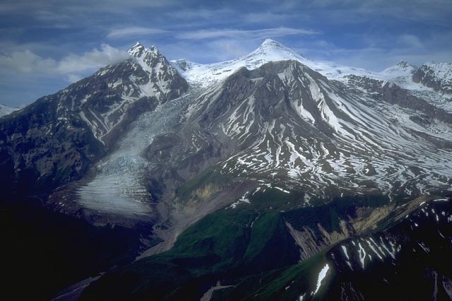
image_caption=Mount Spurr from the south
etymology=
country=United States
state=Alaska
parent=
border=Chigmit Mountains| border1=Alaska Range
geology= | period= | orogeny=
length_imperial=| length_orientation=
width_imperial= | width_orientation=
highest=Mount Torbert
highest_elevation_imperial=11413
highest_lat_d=61|highest_lat_m=24|highest_lat_s=32|highest_lat_NS=N
highest_long_d=152|highest_long_m=24|highest_long_s=50|highest_long_EW=W
map_caption=The Tordrillo Mountains are a small mountain range in the Matanuska-Susitna and Kenai Peninsula Boroughs in the southcentral region of theU.S. state ofAlaska . They lie approximately 75 miles (120 km) west-northwest of Anchorage. The range extends approximately 60 miles (97 km) north-south and 35 miles (56 km) east-west.The highest point isMount Torbert (11,413 feet/3,479 m). On a clear day, they are easily visible from Anchorage.The Tordrillos are bordered on the south by the
Chigmit Mountains , the northernmost extension of theAleutian Range . (The Tordrillos are sometimes counted as part of the Aleutian Range, but this is not official usage.) On the west and north they meet the southern tip of theAlaska Range , while on the east they fade into the hills and lowlands of southcentral Alaska. The north side of the range feeds theSkwentna River , and the south drains intoChakachamna Lake and theChakachatna River .The Tordrillos are primarily a volcanic range, like most of the neighboring Aleutian Range; however some of the peaks (for example, Mount Torbert) are not volcanoes.
Mount Spurr , the southernmost peak in the range, had its most recent eruption in June 1992. They are heavily glaciated, partly due to their location nearCook Inlet . Major glaciers include theCapps Glacier ,Triumvirate Glacier , Hayes Glacier, andTrimble Glacier .Despite their proximity to Anchorage, the Tordrillos see little recreational or climbing activity. However Mount Spurr and nearby
Crater Peak are regularly visited and monitored by theAlaska Volcano Observatory .Named peaks of the Tordrillo Mountains
*
Mount Torbert (11,413 feet/3,479 m)
*Mount Gerdine (11,258 feet/3,431 m)
*Mount Spurr (11,070 feet/3,374 m)
*Hayes Volcano (9,147 feet/2,788 m) [Hayes Volcano is a completely ice-covered volcano, only discovered in 1975, located just to the northeast ofMount Gerdine . It should not be confused with the much more prominent, non-volcanicMount Hayes in theAlaska Range .]
*Crater Peak (7,575 feet/2,309 m) (A subsidiary peak of Mount Spurr)Notes
External links
* [http://www.avo.alaska.edu/volcanoes/cook_inlet.php Alaska Volcano Observatory]
* [http://www.topozone.com/map.asp?lat=61.548&lon=-152.3377&s=1000&size=l&symshow=n&datum=nad83&layer=DRG250 Tordrillo Mountains on Topozone]
*
Wikimedia Foundation. 2010.