- Sucha County
Infobox Settlement
name = Sucha County
native_name = Powiat suski
settlement_type =
image_shield = POL powiat suski COA.svg

map_caption = Location within the voivodeship
map_caption1 = Division into gminas
subdivision_type = Country
subdivision_name = POL
subdivision_type1 = Voivodeship
subdivision_name1 = Lesser Poland
area_total_km2 = 685.75
population_total = 82045
population_as_of = 2006
population_density_km2 = auto
population_urban = 20576
population_blank1_title = Rural
population_blank1 = 61469
coor_type = Sucha Beskidzka
latd = 49
latm = 44
lats = 25
latNS = N
longd = 19
longm = 35
longs = 19
longEW = E
seat =Sucha Beskidzka
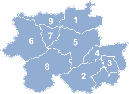
parts_type =Gmina s
parts = Total 9 (incl. 2 urban)
p1 =Jordanów
p2 =Sucha Beskidzka
p3 =Gmina Budzów
p4 =Gmina Bystra-Sidzina
p5 =Gmina Jordanów
p6 =Gmina Maków Podhalański
p7 =Gmina Stryszawa
p8 =Gmina Zawoja
p9 =Gmina Zembrzyce
blank_name = Car plates
blank_info = KSU
website = http://www.powiatsuski.pl/engl.htm __NOTOC__Sucha County ( _pl. powiat suski) is a unit of territorial administration and local government (powiat ) inLesser Poland Voivodeship , southernPoland , on the Slovak border. Its administrative seat and largest town isSucha Beskidzka , which lies convert|44|km|mi|0 south-west of the regional capitalKraków . The county also contains the towns ofMaków Podhalański , lying convert|7|km|mi|0|abbr=on east of Sucha Beskidzka, andJordanów , convert|20|km|mi|0|abbr=on south-east of Sucha Beskidzka.The county covers an area of convert|685.75|km2|sqmi|1. As of 2006 its total population is 82,045, out of which the population of Sucha Beskidzka is 9,726, that of Maków Podhalański is 5,738, that of Jordanów is 5,112, and the rural population is 61,469.
History
Sucha County existed between 1956 and 1975, but on the abolition of the
powiat s its territory was split between the two newly-createdvoivodeship s of Bielsko-Biała and Nowy Sącz. The county was recreated onJanuary 1 ,1999 as a result of the Local Government Reorganization Act of 1998, which restored the powiats and created 16 large voivodeships.Geography
The county is located in the area of the
Beskidy Mountains . Its highest point isBabia Gora , convert|1725|m|ft|abbr=on above sea level, which since1954 has been anational park andBiosphere Reserve .This area attracts significant numbers of tourists, paritcularly to the
skiing centre atZawoja .Sucha County is bordered by
Żywiec County to the west,Wadowice County to the north,Myślenice County to the east andNowy Targ County to the south-east. It also bordersSlovakia to the south-west.Administrative division
The county is subdivided into nine
gmina s (two urban, one urban-rural and six rural). These are listed in the following table, in descending order of population.References
* [http://www.stat.gov.pl/gus/45_655_PLK_HTML.htm Polish official population figures 2006]


Wikimedia Foundation. 2010.