- Oterleek
-
Oterleek — Village — 
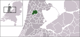
Coat of arms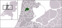 The village centre (dark green) and the statistical district (light green) of Oterleek in the municipality of Schermer.
Coordinates: 52°38′N 4°50′E / 52.633°N 4.833°ECoordinates: 52°38′N 4°50′E / 52.633°N 4.833°E Country Netherlands Province North Holland Municipality Schermer Population (2001) – Total 192 Time zone CET (UTC+1) – Summer (DST) CEST (UTC+2) Postal code Oterleek is a village in the Dutch province of North Holland. It is a part of the municipality of Schermer, and lies about 4 km south of Heerhugowaard.
Oterleek was a separate municipality between 1817 and 1970, when it was merged with Schermer.[1]
In 2001, the village of Oterleek had 192 inhabitants. The built-up area of the village was 0.043 km², and contained 73 residences.[2] The statistical area "Oterleek", which also can include the peripheral parts of the village, as well as the surrounding countryside, has a population of around 420.[3]
References
- ^ Ad van der Meer and Onno Boonstra, Repertorium van Nederlandse gemeenten, KNAW, 2006.
- ^ Statistics Netherlands (CBS), Bevolkingskernen in Nederland 2001. (Statistics are for the continuous built-up area).
- ^ Statistics Netherlands (CBS), Statline: Kerncijfers wijken en buurten 2003-2005. As of 1 January 2005.
External links
- J. Kuyper, Gemeente Atlas van Nederland, 1865-1870, "Oterleek". Map of the former municipality, around 1868.
- People of Oterleek on Familypedia.
Categories:- Populated places in North Holland
- Former municipalities of North Holland
- North Holland geography stubs


Wikimedia Foundation. 2010.