- New York State Route 375
-
NYS Route 375
West Hurley Road 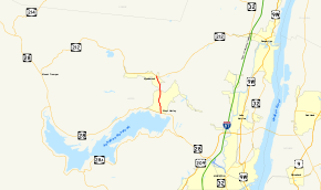
Map of the Ashokan Reservoir and vicinity with NY 375 highlighted in redRoute information Maintained by NYSDOT Length: 2.92 mi[2] (4.70 km) Existed: 1930[1] – present Major junctions South end:  NY 28 in Hurley
North end:  NY 212 in Woodstock
Location Counties: Ulster Highway system Numbered highways in New York
Interstate • U.S. • N.Y. (former) • Reference • County←  NY 374
NY 376  →
→New York State Route 375 (NY 375), locally known as West Hurley Road for its entire length, is a short highway in the Catskill Park located entirely within Ulster County, New York, United States. It primarily allows for more direct access from nearby Kingston to Woodstock. It runs north–south from NY 28 at West Hurley to near the business district of Woodstock, where it terminates at another state highway, NY 212. The route was designated in the 1930 renumbering in New York, replacing a piece of legislative Route 5 from 1908 and has remained unchanged since.
Contents
Route description
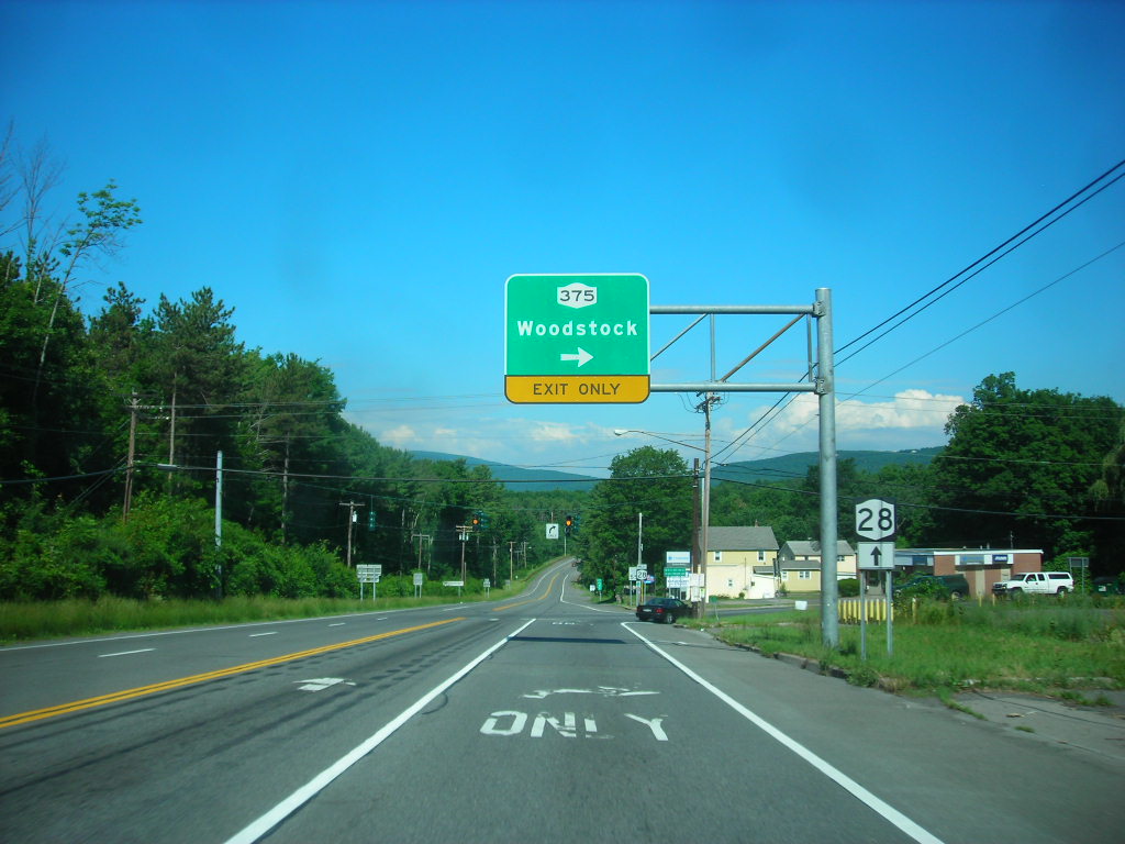
 NY 28 at NY 375
NY 375 begins at an intersection with NY 28 (the Onteora Trail) in the community of West Hurley. The route progresses northward through a densely populated area, passing residential homes and commercial buildings. The highway at the intersection with Pine Street, passing a local sports field, and leaving West Hurley for the rural parts of the Catskill Park. The route continues to wind, and after a distance, intersects the eastern terminus of Maverick Road (County Route 43). The route continues northward, passing the Woodstock Golf Club before entering the hamlet of Zena, where Route 375 ends at an intersection with NY 212 (Mill Hall Road) just outside of Woodstock.[3]
History
The north–south highway linking West Hurley to Woodstock was originally designated as part of Route 5, an unsigned legislative route, by the New York State Legislature in 1908. Route 5 continued east of West Hurley on modern NY 28 and west of Woodstock on what is now NY 212.[4][5] The section of Route 5 between West Hurley and Woodstock was designated as the signed NY 375 as part of the 1930 renumbering of state highways in New York.[1]
Major intersections
The entire route is in Ulster County.
Location Mile[2] Destinations Notes Town of Hurley 0.00 NY 28 (Onteora Trail)Hamlet of West Hurley Woodstock 2.92 NY 212 (Mill Hall Road)Hamlet of Woodstock 1.000 mi = 1.609 km; 1.000 km = 0.621 mi References
- ^ a b Standard Oil Company of New York (1930). Road Map of New York (Map). Cartography by General Drafting.
- ^ a b "2008 Traffic Data Report for New York State" (PDF). New York State Department of Transportation. June 16, 2009. p. 302. https://www.nysdot.gov/divisions/engineering/technical-services/hds-respository/NYSDOT_Traffic_Data_Report_2008.pdf. Retrieved December 9, 2009.
- ^ Yahoo! Inc. Yahoo! Maps – overview map of NY 375 (Map). Cartography by NAVTEQ. http://maps.yahoo.com/#mvt=h&lat=42.036891&lon=-74.104609&zoom=17&q1=41.99726%2C-74.104781&q2=42.037114%2C-74.110725. Retrieved June 20, 2009.
- ^ State of New York Department of Highways (1909). The Highway Law. Albany, New York: J. B. Lyon Company. p. 55. http://books.google.com/books?id=jZ0AAAAAMAAJ&pg=PA55. Retrieved June 20, 2009.
- ^ New York State Department of Highways (1920). Report of the State Commissioner of Highways. Albany, New York: J. B. Lyon Company. p. 507. http://books.google.com/books?id=Sj4CAAAAYAAJ&pg=PA507. Retrieved June 20, 2009.
External links
Categories:- State highways in New York
- Transportation in Ulster County, New York


Wikimedia Foundation. 2010.