California State Route 172
- California State Route 172
Infobox road
state=CA
type=SR
route=172
section=472
maint=Caltrans
length_mi=8.95
length_round=2
length_ref=[ [http://www.dot.ca.gov/hq/structur/strmaint/brlog2.htm January 1, 2006 California Log of Bridges on State Highways] ] ]
direction_a=West
terminus_a=jct|state=CA|SR|36 at Mineral
direction_b=East
terminus_b=jct|state=CA|SR|36 at Morgan Springs
previous_type=SR
previous_route=170
next_type=SR
next_route=173
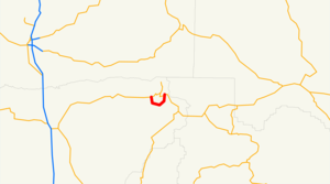
State Route 172 is a state highway in Tehama County, California, USA. It is a loop route off of State Route 36.
References
Wikimedia Foundation.
2010.
Look at other dictionaries:
California State Route 89 — State Route 89 Sierra Highway … Wikipedia
California State Route 58 — State Route 58 Route information … Wikipedia
California State Route 14 — Karte … Deutsch Wikipedia
California State Route 160 — State Route 160 North Sacramento Freeway, River Road … Wikipedia
California State Route 166 — State Route 166 Maricopa Highway … Wikipedia
California State Route 170 — Infobox road state=CA type=SR route=170 alternate name=Hollywood Freeway section=470 maint=Caltrans length mi=7.637 length round=3 length ref= length notes=(plus about 4 mi (6 km) on US 101) established=1964 direction a=South terminus a=jct|state … Wikipedia
California State Route 173 — Infobox road state=CA type=SR route=173 section=473 maint=Caltrans length mi=24.944 length round=3 length ref= direction a=West terminus a=jct|state=CA|SR|138 in Hesperia direction b=East terminus b=jct|state=CA|SR|18 near Lake Arrowhead previous … Wikipedia
Nevada State Route 206 — State Route 206 Foothill Road, Genoa Lane Route information Maintained by NDOT Length … Wikipedia
Arizona State Route 95 — Infobox road marker state=AZ highway name= name notes= type=state route=95 alternate name= maint=ADOT length mi=116.46 length round=2 length ref=cite web |url=http://tpd.az.gov/data/reports/2006SHSLog.pdf |title=2006 ADOT Highway Log… … Wikipedia
Route of the Lincoln Highway — The Lincoln Highway followed the following route:New YorkThe very short Lincoln Highway section in New York went west from Times Square on 42nd Street to the Weehawken Ferry. It was realigned down Broadway from which it turned right and passed… … Wikipedia
