- Arbet Kozhaya
Infobox City Lebanon
official_name = Arbet Kozhaya
native_name = عربة قزحيا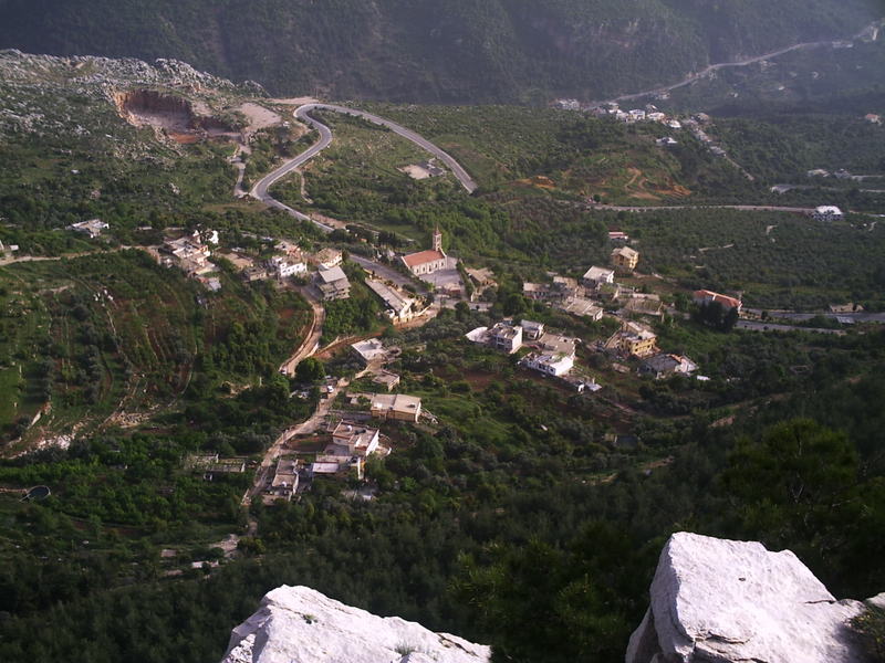
image_caption = Partial view of Arbet Kozhaya
governorate = North Governorate
district = Zgharta District
leader_title = President
leader_name = Badwi Jibrail Mansour
leader_title1 = Vice President
leader_name1 = Charbel Hanna Touma Boulos
leader_title2 = Mukhtar
leader_name2 = Antoine M. Bou Daher
leader_title3 = Council Members
leader_name3 = Joseph Elias Bechara
Michel Elias Ghassibeh
Mehsen Saadeh Mansour
Elias Edmond Sleiman
Antoun Badwi Yousuf
Mourad Elias Yousuf
Raymond Milad Yousuf
area_total_km2 = 2.0
elevation_m = 1000
lat_deg = 34
lat_min = 17
lat_sec = 42
lat_hem = N
lon_deg = 35
lon_min = 55
lon_sec = 32
lon_hem = E
mapx = 34.2950
mapy = 35.9256Arbet Kozhaya, also known as Arbet Qozhaya or Arabet Kozhaya, ( _ar. عربة قزحيا) is one of the fifty-six towns and villages, which make up the
Zgharta District ("Zgharta Zawie") in theNorth Governorate ofLebanon . [The village name is spelt as either Arbet Kozhaya or Arbet Qozhaya, depending on way theArabic name is transliterated. For this article we will keep to former spelling]Origin of the name
The village is named after the neighboring Monastery of Kozhaya, known as the Monastery of Saint
Anthony the Great ("Mar Antonios al-Kabir"). The monastery is some 950 metres above sea level in the Valley of Kozhaya.The word "Arbet" (Aarbet) means "inclined", since the village is on an inclined plane overlooking Kozhaya.
The name "Kozhaya" is
Syriac in origin and means "the treasure of life", with "treasure" representing "Christ ", for whom the monks of the Monastery abandon worldly goods and follow an ascetic life dedicated to prayer and spirituality; and "life" referring to the abundance of water endowing nature with life in the valley.Facts and figures
The Kozhaya Valley and the nearby Qannoubine Valley are part of the
Qadisha Valley , known also as the Holy Valley. The village lies between 900 and 1,050 metres above sea level and occupies some 2 million square metres, out of which approximatively 500,000 square metres are inhabited and 700,000 square metres under cultivation. It is at a distance of 5 Kilometres fromEhden , 25 Kilometres fromZgharta , 30 Kilometres from theCedars and 85 Kilometres fromBeirut .The village church is dedicated to Saint Elias and the Saint’s Feast day is celebrated on the 20th of July. There is a nearby hotel called [http://www.letournant.com Hôtel Le Tournant] , two small food shops and a medical centre built by the Fayez Mouawad Foundation. There is also a volley ball court built in the beginning of 1990’s by the late Francis Antoun. Freshwater is supplied to the village by two springs one being called "Al-Fas´in".The village has not had a school since the 1980’s. The first school opened in the mid 19th Century whose teachers were priests and monks from the Monastery of Saint
Anthony the Great . During the period, 1936 –1950, teachers included Kabalan Morcos El Douaihy, Tannous Bakhos, Raphael Khoury and Farid Attieh. The present generation of school children go to nearby schools at Al-Koura, technical college students going to local colleges in the region. Those attending university live away during term time.Population statistics
This article uses a study undertaken by Joseph El Homsy, who comes from the village. He conducted his study of the village in 2003, based on data for 2001-2002.
The study shows that the village population was recorded at 294 persons of whom 52.10 % were male and 46.90% were female. The average age was 32 years, with almost half the population under the age of 45.
Of the recorded 82 households in the study, 32 households lived elsewhere in Lebanon and 50 households lived permanently in the village. The study also showed that there were 44 families who emigrated up to 2002 and their destinations were: Australia 16; Canada 11; Venezuela 8; USA 4; France 3; Brazil 2.
Other sites show that in 1849, there were 179 males and 31 households. In 1988 there were 1,031 persons registered and in 1998 there were 977 persons registered. The official 2005 General Election registry for the village accounted for 720 registered voters (355 women and 365 men), including those living away but registered.
Municipal council
The village elects a municipal council returning nine members and an elected Mukhtar. The current Council’s members, elected in 2004 for a term of six years, are: Badwi Jibrail Mansour (President), Charbel Hanna Touma Boulos (Vice President), Joseph Elias Bechara, Michel Elias Ghassibeh, Mehsen Saadeh Mansour, Elias Edmond Sleiman, Antoun Badwi Yousuf, Mourad Elias Yousuf, Raymond Milad Yousuf. The elected Mukhtar is Antoine M. Bou Daher.
In 1998 the Council members, elected for a term of six years,included Michel S. Raffoul (President), Joseph Shehadeh (Vice President), Antoine Francis, Michel Ghassibeh, Mehsen Saadeh Mansour, Antoun Badwi Yousuf, Beshara Za'it. The elected Mukhtar was Antoine M. Bou Daher.
ee also
*Monastery of Saint Anthony of Qozhaya
*Toula ZghartaNotes
External links
* [http://www.arbet-kozhaya.com The official site of arbet-kozhaya village]
Wikimedia Foundation. 2010.