- Ohio State Route 82
-
State Route 82
Route information Maintained by ODOT Length: 88.76 mi[1] (142.85 km) Existed: 1924 – present Major junctions West end:  SR 57 near Elyria
 I-71 in Strongsville
 I-77 in Broadview Heights
 SR 11 near Niles
East end:  US 62/Trumbull CR 331 in Masury
Location Counties: Lorain, Cuyahoga, Summit, Portage, Trumbull Highway system Ohio highways
Interstates • U.S. Routes • State Routes←  SR 81
SR 81SR 83  →
→
State Route 82 is a state route in northeastern Ohio, with a western terminus at State Route 57 in Lorain County, southeast of Elyria. The route travels predominantly eastward through the southern suburbs of Cleveland as it traverses part of Lorain County, the southern tier of Cuyahoga County, the northern tier of Summit County, and enters Portage County. This segment of State Route 82 is very heavily traveled, and intersects with four interstate highways. Six-ramp interchanges join the route with Interstate 71 and Interstate 77, a partial interchange joins 82 with Interstate 271, and a diamond interchange intersects with Interstate 480/State Route 14. The route also passes through the Cuyahoga Valley National Park in Brecksville.
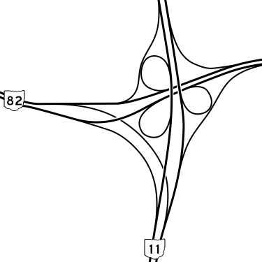
After passing through the northern tier of Portage County, State Route 82 crosses central Trumbull County, becoming a freeway for ten miles (16 km) along with State Route 5 as it bypasses the city of Warren. East of Warren, the route continues as a 4-lane divided highway, with level intersections at most secondary roads and interchanges with most other state highways, including a modified cloverleaf interchange with State Route 11. Just before the Pennsylvania state line, State Route 82 meets its eastern terminus with a full cloverleaf interchange in Masury at U.S. Route 62 and Trumbull CR 331 (Hubbard-Masury Road), which continues south.
Contents
Names
- Royalton Road, near Elyria, near Grafton, in Strongsville, North Royalton, and Broadview Heights.
- Chippewa Road in Brecksville
- Aurora Road in Macedonia and Twinsburg
- Twinsburg-Warren Road and Garfield East Road in Aurora
- State Street and Windham Street in Garrettsville[2]
History
The former alignment of State Route 82 in Trumbull followed Market Street through Warren (concurrent with State Route 5 to Elm Road), and then continued east on what is now Warren-Sharon Road through Howland, Vienna, and Brookfield Center. The former eastern terminus of the route was where Warren-Sharon Road meets the Pennsylvania state line, and State Street in Sharon, Pennsylvania continues east.
Junctions
County Location Mile Destinations Notes Lorain Carlisle Township 0.00 SR 57Western terminus of SR 82 (Grafton Road). Eaton Township 2.57 SR 83Avon-Belden Road Columbia Township 8.08  SR 252
East River Road Cuyahoga Strongsville 11.09  SR 237
Southern terminus of SR 237 (Prospect Road). 12.28  US 42
US 42Pearl Road 13.51 I-71North Royalton 17.63  SR 3
SR 3Ridge Road 18.16  SR 94
SR 94State Road Broadview Heights 22.12 I-77Junction with I-77 southbound. 22.14 I-77Junction with I-77 northbound. Brecksville 23.37  SR 21
SR 21Brecksville Road Summit Macedonia 29.07  SR 8
SR 825.59  I-271
I-271SR 82 only provides access to I-271 northbound. Twinsburg 32.81  I-480
I-480
 SR 14
SR 1433.41  SR 91
SR 91Darrow Road Portage Aurora 38.53  SR 43
SR 43Aurora Road 38.77  SR 306
Chillicothe Road Mantua Township 45.43  SR 44
SR 44Painesville-Ravenna Road Hiram 49.51  SR 700
 SR 305
Northern terminus of SR 700 concurrency (Garfield Road). Hiram Township 50.23 SR 700Southern terminus of SR 700 concurrency (Garfield Road). Garrettsville 52.86  SR 88
SR 88Northern terminus of SR 88 concurrency (North Street). 53.01 SR 88Southern terminus of SR 88 concurrency (South Street). Trumbull Braceville Township 60.30  SR 303
Eastern terminus of SR 303 (Hudson-Braceville Road). 60.50  SR 534
64.18  SR 5
SR 5Western southern terminus of SR 5 concurrency. Beginning of Warren Outerbelt. Bazetta Township 72.95 SR 5Eastern southern terminus of SR 5 concurrency. This is another southern terminus because of a highway off-ramp. Howland Township 76.94  SR 46
SR 46Niles-Cortland Road SE 78.62 SR 11Junction with SR 11 southbound. Vienna Township 78.66 SR 11Junction with SR 11 northbound. 81.01  SR 193
End of Warren Outerbelt (Youngstown-Kingsville Road SE). Brookfield Center 86.03  SR 7
SR 7Hubbard-Brookfield Road Masury 88.76 US 62Eastern terminus of SR 82. 1.000 mi = 1.609 km; 1.000 km = 0.621 mi References
- ^ Ohio Department of Transportation. "Technical Services Straight Line Diagrams". http://www.odotonline.org/techservapps/SLD/default.htm. Retrieved 2010-04-30.
- ^ Google, Inc. Google Maps – Google map of Garrettsville, Ohio (Map). Cartography by Google, Inc. http://maps.google.com/maps?q=Garrettsville,+OH,+USA&sa=X&oi=map&ct=image. Retrieved June 8, 2009.
External links
Categories:- State highways in Ohio
- Transportation in Lorain County, Ohio
- Transportation in Portage County, Ohio
- Transportation in Trumbull County, Ohio
- Transportation in Summit County, Ohio
- Transportation in Cuyahoga County, Ohio

Wikimedia Foundation. 2010.