- New York State Route 214
-
NYS Route 214
Route information Maintained by NYSDOT Length: 12.48 mi[2] (20.08 km) Existed: 1930[1] – present Major junctions South end:  NY 28 in Shandaken
North end:  NY 23A near Tannersville
Location Counties: Ulster, Greene Highway system Numbered highways in New York
Interstate • U.S. • N.Y. (former) • Reference • County←  NY 213
NY 215  →
→New York State Route 214 (NY 214) is a short but scenic state highway in the heart of the Catskill Park. It runs north–south from near the hamlet of Phoenicia up near an old railroad route into the narrow pass known as Stony Clove Notch, then down into the upper Schoharie Creek valley to end near Hunter.
Contents
Route description
 NY 214 looking north into Stony Clove Notch
214 leaves 28 just before a bridge over Esopus Creek outside downtown Phoenicia. Like 28, it bypasses the small commercial district to immediately follow Stony Clove Creek north, curving and ascending gradually but steadily as it does so. The road follows the old path of the Stony Clove and Catskill Mountain Railroad, which used narrow-gauge tracks to conquer the mountains here. At the hamlet of Chichester a few miles north, the deep setback of the few houses along the east side of the road reflects this onetime dominance of the tracks.
Somewhere in this area, according to local legend, notorious gangster Dutch Schultz, who often came to the area on weekends when he was running rackets in nearby Hudson, secreted a considerable amount of his loot. The map to the site was supposedly destroyed by a hit man who didn't believe it to be real. Although some treasure hunters have come to the area from time to time, it has never been found.
Chichester, Lanesville and Edgewood, across the county line, were lumber centers in the late 19th and early 20th centuries — Chichester in particular was noted for chairs made locally. Today, with much of the surrounding woods part of New York State's Forest Preserve, that industry is part of the past and the two remain small, quiet hamlets.
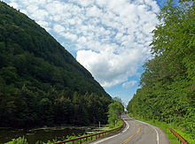
 NY 214 heading southbound from NY 23A facing Hunter Mountain
North of Lanesville the road continues to climb, and Southwest Hunter Mountain, one of the Catskill High Peaks, can be seen ahead at some points to the northwest. At Stony Clove Creek Road, the Long Path hiking trail's aqua blazes on telephone poles indicate that it joins the road for the final climb into the notch. The road begins to level off in some swampy areas as it passes Devil's Tombstone State Campground. Ahead, the notch, the dramatic gap between Plateau and Hunter mountains, becomes imminent.The notch is marked by a small parking lot (a fee is charged in summertime, since it is part of the nearby campground) and Notch Pond to the west of the road. The Long Path leaves the road and joins the Devil's Path hiking trail here.
At the top of the notch, 214 reaches approximately 2,220 feet (677 m) in elevation, making it one of the highest roads in the state. There is just enough space between the steep, towering slopes of both mountains for the road (and before it was built, there was even less), the sole barrier between the Indian Head Wilderness Area on the east and what is currently the Hunter Mountain Wild Forest to the west. Past the notch, the road's northern end two miles (3 km) away is visible as it gently descends into the Schoharie Valley and reaches NY 23A at a quiet junction between Hunter and Tannersville.
History
 NY 214 approaching its northern terminus with NY 23A in Hunter
A track of some kind had long existed up 214's present-day course, although it was suitable only for personal foot traffic, which had to pass through Stony Clove Notch in single file as it was extremely narrow at the time. In the 1840s tanner Charles Edwards widened it at great personal expense so that at least wagons could get through, serving not only his tanneries in Hunter but the lumber companies in Lanesville and Chichester as well.
In 1873 the Stoney [sic] Clove Turnpike was incorporated to make further road improvements. In 1881, the narrow gauge railway was built along the road. The road was taken over by the state of New York in the late 1920s and designated as NY 214 as part of the 1930 renumbering of state highways in New York.[1][3]
Major intersections
County Location Mile[2] Destinations Notes Ulster Shandaken 0.00 NY 28Hamlet of Phoenicia Greene Town of Hunter 12.48 NY 23A1.000 mi = 1.609 km; 1.000 km = 0.621 mi References
- ^ a b Standard Oil Company of New York (1930). Road Map of New York (Map). Cartography by General Drafting.
- ^ a b "2008 Traffic Volume Report for New York State" (PDF). New York State Department of Transportation. June 16, 2009. p. 189. https://www.nysdot.gov/divisions/engineering/technical-services/hds-respository/NYSDOT%20TVR%202008%20by%20Route.pdf. Retrieved February 1, 2010.
- ^ State of New York Department of Public Works (1926). Official Map Showing State Highways and other important roads (Map). Cartography by Rand McNally and Company.
External links
Categories:- State highways in New York
- Catskills
- Transportation in Ulster County, New York
- Transportation in Greene County, New York


Wikimedia Foundation. 2010.