- Dark Canyon Wilderness
-
Dark Canyon Wilderness IUCN Category Ib (Wilderness Area)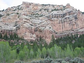
Location San Juan County, Utah, USA Nearest city Monticello, Utah Coordinates 37°46′35″N 109°53′51″W / 37.7763793°N 109.8976330°WCoordinates: 37°46′35″N 109°53′51″W / 37.7763793°N 109.8976330°W [1] Area 47,116 acres (19,067 ha) Established September 18, 1984 Governing body U.S. Forest Service 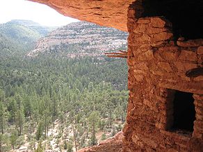 Ancestral Puebloan ruin in Dark Canyon Wilderness
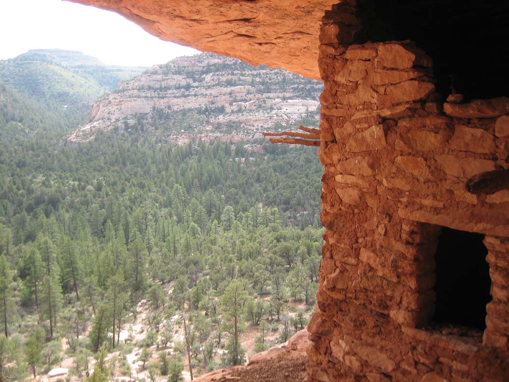
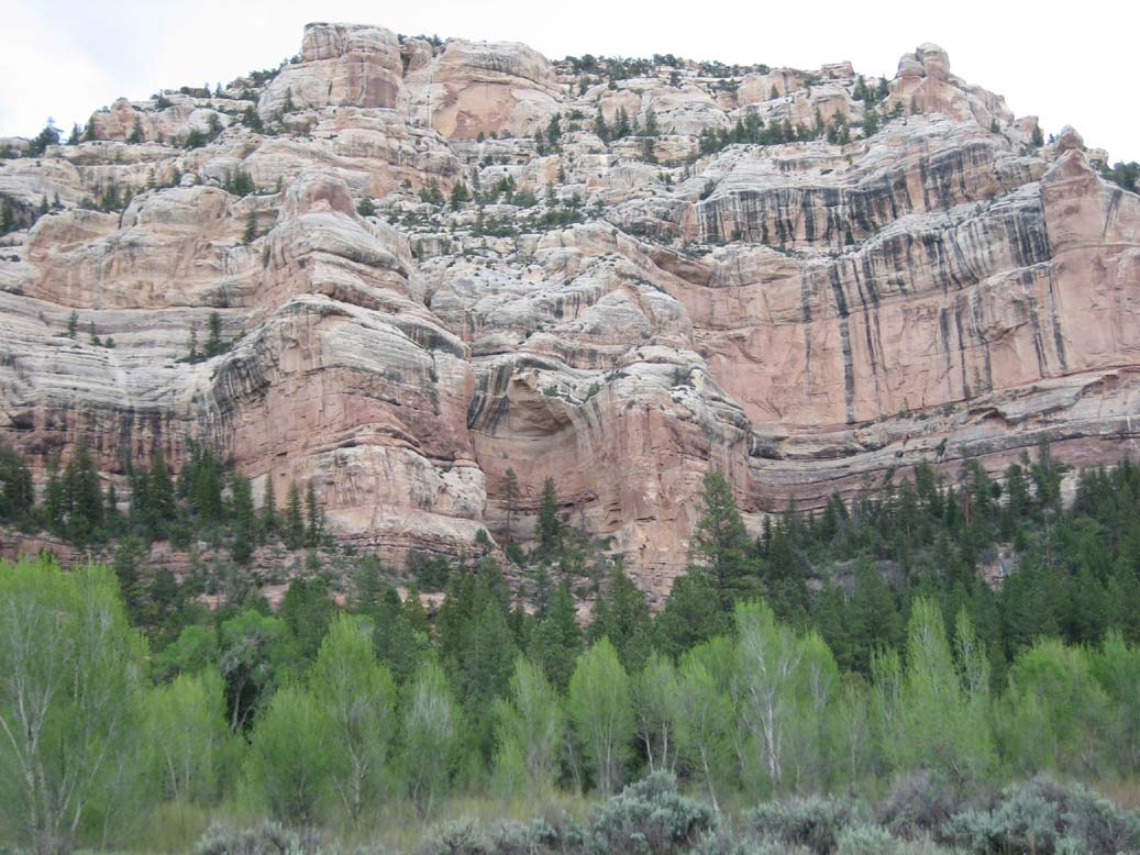
Dark Canyon Wilderness, in the heart of southeast Utah's canyon country, is named for its high steep walls that narrow in the lower section so that they block the light in the morning and late afternoon. The roughly horseshoe-shaped wilderness is made up of the upper part of 40-mile (64 km) long Dark Canyon and two major tributaries, Woodenshoe Canyon and Peavine Canyon in the Manti-La Sal National Forest. These canyons all descend from pine-covered Elk Ridge northeast of Natural Bridges National Monument. Dark Canyon continues west within a U.S. Bureau of Land Management primitive area that is recommended for wilderness designation. The last four miles of the main canyon drop steeply through Glen Canyon National Recreation Area into Lake Powell.
Life zones range from ponderosa pine and aspen-covered high country to desert vegetation in the bottom of Dark Canyon. High terraced castle-like sandstone walls tower 3,000 feet (910 m) above the canyon floors. Wildlife species include mule deer, some mountain lions, black bear and bighorn sheep. This diverse canyon country contains arches, springs, seeps and hanging gardens.
Water sources in Dark Canyon are often widely separated, and some have dried up entirely in recent drought years. Thunderstorms can result in powerful flash floods that scour the canyon streambeds.
Wilderness visitors may see evidence of the Ancestral Puebloan culture.
All the trails dropping into the canyons are moderate but they can be difficult, if not impossible, to find and follow until you reach the bottoms of the canyons. Peavine Canyon contains a cherry-stem jeep trail. The Forest Service once recommended closing the area to vehicles but this corridor was kept open as a compromise in the Utah Wilderness Act of 1984.
See also
References
External links
- "Dark Canyon Wilderness". The National Wilderness Preservation System. Wilderness.net. http://www.wilderness.net/index.cfm?fuse=NWPS&sec=wildView&wname=Dark%20Canyon. Retrieved 2008-11-27.
Protected Areas of Utah Federal National ParksNational MonumentsNational Historic SitesDesert Biosphere Reserve • Flaming Gorge National Recreation Area • Glen Canyon National Recreation Area • Mormon Pioneer National Historic TrailNational Wildlife Refuges:Bear River Migratory Bird Refuge • Fish Springs • OurayAshdown Gorge • Beartrap Canyon • Beaver Dam Mountains • Black Ridge Canyons • Blackridge • Box-Death Hollow • Canaan Mountain • Cedar Mountain • Cottonwood Canyon • Cottonwood Forest • Cougar Canyon • Dark Canyon • Deep Creek • Deep Creek North • Deseret Peak • Doc's Pass • Goose Creek • High Uintas • LaVerkin Creek • Lone Peak • Mount Naomi • Mount Nebo • Mount Olympus • Mount Timpanogos • Paria Canyon-Vermilion Cliffs • Pine Valley Mountain • Red Mountains • Slaughter Creek • Taylor Creek • Twin Peaks • Wellsville Mountain • Zion
State Antelope Island • Bear Lake • Camp Floyd • Deer Creek • East Canyon • Flight Park • Great Salt Lake • Historic Rail Trail • Hyrum • Jordan River OHV Park • Jordanelle • Red Fleet • Rockport • Starvation • Steinaker • Utah Field House • Utah Lake • Wasatch Mountain • Willard Bay
Fremont Indian • Goblin Valley • Green River • Huntington • Millsite • Palisade • Scofield • Territorial Statehouse • Yuba
Anasazi • Coral Pink Sand Dunes • Dead Horse Point • Edge of the Cedars • Escalante Petrified Forest • Frontier Homestead • Goosenecks • Gunlock • Kodachrome Basin • Otter Creek • Piute • Quail Creek • Sand Hollow • Snow Canyon
Municipal Municipal parksFort Buenaventura • Gallivan Center • Liberty Park • Jordan River Parkway • Minersville Reservoir • Murray City Park • Sugar House Park • Veterans Memorial Park
Utah State Parks and Recreation Categories:- IUCN Category Ib
- Wilderness Areas of Utah
- Protected areas of San Juan County, Utah
- Native American history of Utah
- Native American archeology
- Pre-Columbian cultural areas
- Bureau of Land Management areas in Utah
Wikimedia Foundation. 2010.