- Karacabey
-
For the horse breed, see Karacabey (horse).
Karacabey is a town and district of Bursa Province in the Marmara region of Turkey. It is located just west of the Simav River near its confluence with the [[]].
Karacabey is an industrial area as well as an agricultural one. It is known as the plantation area of a special variety of onions. There are many famous food factories around Karacabey such as Nestle and many varieties of vegetables and fruits are planted in Karacabey. There is a lake near it called Uluabat. The Marmara Sea is 32 km north.
The town is named for a soldier during the Ottoman Empire Era. The former name of the town was Mikalick[1] (Turkish: Mihaliç), after which a cheese was named, while its ancient name was Miletopolis (Greek: Μιλητόπολις). Miletopolis was apparently the chief settlement of a people called the Milatæ, whose name was hellenized to suggest a Milesian colony. Its people colonized Gargara.[2]
Miletopolis was a suffragan of Cyzicus until the 12th or 13th century. Around the end of the twelfth, it united with Lopadium as an archbishopric.[2] There are two historical mosques in Karacabey, one from the 14th century.
See also
References
- ^ Hazlitt, Wm. The Classical Gazetteer: A Dictionary of Ancient Geography, Sacred and Profane. "Macestus." Whittaker & Co. (London), 1851. Accessed 4 Sept 2011.
- ^ a b Pétridès, S. The Catholic Encyclopedia. "Miletopolis." Robert Appleton Company (New York), 1911. Accessed 4 Sept 2011.
 Karacabey in Bursa Province (in the Marmara region) of Turkey
Urban districts 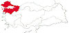
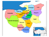
Rural districts Büyükorhan - Harmancık - İnegöl - İznik - Karacabey - Keles - Mustafakemalpaşa - Orhaneli - Orhangazi - YenişehirRegionsAegean Black Sea Central Anatolia Eastern Anatolia Marmara Mediterranean Southeastern Anatolia Categories:- Districts of Bursa
- Marmara Region
- Populated places in Bursa Province
- Milesian colonies
- Marmara Region geography stubs

Wikimedia Foundation. 2010.