- Mitaka, Tokyo
-
Mitaka
三鷹市— City — 
FlagLocation of Mitaka in Tokyo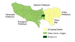

 Mitaka
Coordinates: 35°41′N 139°34′E / 35.683°N 139.567°ECoordinates: 35°41′N 139°34′E / 35.683°N 139.567°E Country Japan Region Kantō Prefecture Tokyo Government - Mayor Keiko Kiyohara (since April 2003) Area - Total 16.50 km2 (6.4 sq mi) Population (November 1, 2010) - Total 176,737 - Density 10,711.33/km2 (27,742.2/sq mi) Time zone Japan Standard Time (UTC+9) City symbols - Tree Ginkgo biloba - Flower Malus halliana Phone number 81(0)422-45-1151 Address Nozaki 1-1-1, Mitaka City, Tokyo (東京都三鷹市野崎1丁目1番1号)
181-8555Website Mitaka 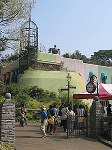
Mitaka (三鷹市 Mitaka-shi) is a city located in Tokyo, Japan. As of 1 November 2010, the city has an estimated population of 176,737.[1] The total area is 16.50 km² and is about 50 – 55 meters above sea level.[2] Mitaka City was officially founded on November 3, 1950, though settlement on its site can be traced back as far as 1590.
The Tamagawa Josui Canal, which runs alongside Mitaka station, has an important place in history, built in 1653 to feed the local metropolis. It is also the place where novelist Osamu Dazai committed suicide in 1948. The National Astronomical Observatory of Japan is located in Mitaka.
Mitaka is home to the Ghibli Museum, which is located in Inokashira Park, a popular destination in its own right, especially during spring cherry blossom viewing season.
Contents
Education
Colleges and universities
- Graduate University for Advanced Studies - Department of Astronomical Science, School of Physical Sciences
- International Christian University - Japan's oldest and largest United States style university, founded on June 15, 1949.
- Japan Lutheran College
- Kyorin University - School of Medicine, Kyorin University Hospital and Nursing School
- Tokyo Union Theological Seminary
- University of Tokyo - the Institute of Astronomy, Faculty of Science
Primary and secondary schools
Public elementary and junior high schools are operated by Mitaka. Mitaka High School ([1] JA) is operated by the Tokyo Metropolitan Government Board of Education.
Economy
Studio Pierrot has its corporate headquarters in Mitaka.[3]
Geography
Mitaka is located on the Kantō Plain, just outside the 23 Central Wards of metropolitan Tokyo, which are on its eastern borders. It is bordered by the cities of Musashino to the north, Chōfu to the south, and Koganei to the west.
See also
References
- ^ Mitaka city | population of Mitaka city
- ^ Mitaka city | location of Mitaka city
- ^ "Company Profile." Studio Pierrot. Retrieved on February 26, 2010.
External links
- Mitaka official website (English)
- Mitaka official website (Japanese)
Tokyo Metropolis Architecture · Education · Festivals · History · Politics · Sports · Tourism · Transportation Special Wards 

Cities Akiruno · Akishima · Chōfu · Fuchū · Fussa · Hachiōji · Hamura · Higashikurume · Higashimurayama · Higashiyamato · Hino · Inagi · Kiyose · Kodaira · Koganei · Kokubunji · Komae · Kunitachi · Machida · Mitaka · Musashimurayama · Musashino · Nishitōkyō · Ōme · Tachikawa · Tama
Districts and
SubprefecturesPortal · Category Categories:- Cities in Tokyo
- Western Tokyo
- Tokyo geography stubs


Wikimedia Foundation. 2010.