- Malá Fatra National Park
-
Malá Fatra National Park
Národný park Malá FatraIUCN Category II (National Park)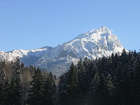
Veľký Rozsutec (1,610 m)Location West Slovakia Coordinates 49°12′50″N 19°04′51″E / 49.213969°N 19.080785°ECoordinates: 49°12′50″N 19°04′51″E / 49.213969°N 19.080785°E Area 226.3 km² (87.37 mi²) Established 1 April 1988 Governing body Správa Národného parku Malá Fatra (Malá Fatra National Park administration) The Malá Fatra National Park (Slovak: Národný park Malá Fatra) is a national park in the northern part of the Malá Fatra mountains called Krivánska Malá Fatra.
It has an area of 226.3 km² (87.37 mi²) and a 232.62 km² (89.81 mi²) buffer zone. The park was declared in 1988. Between 1967 and 1988 it was a protected landscape area.
For a geological and geographical description see Malá Fatra.
Contents
Flora
The mountain is covered mainly with mixed beech forests, at higher elevations with fir and spruce. Pine woods and meadows occur at higher altitudes. About 83% of the area is covered in forest.
In the variety and beauty of flora species, the following examples stand out as the most remarkable:
- gentian (Gentiana clusii)
- auricula (Primula auricula)
- Dianthus nitidus
- round-leaved sundew (Drosera rotundifolia)
- lady's slipper orchid (Cypripedium calceolus).
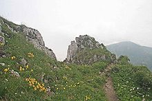 The summit of Malý Kriváň (1,671 m) in the foreground
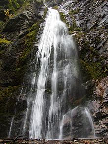 Šútovo Waterfall
Fauna
The fauna includes:
- golden eagle (Aquila chrysaetos),
- eagle-owl (Bubo bubo)
- black stork (Ciconia nigra)
- brown bear (Ursus arctos)
- lynx (Lynx lynx)
- Beech Marten (Martes foina)
- European Otter (Lutra lutra)
- wildcat (Felis silvestris)
- Grey Wolf (Canis lupus).
Remarkable places
- Kryštálová jaskyňa (Crystal Cave) with calcite decoration, located in the Malý Rozsutec Mountain
- the 38 metres high Šútovo Waterfall
- castles, such as the Strečno Castle and Starhrad
- traditional architecture: Štefanová and Podšíp settlements
- Slovak folklore centres, such as the village of Terchová
See also
- Protected areas of Slovakia
External links
National parks and protected landscape areas of Slovakia National parks Low Tatras • Malá Fatra • Muránska planina • Pieniny • Poloniny • Slovak Karst • Slovak Paradise • Tatra National Park • Veľká FatraProtected landscape areas Categories:- IUCN Category II
- National parks of Slovakia
- Protected areas established in 1988
- Protected areas of the Western Carpathians


Wikimedia Foundation. 2010.