- Normanton, Pontefract and Castleford (UK Parliament constituency)
-
Coordinates: 53°43′01″N 1°21′40″W / 53.717°N 1.361°W
Normanton, Pontefract and Castleford County constituency for the House of Commons 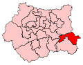
Boundary of Normanton, Pontefract and Castleford in West Yorkshire.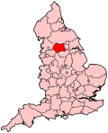
Location of West Yorkshire within England.County West Yorkshire Electorate 83,284 (December 2010)[1] Current constituency Created 2010 Member of Parliament Yvette Cooper (Labour) Number of members One Created from Pontefract and Castleford, Normanton Overlaps European Parliament constituency Yorkshire and the Humber Normanton, Pontefract and Castleford is a county constituency represented in the House of Commons of the Parliament of the United Kingdom. It elects one Member of Parliament (MP) by the first past the post system of election.
Contents
Boundaries
Following their review of parliamentary representation in West Yorkshire, the Boundary Commission for England has recommended the creation of a new seat of Normanton, Pontefract and Castleford, taking the Normanton, Castleford and Pontefract towns from the district of Wakefield. Due to population decline, the Commission had to reduce the constituencies of the county by one, resulting in the "merger" of Normanton and Pontefract/Castleford seats.
The electoral wards used in the formation of this constituency, which was first fought at the 2010 general election are:
- Airedale and Ferry Fryston, Altofts and Whitwood, Castleford Central and Glasshoughton, Knottingley, Normanton, Pontefract North, and Pontefract South
The Commission had great difficulty in naming the constituency, with "Normanton and Pontefract" and "Pontefract and Castleford" both suggested. On May 24, 2006 the modified name was chosen following further public consultation.
Members of Parliament
Election Member [2] Party 2010 Yvette Cooper Labour Election Results
Election Political result Candidate Party Votes % ±% General Election 2010
Electorate: 83,284
Turnout: 46,239 (56.2%) +2.9Labour hold
Majority: 10,979 (23.7%)
Swing: -12.5% from Lab to ConYvette Cooper Labour 22,293 48.1 -17.1 Nick Pickles Conservative 11,314 24.4 +7.9 Chris Rush Liberal Democrat 7,585 16.4 +5.3 Graham Thewlis-Hardy BNP 3,846 8.3 +4.4 Gareth Allen Independent 1,183 2.6 N/A See also
Notes and references
- ^ "Electorate Figures - Boundary Commission for England". 2011 Electorate Figures. Boundary Commission for England. 4 March 2011. http://www.boundarycommissionforengland.org.uk/electoral-figures/electoral-figures.htm. Retrieved 13 March 2011.
- ^ Leigh Rayment's Historical List of MPs – Constituencies beginning with "N" (part 2)
Categories:- Politics of Wakefield
- Parliamentary constituencies in Yorkshire and the Humber
- United Kingdom Parliamentary constituencies established in 2010


Wikimedia Foundation. 2010.