Oregon Route 104

Oregon Route 104

Oregon Route 104 marker

Oregon Route 104
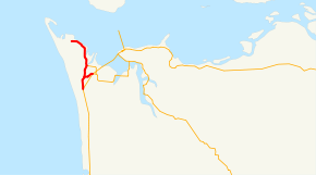
Route information
Maintained by ODOT
Length: 6.04 mi (9.72 km)
Existed: 2002 – present
Major junctions
South end: US 101.svg US 101 in Warrenton
  OR 104S.svg OR 104 Spur in Warrenton
US 101.svg US 101 Business in Warrenton
North end: Fort Stevens State Park at Warrenton
Highway system

Oregon highways
Routes • Highways

OR 103 OR 104S

Oregon Route 104, known as the Fort Stevens Highway No. 104 (see Oregon highways and routes), is an Oregon state highway which connects US 101 near Warrenton with Fort Stevens State Park.

The OR 104 designation was applied to the Fort Stevens Highway in 2002 as part of Oregon's project to assign route numbers to previously unrouted highways.

Route description

The southern terminus of OR 104 is at a junction with US 101 near south of Warrenton. It heads due north for 6 miles (9.7 km), ending at the entrance to Fort Stevens State Park near Hammond. The southern portion of the route, and its spur constitute an old portion of US 101.

Oregon Route 104S

Oregon Route 104S is a spur route of Oregon Route 104, and connects OR 104 to U.S. Route 101 and U.S. Route 101 Business in Warrenton. The route is designated as the Fort Stevens Spur of the Fort Stevens Highway No. 104.

External links


Wikimedia Foundation. 2010.

Игры ⚽ Поможем решить контрольную работу

Look at other dictionaries:

  • Oregon Route 104S — Infobox road state=OR type=OR route=104S length mi=0.88 length km=1.42 direction a=West starting terminus= direction b=East ending terminus= established=2002 previous type=OR previous route=104 next type=Interstate next route=105Oregon Route 104S …   Wikipedia

  • Oregon Route 103 — Route information Maintained b …   Wikipedia

  • Oregon Route 62 — For the unsigned Highway 62, see Florence Eugene Highway. Oregon Route 62 Route information …   Wikipedia

  • List of highways numbered 104 — Route 104, or Highway 104, can refer to: For a list of road designated A104, see List of A104 roads. Contents 1 Canada 2 China 3 Japan 4 United States …   Wikipedia

  • Oregon Caves National Monument — Coordinates: 42°05′44″N 123°24′21″W / 42.09556°N 123.40583°W / 42.09556; 123.40583 …   Wikipedia

  • Oregon's 3rd congressional district — OR 3 redirects here. OR 3 may also refer to Oregon Route 3. Oregon s 3rd congressional district District map since 2002 Current Representative Earl Blumenauer ( …   Wikipedia

  • U.S. Route 101 in Oregon — This article is about the section of U.S. Route 101 in Oregon. For the entire length of the highway, see U.S. Route 101. U.S. Route 101 …   Wikipedia

  • Oregon Country — Map of Oregon Country The Oregon Country was a predominantly American term referring to a disputed ownership region of the Pacific Northwest of North America. The region was occupied by British and French Canadian fur traders from before 1810,… …   Wikipedia

  • Eugene, Oregon — City of Eugene   City   The Wayne L. Morse Federal Courthouse …   Wikipedia

  • U.S. Route 30 in Oregon — For the unsigned Highway 30, see Willamina Salem Highway. This article is about the section of U.S. Route 30 in Oregon. For the entire length of the highway, see U.S. Route 30. U.S. Route 30 …   Wikipedia

Share the article and excerpts

Direct link
Do a right-click on the link above
and select “Copy Link”