- Cherry Capital Airport
-
Cherry Capital Airport 
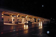
Cherry Capital Airport terminal IATA: TVC – ICAO: KTVC – FAA LID: TVC Summary Airport type Public Owner Grand Traverse & Leelanau Counties Serves Traverse City, Michigan Elevation AMSL 624 ft / 190 m Coordinates 44°44′30″N 085°34′56″W / 44.74167°N 85.58222°WCoordinates: 44°44′30″N 085°34′56″W / 44.74167°N 85.58222°W Website Maps FAA airport diagram Location of airport in Michigan
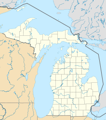
 TVC
TVCRunways Direction Length Surface ft m 10/28 6,500 1,981 Asphalt 18/36 5,378 1,639 Asphalt Statistics (2010) Total passengers (MDOT) 343,679  4%
4%Total enplanements (FAA) 167,488 5%Aircraft operations (2009) 76,464 17%Based aircraft (2009) 97 Sources: FAA[1][2] and MDOT[3][4] Cherry Capital Airport (IATA: TVC, ICAO: KTVC, FAA LID: TVC) is a public-use airport located two nautical miles (4 km) south of the central business district of Traverse City, in Grand Traverse County, Michigan, United States. It is owned by Grand Traverse and Leelanau counties.[1]
This airport is included in the National Plan of Integrated Airport Systems for 2011–2015, which categorized it as a primary commercial service airport (more than 10,000 enplanements per year).[5] As per Federal Aviation Administration records, the airport had 167,488 passenger boardings (enplanements) in calendar year 2010, a decrease of 4.67% from the 175,692 enplanements in 2009.[2]
As per the Michigan Department of Transportation, this airport had 343,679 total passengers (enplanements and deplanements) in 2010,[3] a decrease of 3.99% from 357,955 total passengers in 2009.[4]
Contents
History
In the fall of 2004, Cherry Capital opened a new terminal. Since then, Cherry Capital Airport has continued to grow with various carriers adding seasonal service and destinations.[6]
Cherry Capital Airport was the recipient of the 2003–2004, 2004–2005, and 2005–2006 Balchen/Post Awards for outstanding achievement in snow and ice control in the small commercial service airport category.[7][8][9]
Soon,[when?] the airport will implement the first biometric access systems in the country.[6] The airport is the ninth to implement the advanced security measures suggested after the September 11, 2001, attacks.[6] This terminal is able to comply better with security regulations and supports a greater number of flights and passengers.
Facilities and aircraft
Cherry Capital Airport covers an area of 1,026 acres (415 ha) at an elevation of 624 feet (190 m) above mean sea level. It has two asphalt paved runways: 10/28 is 6,500 by 150 feet (1,981 x 46 m) and 18/36 is 5,378 by 150 feet (1,639 x 46 m).[1]
For the 12-month period ending December 31, 2009, the airport had 76,464 aircraft operations (down from 92,483 in 2008), an average of 209 per day: 74% general aviation, 13% military, 12% scheduled commercial, and 1% air taxi. At that time there were 97 aircraft based at this airport: 72% single-engine, 18% multi-engine, 4% jet, and 6% helicopter.[1]
In February 2009, Forbes magazine ranked Cherry Capital Airport second in their list of the top ten "rip-off" airports in the United States, citing an average cost per mile to travelers departing TVC of 41 cents.[10]
Airlines and destinations
The following passenger airlines provide scheduled service to and from Cherry Capital Airport:
Airlines Destinations American Eagle Chicago-O'Hare, Marquette
Seasonal: New York-LaGuardiaDelta Air Lines Seasonal: Detroit, Minneapolis/St. Paul Delta Connection operated by Comair Seasonal: Detroit Delta Connection operated by Mesaba Airlines Detroit Delta Connection operated by Pinnacle Airlines Detroit
Seasonal: New York-LaGuardiaUnited Express operated by ExpressJet Airlines Chicago-O'Hare United Express operated by SkyWest Airlines Chicago-O'Hare
Seasonal: Denver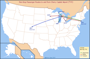

Airlines and destinations served from Traverse City (as of June 2010[update]) Accidents and incidents
- Northwest Airlink Flight 4712 (operated by Pinnacle Airlines) was a Bombardier CRJ200 from Minneapolis-St. Paul "which overran the runway while landing at TVC during a snowstorm on April 12, 2007. The aircraft received substantial damage, but the 52 people on board were not injured. The Board determined that the probable cause of this accident was the pilots’ decision to land at TVC without performing a landing distance assessment, which was required by company policy. This poor decision-making likely reflected the effects of fatigue produced by a long, demanding duty day, and, for the captain, the duties associated with check airman functions. Contributing to the accident were 1) the Federal Aviation Administration pilot flight and duty time regulations that permitted the pilots’ long, demanding duty day and 2) the TVC operations supervisor’s use of ambiguous and unspecific radio phraseology in providing runway braking information. Four safety recommendations were issued to the FAA addressing timely post accident drug testing, training on landing distance assessment performance, ground operations personnel communications, and criteria for runway closures in snow and ice conditions. The NTSB adopted the report on June 10, 2008."[11]
References
- ^ a b c d FAA Airport Master Record for TVC (Form 5010 PDF). Federal Aviation Administration. 25 August 2011.
- ^ a b "Primary, Non-primary Commercial Service, and General Aviation Airports (by State) (PDF, 5.4 MB)". CY 2010 Passenger Boarding and All-Cargo Data. Federal Aviation Administration. 4 October 2011. http://www.faa.gov/airports/planning_capacity/passenger_allcargo_stats/passenger/media/cy10_all_enplanements.pdf.
- ^ a b "Total Scheduled Passengers 2010". Measures of Michigan Air Carrier Demand. Michigan Department of Transportation. http://mdotwas1.mdot.state.mi.us/public/airportstats/srchpic2.cfm?syr=2010&rtype=9. Retrieved 25 October 2011.
- ^ a b "Total Scheduled Passengers 2009". Measures of Michigan Air Carrier Demand. Michigan Department of Transportation. http://mdotwas1.mdot.state.mi.us/public/airportstats/srchpic2.cfm?syr=2009&rtype=9. Retrieved 25 October 2011.
- ^ "2011–2015 NPIAS Report, Appendix A (PDF, 2.03 MB)". 2011–2015 National Plan of Integrated Airport Systems. Federal Aviation Administration. 4 October 2010. http://www.faa.gov/airports/planning_capacity/npias/reports/media/2011/npias_2011_appA.pdf.
- ^ a b c "New State-of-the-Art Terminal". Cherry Capital Airport. Archived from the original on 28 September 2007. http://web.archive.org/web/20070928124940/http://www.tvcairport.com/terminal.htm.
- ^ "2003 – 2004 Balchen/Post Awards". Northeast Chapter American Association of Airport Executives. 12 May 2004. http://www.necaaae.org/cfiles/ne_balchen_03_04.php. Retrieved 6 June 2011.
- ^ "2004 – 2005 Balchen/Post Awards". Northeast Chapter American Association of Airport Executives. 27 April 2005. http://www.necaaae.org/cfiles/ne_balchen_04_05.php. Retrieved 6 June 2011.
- ^ "2005 – 2006 Balchen/Post Awards". Northeast Chapter American Association of Airport Executives. 26 April 2006. http://www.necaaae.org/cfiles/ne_balchen_05_06.php. Retrieved 6 June 2011.
- ^ "America's Rip-Off Airports". Forbes.com. 16 February 2009. http://www.forbes.com/2009/02/15/airports-travel-regional-lifestyle-travel_0216_airports.html.
- ^ "2008 Annual Report to Congress". National Transportation Safety Board. Archived from the original on 14 August 2009. http://web.archive.org/web/20090814010612/http://ntsb.gov/publictn/2009/SPC0901.pdf.
External links
- Official website
- Traverse City, Cherry Captial (TVC) page from Michigan Bureau of Aeronautics
- KTVC Forums[dead link]
- Aviation photos: Traverse City - Cherry Capital (Municipal) (TVC / KTVC) from Airliners.net
- Aerial image as of 27 April 1998 from USGS The National Map
- FAA Airport Diagram (PDF), effective 20 October 2011
- FAA Terminal Procedures for TVC, effective 20 October 2011
- Resources for this airport:
- AirNav airport information for KTVC
- ASN accident history for TVC
- FlightAware airport information and live flight tracker
- NOAA/NWS latest weather observations
- SkyVector aeronautical chart for KTVC
- FAA current TVC delay information
Categories:- Airports in Michigan
- Buildings and structures in Grand Traverse County, Michigan
- Transportation in Grand Traverse County, Michigan
- Traverse City, Michigan


Wikimedia Foundation. 2010.