- Hidaka Mountains
Geobox|Range
name = Hidaka Mountains
native_name = 日高山脈 "hidaka-sanmyaku"
other_name =
category =
etymology = sun high
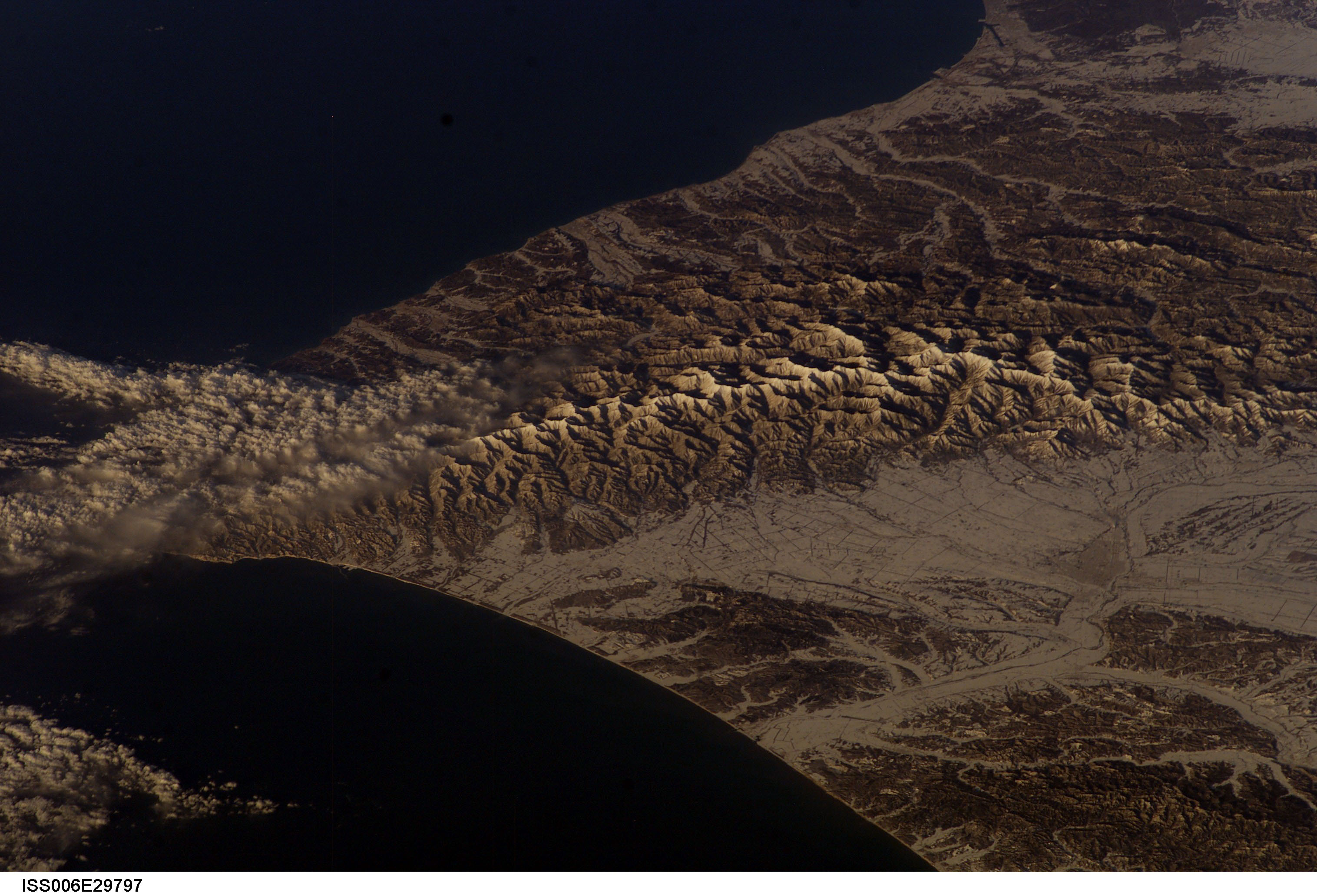
image_caption = Mountains, taken from the ISS on Feb. 22, 2003
country = Japan
state = Hokkaidō
region = Hidaka Subprefecture
region1 = Tokachi Subprefecture
district = Hidaka District, Hokkaidō
district1 = Hiroo District, Hokkaidō
district2 = Horoizumi District, Hokkaidō
district3 = Kamikawa (Tokachi) District, Hokkaidō
district4 = Kasai District, Hokkaidō
district5 = Niikappu District, Hokkaidō
district6 = Samani District, Hokkaidō
district7 = Saru District, Hokkaidō
district8 = Urakawa District, Hokkaidō
municipality = Obihiro, Hokkaidō
range = Hidaka
border =
part =
city =
landmark =
river =
highest = Mount Poroshiri
highest_location = | highest_region = | highest_country =
highest_elevation = 2052.4
highest_lat_d = 42| highest_lat_m = 43| highest_lat_s = 9| highest_lat_NS = N
highest_long_d = 142| highest_long_m = 40| highest_long_s = 58| highest_long_EW = E
lowest =
lowest_location = | lowest_region = | lowest_country =
lowest_elevation =
lowest_lat_d = | lowest_lat_m = | lowest_lat_s = | lowest_lat_NS =
lowest_long_d = | lowest_long_m = | lowest_long_s = | lowest_long_EW =
length = 150 | length_orientation = north to south
width = | width_orientation =
area =
geology = Fold (geology)
orogeny =
period = lateQuaternary
biome = alpine climate
plant = Callianthemum miyabeanum
animal = Brown Bear
animal1 = Sika Deer
animal2 = Northern Pika
free = | free_type =
map_caption =
map_background =
map_location =
map_locator =
website =
footnotes =Hidaka Mountains (日高山脈, "hidaka-sanmyaku") is a
mountain range in southeasternHokkaidō ,Japan . It runs 150 km fromMount Sahoro in central Hokkaidō south, running into the sea atCape Erimo . It consists of folded mountains that range from 1500 to 2000 meters in height.Mount Poroshiri is the highest at 2052m. The Hidaka mountains separate the subprefectures of Hidaka and Tokachi. Most of the range lies in theHidaka Sanmyaku-Erimo Quasi-National Park (日高山脈襟裳国定公園, "hidaka-sanmyaku erimo kokudeikōen"). Because the mountain range lies so far north, the alpine climate zone lies at a lower altitude.Mount Apoi is known for endemic alpine plant life, such as nihongo|Callianthemum miyabeanum |ヒダカソウ|Hidaka-sō. The Hidaka mountains are also one of last refuges of the Hokkaidō Bear ("Ursus arctos yesoensis") and Hokkaidō Deer ("Cervus nippon yesoensis").Geology
The Hidaka mountains formed in the late
Quaternary as part of the outer arc of the western end of theKurile arc [ [http://glgarcs.lad.jp/landform_hkd.html GLGarcs] , "Introduction to the Landforms and Geology of Japan", Central area (Collision Zone)] . They were formed by the uplift resulting from the collision with the Kurile arc and theNortheast Japan Arc [ [http://glgarcs.lad.jp/landform_overview.html GLGarcs] , "Introduction to the Landforms and Geology of Japan", Landforms] . The Hidaka mountains no longer appear to be uplifting. [ [http://glgarcs.lad.jp/landform_hkd.html GLGarcs] , "Introduction to the Landforms and Geology of Japan", Eastern area]The western end of the range is high P/T metamorphoseed
Jurassic accretionary complex as part of the Kamuikotan belt. This is characterized bysedimentary rocks from theCretaceous and Jurassic-Lower Cretaceous periods. The eastern end of the range is tertiarymetamorphic rock as part of the Hidaka Metamorphic belt. This is characterized by low to medium pressure metamorphic rocks with sedimentary rocks from the Cretaceous-Lower Miocene .Plutonic rocks intrude into these structures. [ [http://glgarcs.lad.jp/geology_overview.html GLGarcs] , "Introduction to the Landforms and Geology of Japan", Overview of geology] [ [http://glgarcs.lad.jp/geology_hkd.html GLGarcs] , "Introduction to the Landforms and Geology of Japan", Hokkaido] For the most part, the Hidaka mountains are composed ofschists ,migmatite s,gneisses , andgranites .Paul Hunt, "Hiking in Japan: An Adventurer's Guide to the Mountain Trails", pg. 35]Glaciation
The Hidaka mountains are the only mountains in Hokkaidō to show evidence of
glaciation . This occurs above convert|1400|m|ft|-2, where one can findmoraines and more than 20cirque s fromMount Kitatottabetsu in the north to Mount Toyoni in the south. [ Shyun Umezawa, Yasuhiko Sugawara, and Jun Nakagawa, "Hokkaidō Natsuyama Gaido 4: Hidaka Sanmyaku no Yamayama" (北海道夏山ガイド4日高山脈の山やま), pp 12–13]List of passes and tunnels
The major passes and tunnels through the Hidaka Mountains are as follows:
*Hidaka Pass
*Karikachi Pass
*Nisshō Pass and tunnel
* Nozuka pass and tunnelList of peaks by height
Mountains of the Hidaka range in order of elevation:
External links
* [http://www.town.hidaka.hokkaido.jp/hmc/ Hidaka Mountain Museum]
References
* [http://maps.google.com/maps?t=p&ll=42.720029,142.682737&spn=0.1,0.1&q=42.720029,142.682737&z=8 Google Maps]
* [http://northern-road.jp/navi/eng/touge/map_eng.htm Northern Road Navi]
* [http://www.hokkaipedia.org/index.php/Hidaka_Mountains Hokkaipedia]
* [http://glgarcs.lad.jp/ GLGarcs] , H. Nishiwaki, "Introduction to the landforms and geology of Japan", 2006, last access 25 April 2008.
* Paul Hunt, "Hiking in Japan: An Adventurer's Guide to the Mountain Trails",Tokyo , Kodansha International Ltd., 1988. ISBN 0-87011-893-5 and ISBN 4-7700-1393-0 C0075
* Shyun Umezawa, Yasuhiko Sugawara, and Jun Nakagawa, "Hokkaidō Natsuyama Gaido 4: Hidaka Sanmyaku no Yamayama" (北海道夏山ガイド4日高山脈の山やま),Sapporo , The Hokkaido Shimbun Press, 1991. ISBN 4-89363-605-7
Wikimedia Foundation. 2010.