- Coral Way
-
This article is about the neighborhood. For the road, see Coral Way (street).
Coral Way — Neighborhood of Miami — Part of the scenic Coral Way road within the Coral Way neighborhood of Miami. Coral Way neighborhood within the City of Miami
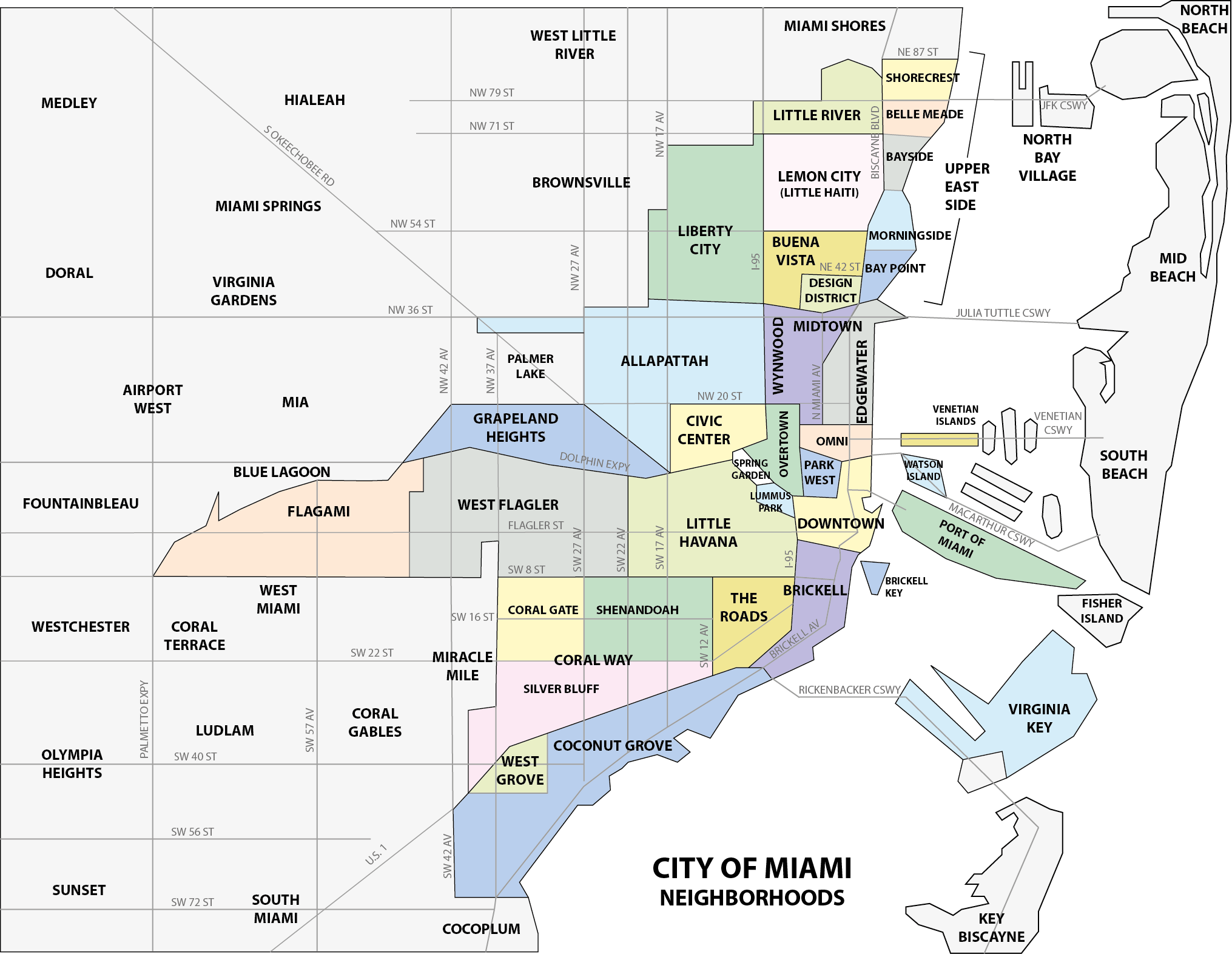
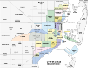
Coordinates: 25°44′55.27″N -80°16′44.81″E / 25.7486861°N 79.7208861°W Country United States State Florida County Miami-Dade County City Miami Subdistricts of Coral Way Neighborhoods list- Bryan Park
- Coral Gate
- Golden Pines
- Parkdale-Lyndale
- Shenandoah
- Silver Bluff
- South Miami
- Vizcaya-Roads
Government - City of Miami Commissioner Frank Carollo and Francis Suárez - Miami-Dade Commissioners Carlos A. Giménez, Bruno Barreiro, and Rebeca Sosa - House of Representatives Carlos Lopez-Cantera (R) and Luis García, Jr. (R) - State Senate Miguel Díaz de la Portilla (R) - U.S. House Ileana Ros-Lehtinen (R) Population (2010) - Total 35,062 - Density 11,645/sq mi (4,496.2/km2) Time zone EST (UTC-05) ZIP Code 33129, 33133, 33135, 33145 Area code(s) 305, 786 Website Coral Way neighborhood Coral Way is a neighborhood within the Miami, Florida that is defined by Coral Way, a road established by Coral Gables founder George E. Merrick during the 1920s. It is located in Miami-Dade County, Florida, United States.
The Coral Way neighborhood is served by the Miami Metrorail at Vizcaya (South Dixie Highway/US 1 and West First Avenue) and Coconut Grove stations (US 1 and West 27th Avenue/SR 9).
Contents
History
The Architecture in the Coral Way neighborhoods reflects the early-20th Century. Some of the oldest sections contain a mixture of Mission Revival Style architecture and Bungalow homes of the 1920’s, along with the Art Deco style from the 1930’s and the modest post-World War II dwellings.
The Coral Way area is best known for its historic urban boulevard along SW 22nd Street (Coral Way). One of the main thoroughfares between Coral Gables and the City of Miami, Coral Way passes through the City of Miami between SW 37th Avenue and Brickell Avenue. The Coral Way Corridor began in 1922 with citrus lined streets; later growing to have streetcar tracks down the center of the road, connecting Downtown Miami to Coral Gables. In 1929, a Roadside Beautification Program was started, and 1200 Banyan trees were planted along the median of the boulevard. Today, Coral Way remains one of the most beautiful corridors in South Florida. [1]
Geography
The sub-neighborhoods within Coral Way include: Shenandoah, Silver Bluff, Vizcaya-Roads, Coral Gate, Parkdale-Lyndale, South Miami, Bryan Park, and Golden Pines.
Shenandoah
Shenandoah is a smaller sub-neighborhood within the larger Coral Way neighborhood. It is located just south of Little Havana, roughly bounded by SW 16th Street (north), Coral Way (south), SW 27nd Avenue (west) and SW 12th Avenue (east). It is located at 25°45′36″N 80°13′19″W / 25.76°N 80.222°W, with an elevation 10 feet (3.0 m).[2]
Silver Bluff
Silver Bluff Estates is a smaller sub-neighborhood within the larger Coral Way neighborhood. It is located just south of Coral Way (SW 22nd Street), west of SW 17th Avenue, east of SW 27th Avenue and north of South Dixie Highway. Much of this territory was the "City of Silver Bluff", which was annexed into the City of Miami in 1926. It is located at 25°44′56″N 80°14′10″W / 25.749°N 80.236°W, with an elevation 10 feet (3.0 m).[3]
Coral Gate
Coral Gate is a smaller sub-neighborhood within the larger Coral Way neighborhood. It is roughly located south of SW 8th Street, east of SW 37th Avenue, north of Coral Way and SW 22nd Avenue. The eastern side of Coral Gate is sometimes also called "Bryan Park".[4] Coral Gate borders Coral Gables and on the southern end, Coral Gables.
Demographics
As of 2000,[5] Coral Way had a population of 55,951 and 69,041[6] residents, with 21,363 households, and 14,105 families residing in the city. The median household income was $37,168.89. The racial makeup of the neighborhood was 81.10% Hispanic or Latino of any race, 0.41% Black or African American, 17.28% White (non-Hispanic), and 1.21% Other races (non-Hispanic).
The zip codes for Coral Way include 33129, 33133, 33135, and 33145. The area covers 6.697 square miles (17.35 km2). As of 2000, there were 32,879 males and 36,162 females. The median age for males were 38.6 years old, while the median age for females were 43.3 years old. The average household size had 2.5 people, while the average family size had 3.1 members. The percentage of married-couple families (among all households) was 42.3%, while the percentage of married-couple families with children (among all households) was 15.7%, and the percentage of single-mother households (among all households) was 7.1%. The percentage of never-married males 15 years old and over was 14.6%, while the percentage of never-married females 15 years old and over was 12.1%.[6]
As of 2000, the percentage of people that speak English not well or not at all made up 35.8% of the population. The percentage of residents born in Florida was 19.4%, the percentage of people born in another U.S. state was 8.1%, and the percentage of native residents but born outside the U.S. was 2.1%, while the percentage of foreign born residents was 70.4%.[6]
Economy
The Consulate-General of Costa Rica in Miami is located in Suite 401 at 2730 SW 3rd Avenue in Coral Way.[7]
Transportation
Coral Way is served by Metrobus throughout the area, and by the Miami Metrorail at:
- Vizcaya (SW 32nd Road and U.S. 1)
- Coconut Grove (SW 27th Avenue and U.S. 1)
- Douglas Road (SW 37th Avenue and U.S. 1)
Education
Miami-Dade County Public Schools operates area public schools:
Public schools
Elementary schools
- Coral Way Elementary School
- Shenandoah Elementary School
- Silver Bluff Elementary School
- Frances S Tucker Elementary School
- Coral Way K-8 School
- Merrick Educational Center
Middle schools
- Shenandoah Middle School
Adult education
- The English Center
Private schools
- José Martí Schools
- Lincoln Martí School
- Brito Miami Private School
Libraries
Miami-Dade Public Library operates area public libraries:
- Shenandoah Library
Parks
- Douglas Park
- Coral Gate Park
- Shenandoah Park
- Cuban Memorial Boulevard Park
- Woodlawn Park Cemetery (cemetery)
References
- ^ City of Miami-Neighborhood Enhancement Teams
- ^ Shenandoah, FL Community Profile
- ^ Silver Bluff Estates, FL Community Profile
- ^ http://www.city-data.com/neighborhood/Bryan-Park-Miami-FL.html
- ^ "Demographics of Coral Way Miami, FL.". miamigov.com. http://www.miamigov.com/Planning/pages/services/Census.asp. Retrieved 2008-06-11.
- ^ a b c "Demographics of Coral Way, Miami, Florida.". city-data. http://www.city-data.com/neighborhood/Coral-Way-Miami-FL.html. Retrieved 2009-08-28.
- ^ "Consulates in the United States." Embassy of Costa Rica in Washington D.C. Retrieved on January 31, 2009.
Neighborhoods of Miami Allapattah · Brickell (Key) · Buena Vista · Civic Center · Coconut Grove · Coral Way · Design District · Downtown · Edgewater · Flagami · Grapeland Heights · Liberty City · Little Haiti · Little Havana · Lummus Park · Midtown · Omni · Overtown · Park West · The Roads · Upper Eastside · Venetian Islands · Virginia Key · Watson Island · West Flagler · Wynwood
Coordinates: 25°44′55.27″N 80°16′44.81″W / 25.7486861°N 80.2791139°W
Categories:- Neighborhoods in Miami, Florida


Wikimedia Foundation. 2010.