- Montecatini Val di Cecina
-
For other uses, see Montecatini (disambiguation).
Montecatini Val di Cecina — Comune — Comune di Montecatini Val di Cecina 

Coat of armsLocation of Montecatini Val di Cecina in Italy
 Montecatini Val di Cecina
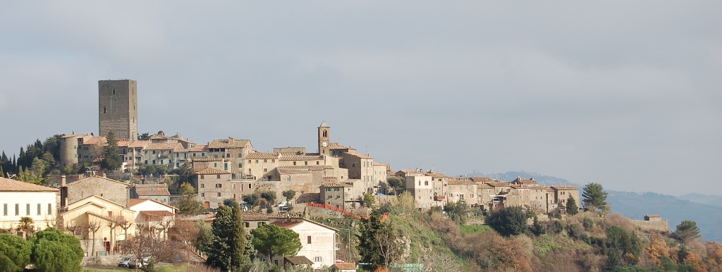
Coordinates: 43°23′37″N 10°45′0″E / 43.39361°N 10.75°ECoordinates: 43°23′37″N 10°45′0″E / 43.39361°N 10.75°E Country Italy Region Tuscany Province Pisa (PI) Frazioni Ponteginori, La Sassa, Querceto, Miemo, Casaglia, Gello Government - Mayor Sandro Cerri (since april 2008) Area - Total 155.19 km2 (59.9 sq mi) Elevation 416 m (1,365 ft) Population (2008) - Total 1,908 - Density 12.3/km2 (31.8/sq mi) Demonym Montecatinesi Time zone CET (UTC+1) - Summer (DST) CEST (UTC+2) Postal code 56040 Dialing code 0588 Patron saint St. Blaise Saint day February 3 Website Official website Montecatini Val di Cecina is a small hilltown and comune in the province of Pisa in Tuscany (central Italy). Located approximatively 60 km south of Pisa, the medieval town sits on the Poggio la Croce hill overlooking the Cecina Valley and the larger hilltown of Volterra, which lies just 15 km away.
Local agriculture and the old copper mine provided Montecatini Val di Cecina with a degree of prosperity in the early Middle Ages. Like many Tuscan hilltop towns, its medieval aspect has been preserved precisely because lack of economic development. Today, Montecatini Val di Cecina is enjoying a small economic revival through tourism though on a modest scale.
History
Montecatini Val di Cecina was first settled by ancient Etruscans, who populated the nearby city of Volterra. Later it served as a Roman look-out post as it overlooks what was a busy Roman road. The castle and tower that dominate the town were built in the Middle Ages by Filippo Belforti, whose family ruled the territory for about a century. By the 11th century, Montecatini Val di Cecina was in the Catholic parish administered from nearby Gabretto. In 1351, the area came under the rule of the Bishop of Volterra. In 1452, it was absorbed into the Republic of Florence (later Grand Duchy of Tuscany), to which it belonged until the unification of Italy in 1861. [1]
Main sights
Inside the village walls, which feature cylindrical towers around the perimeter, medieval buildings are tightly spaced, separated by narrow streets or alleys, and a few small piazzas. The town is dominated by the Belforti tower.
Other buildings include the Palazzo Pretorio, with an elegant porch that runs underneath a cross-ribbed vaulted roof supported by six Ionian columns, and the Chiesa San Biagio, built in the Romanesque - Gothic style during the 14th Century. The church has an asymmetrical shape with a very plain portal facing a side street. The church is divided by a central nave with two side aisles separated by columns.
Nearby there is the frazione (village) of Castel Querceto, with the Romanesque parish church Chiesa San Giovanni.
Also on a hill, and also possessing a fortified tower that offers a commanding view of the country stretching toward Volterra and the Tyrrhenian Sea, is the village of La Sassa. An old copper mine lies between two other very old villages, Casaglia and Gello
External links
Tuscany · Comuni of the Province of Pisa Bientina · Buti · Calci · Calcinaia · Capannoli · Casale Marittimo · Casciana Terme · Cascina · Castelfranco di Sotto · Castellina Marittima · Castelnuovo di Val di Cecina · Chianni · Crespina · Fauglia · Guardistallo · Lajatico · Lari · Lorenzana · Montecatini Val di Cecina · Montescudaio · Monteverdi Marittimo · Montopoli in Val d'Arno · Orciano Pisano · Palaia · Peccioli · Pisa · Pomarance · Ponsacco · Pontedera · Riparbella · San Giuliano Terme · San Miniato · Santa Croce sull'Arno · Santa Luce · Santa Maria a Monte · Terricciola · Vecchiano · Vicopisano · VolterraCategories:- Cities and towns in Tuscany
- Communes of the Province of Pisa
- Hilltowns in Italy
- Hilltowns in Tuscany

Wikimedia Foundation. 2010.