- Presque Isle State Park
Geobox Protected Area
name = Presque Isle State Park
native_name =
other_name =
other_name1 =
category_local = Pennsylvania State Park
category_iucn = III
image_size = 300
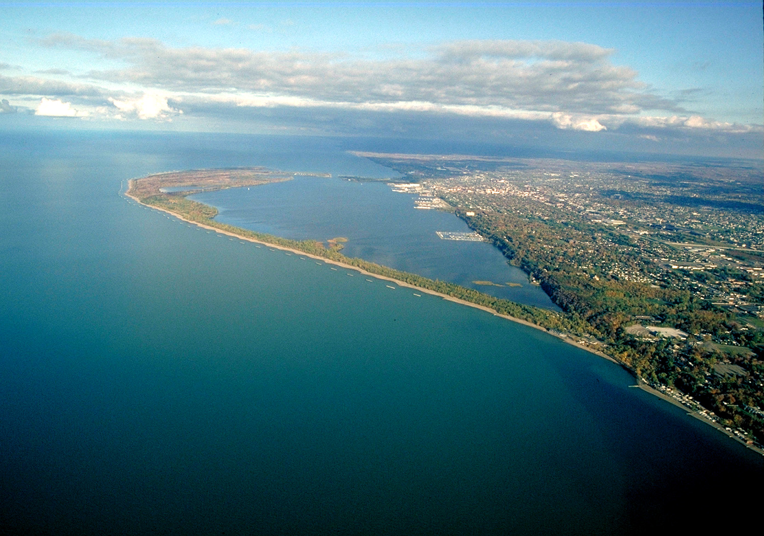
image_caption = Aerial view of Presque Isle toward the east-northeast
etymology = "presqu'île", French for "almost an island"
country = United States
state = Pennsylvania
region_type = County
region = Erie
district_type = Township
district = Millcreek
city =
location =Lake Erie
location_note = cite web| last = Geographic Names Information System | first =United States Geological Survey | date = August 2, 1979 | url =Gnis3|1184396| title = Geographic Names Information System Feature Detail Report: Presque Isle State Park | accessdate =2007-11-16]
lat_d = 42
lat_m = 09
lat_s = 47
lat_NS = N
long_d = 80
long_m = 06
long_s = 03
long_EW = W
elevation_imperial = 581
elevation_round = 1
area_unit = acre
area_imperial = 3200
area_round = 1
area_note = cite web| url=http://www.dcnr.state.pa.us/STATEPARKS/parks/presqueisle.aspx| title = Presque Isle State Park | accessdate=2007-01-30| publisher= Pennsylvania Department of Conservation and Natural Resources]
area1_imperial =
area1_type =
length_imperial =
length_orientation =
width_imperial =
width_orientation =
highest =
highest location =
highest_lat_d =
highest_lat_m =
highest_lat_s =
highest_lat_NS =
highest_long_d =
highest_long_m =
highest_long_s =
highest_long_EW =
highest_elevation_imperial =
lowest =
lowest_location =
lowest_lat_d =
lowest_lat_m =
lowest_lat_s =
lowest_lat_NS =
lowest_long_d =
lowest_long_m =
lowest_long_s =
lowest_long_EW =
lowest_elevation_imperial =
biome =
biome_share =
biome1 =
biome1_share =
geology =
geology1 =
plant =
plant1 =
animal =
animal1 =
established_type =
established = 1921
established_note = cite book |last= Cupper |first= Dan |title= Our Priceless Heritage: Pennsylvania’s State Parks 1893-1993 |year= 1993 |publisher= Commonwealth of Pennsylvania,Pennsylvania Historical and Museum Commission for Department of Natural Resources, Bureau of State Parks |location=Harrisburg, Pennsylvania |isbn= 0-89271-056-X]
management_body = Pennsylvania Department of Conservation and Natural Resources
management_location =
management_lat_d =
management_lat_m =
management_lat_s =
management_lat_NS =
management_long_d =
management_long_m =
management_long_s =
management_long_EW =
management_elevation =
visitation = over 4,000,000 annually
visitation_note =
visitation_year =
free_type = Nearest city
free =Erie, Pennsylvania
free1_type =
free1 =

map_size = 300
map_caption = Presque Isle State Park, Lake Erie, and Erie, Pennsylvania
map1 = Pennsylvania Locator Map.png
map1_locator = Pennsylvania
map1_size =
map_first =
website = [http://www.dcnr.state.pa.us/stateparks/parks/presqueisle.aspx Presque Isle State Park]Presque Isle State Park (pronEng|ˌprɛskˈʔaɪl) is a convert|3200|acre|km2|sing=on Pennsylvania state park on an arching sandy
peninsula that juts intoLake Erie , convert|4|mi|km|0 west of the city of Erie, in Millcreek Township, Erie County,Pennsylvania , in the United States. The peninsula sweeps northeastward, surroundingPresque Isle Bay along the park's southern coast. It has convert|13|mi|km|0 of roads, convert|21|mi|km|0 of recreational trails, 13 beaches for swimming, and a marina. Popular activities at the park includeswimming ,boating ,hiking ,biking , andbird watching .The recorded history of Presque Isle begins with the Erielhonan, a Native American tribe who gave their name to Lake Erie, and includes French, British, and American forts, as well as serving as a base for Commodore
Oliver Hazard Perry 's fleet in theWar of 1812 . With the growing importance of shipping on Lake Erie in the 1800s, Presque Isle became home to severallighthouse s and what became aUnited States Coast Guard station. In 1921 it became a state park, and as of 2007 it hosts over 4 million visitors per year, the most of any Pennsylvania state park.The Presque Isle peninsula formed on a
moraine from the end of theWisconsin Glaciation and is constantly being reshaped by waves and wind. This leads to seven ecological zones within the park, which provide a classic example ofecological succession . ANational Natural Landmark since 1967, the park has been named one of the best places in the US to watch birds, and protects them in its Gull Point State Park Natural Area. The newTom Ridge Environmental Center at the entrance to the park allows visitors to learn more about the park and its ecology. Presque Isle State Park has been chosen by the Pennsylvania Bureau of Parks for its list of "Twenty Must-See Pennsylvania State Parks".History
Early inhabitants
Presque Isle was formed at the end of the Wisconsin Glaciation about 11,000 years ago.cite web| url=http://www.pserie.psu.edu/seagrant/rediscoveries/curriculum/PresqueIsle.pdf| title = Presque Isle - Origin of Presque Isle | accessdate=2007-10-31| publisher=
Pennsylvania State University ] The earliest known inhabitants of the southern Lake Erie coast were the Erielhonan, also known as the "Eriez", an Iroquoian speaking tribe of Native Americans. Erielhonan meant the "Cat" or "Raccoon" people, and the name "Erie", a corruption of Erielhonan, became the name of the lake and county in which Presque Isle Park is found and of the city nearest the park.cite book| last = Smith| first = Marvin T.| title = Archaeology of Aboriginal Cultural Change in the Interior Southeast: Depopulation During the Early Historic Period| publisher = University Press of Florida| year = 1987| location = Gainesville ] cite book |last=Donehoo |first= Dr. George P. |title= A History of the Indian Villages and Place Names in Pennsylvania |origdate= 1928 |url= http://www.srbc.net/docs/IndianNamesDataChart.PDF|format= PDF|accessdate= 2007-11-16|edition= Second Reprint Edition |year= 1999|publisher= Wennawoods Publishing |location=Lewisburg, Pennsylvania |id= ISBN 1-889037-11-7|pages= 290|quote = ISBN refers to a 1999 reprint edition. URL is for the Susquehanna River Basin Commission's web page of Native American Place names, quoting and citing the book.]An Erielhonan legend taught that the
Great Spirit led them to Presque Isle because of the wealth of game, the abundance of cleanfresh water , and the cool breezes "coming from the land of snow and ice", i.e. Canada.cite web| url=http://www.presqueisle.org/history.html| title = Presque Isle - History | accessdate=2007-01-30| publisher=CyberInk, LP] Another legend explains how the Eriez ventured into Lake Erie in search of the land where the sun set.cite web| url=http://www.dcnr.state.pa.us/STATEPARKS/parks/presqueisle_history.aspx| title = Presque Isle State Park - History | accessdate=2007-09-11|publisher=Pennsylvania Department of Conservation and Natural Resources] The spirit of the lake blew a fierce storm to keep the Eriez from finding the sun. To protect the Eriez from the storm, their god laid his outstretched arm into the lake, giving them safety during the storm. The god's arm remained in the lake, protecting the tribe's future generations.The Erielhonan are believed to have lived and farmed on the peninsula. They fought several wars, the last starting in 1653 with the Five Nations of the
Iroquois . After initial victories over the Senecas, in 1654 the Erielhonan lost their largest village, Rique (at the modern city of Erie), destroyed by 1,800 Iroquois warriors. By 1656 the Erielhonan were destroyed as a people, although the Iroquois adopted survivors, absorbed primarily into the Senecas.Forts, settlers, and War of 1812
The French first named the peninsula in the 1720s; "
presque-isle " means "almost an island" in French. They builtFort Presque Isle at the modern city of Erie in the summer of 1753, naming it for the peninsula that protected the fort. The French also built two "military outposts" (probably of brick) on Presque Isle itself, one at the entrance to the peninsula and the other at the eastern point. During theFrench and Indian War , the French abandoned their outposts and burned their fort in 1759. [cite book |last= Bates |first= Samuel P. |title= History of Erie County, Pennsylvania, Volume I |year= 1884 |publisher= Warner, Beer's and Company |location= Chicago |pages= p. 503 ] The British constructed a new fort of the same name that year, which later fell to Native American forces on June 19, 1763, duringPontiac's Rebellion . [cite book |last= Dowd |first= Gregory Evans |title= War under Heaven: Pontiac, the Indian Nations, & the British Empire |year= 2002 |publisher= Johns Hopkins University Press|location= Baltimore |isbn= 0-8018-7079-8 |pages= p. 128 ]Presque Isle passed from British to American control after the
American Revolutionary War , and the Iroquois sold their rights to the land containing the peninsula to the United States at the second Treaty of Fort Stanwix in 1784. Pennsylvania did not acquire an undisputed title to the land until it purchased theErie Triangle from the Federal government on April 3, 1792. In 1795 GeneralAnthony Wayne built a new, American "Fort Presque Isle", and on April 18 of that year the town of "Presqu' Ile", since renamed Erie, was laid out near it. Wayne died at the fort on December 15, 1796, and was originally buried there. [cite book |last= Albert |first= George Dallas |title= Report of the Commission to Locate the Site of the Frontier Forts of Pennsylvania. Volume Two: The Frontier Forts of Western Pennsylvania |year= 1896 |publisher= Clarence M. Busch, State Printer of Pennsylvania |location=Harrisburg, Pennsylvania |pages= pp. 537-566 |url= http://www.rootsweb.com/~usgenweb/pa/1pa/1picts/frontierforts/ff37.html |accessdate= 2007-11-16 ]Erie County was formed from Allegheny County on March 12, 1800. Millcreek Township, which initially contained both the Presque Isle peninsula and village of Erie, was one of the original townships. Erie was named the
county seat in 1803, incorporated as a borough in 1805, and became a city in 1851.cite book |last= Godcharles |first= Frederic A. |authorlink = Frederic A. Godcharles |title= Pennsylvania: Political, Governmental, Military and Civil: Political and Civil History Volume |edition= First edition |year= 1933 |publisher= The American Historical Society |location= New York, New York ]During the
War of 1812 , Presque Isle played a part in the victory over the British in theBattle of Lake Erie .citeweb|publisher=Flagship Niagara League|url=http://www.brigniagara.org/battle.htm|title = Niagara History–Battle of Lake Erie |accessdate=2007-05-30] Oliver Hazard Perry, commander of the American fleet, made strategic use of the bay to build a pier and a place to construct six of the nine ships in his fleet; some of the timber used probably came from Presque Isle. Using this location protected the men by creating an obstacle, forcing potential attackers to circumnavigate the peninsula to reach them.The "Little Bay" near the tip of the peninsula where the ships sheltered, next to the current Perry's Monument, was later named "Misery Bay" because of the hardships during the winter of 1813–1814, after the men returned there from battle. Many men suffered from
smallpox and were kept inquarantine near the bay. A great many infected men died and were buried in what is now called Graveyard Pond.After the Battle of Lake Erie on September 10, 1813, Perry's two largest ships were badly damaged, and the US Brig "Lawrence" was intentionally sunk in Misery Bay. The "Lawrence" was raised in 1875 but was burned while on display at the 1876
Centennial Exposition . The US Brig "Niagara" was initially repaired, then sunk for preservation in 1820 and raised in 1913, and parts of it were eventually used in the modern "Niagara", based across Presque Isle Bay in Erie.Lighthouses and Coast Guard
The Presque Isle peninsula forms Presque Isle Bay, which serves as a natural harbor for Erie. During the 19th century, as Lake Erie navigation grew more important, shipping aids were built on Presque Isle. As of 2007, two main
lighthouses can be found in the park. TheErie Harbor North Pier Light began as a wooden tower, erected in 1830. In 1858, a stronger steel structure was brought from France and installed at Erie to replace the wooden beacon, which had been damaged by a schooner. This light still stands at the far eastern side of the park, near the inlet between the lake and the bay.The
Presque Isle Light was constructed in 1872 on the north side of Presque Isle and was lit on July 12, 1873. This light is convert|74|ft|m|0 tall, with a red brick house that is used as a park residence. Today the lighthouse is maintained by the United States Coast Guard and flashes a white light to warn ships of the sandy peninsula that juts into Lake Erie. A third, smaller lighthouse was built in 1906 by theErie Waterworks on the Presque Isle Bay side of the peninsula. Today it stands in the ferry landing for the Eriewater taxi service, south of the former waterworks along the state park's multi-purpose trail on the southeast side of Presque Isle. [cite web|url= http://www.lighthousefriends.com/light.asp?ID=290 |title = Presque Isle Lighthouse, Pennsylvania |publisher = Lighthousefriends.com |accessdate = 2007-11-17] [cite web|publisher=The Port of Erie | url=http://www.porterie.org/transit_map_lg.gif|title= Bayfront Transportation Systems | accessdate=2007-11-17]United States Life-Saving Service District 9 opened a life-saving station (LSS) at Presque Isle in 1876. William Clark was the keeper from 1877 until he drowned in 1891. He was succeeded by Andrew Jansen, who was the keeper until 1914. When the Life-Saving Service and theRevenue Cutter Service merged in 1915 to become theUnited States Coast Guard , LSS Presque Isle, also called the Erie life-saving station, became Coast Guard Station #236. The station, still in operation, is assigned to the Ninth District of the United States Coast Guard. cite web | url = http://www.uscg.mil/d9/ | title = Ninth Coast Guard District | accessdate = 2007-11-01 | publisher =United States Department of Homeland Security ]Modern era and state park
In 1908, Erie started building a
waterworks on Presque Isle to providefresh water for the city. Water from Lake Erie was pumped into two basins on the peninsula, where particulates in the water were allowed to settle, removing them from the lake water. After treatment, the water flowed into the waterlines of the city. In 1917 a pumphouse powered by a steam boiler and engine was built: this pumped the water from one basin into the other, then across Presque Isle Bay to Erie. This system of supplying drinking water for Erie operated until 1949. The pumphouse is now used forzebra mussel control and as a concession stand for bicycle and surrey rentals within the state park.As Pennsylvania's only surf beach, the Presque Isle beaches were already a popular attraction when the state legislature authorized the creation of the "Pennsylvania State Park at Erie" in May 1921. Oversight was given to the new "State Park and Harbor Commission of Erie", including local representation, instead of to the state Department of Forests and Waters. Presque Isle quickly became the most popular state park in Pennsylvania. Presque Isle was an early example of locating state parks near cities, a trend that would become prevalent statewide only in the 1960s.
The first paved road was built in the park in 1924, and today 13 miles (21 km) of roads run through the park.
Pennsylvania Route 832 , which is the main road to the park, is also known as Peninsula Drive. [cite map|publisher=Pennsylvania Department of Transportation | title = General Highway Map, Erie County, Pennsylvania |year=2007 |scale=1 : 65,000 |url=ftp://ftp.dot.state.pa.us/public/pdf/BPR_pdf_files/Maps/GHS/Roadnames/erie_GHSN.PDF |accessdate= 2007-07-27 "Note: shows Presque Isle State Park "] Presque Isle has been referred to as "Peninsula State Park". [cite book|title=Pennsylvania: A Guide To The Keystone State|author=Writers' Program of the Work Progress Administration in the State of Pennsylvania|authorlink= Federal Writers' Project|coauthors=Pennsylvania State Department of Public Instruction|url=http://collection1.libraries.psu.edu/cgi-bin/showfile.exe?CISOROOT=/digitalbks2&CISOPTR=18341|year=1940|month=December |publisher=Oxford UP|location=New York, NY |accessdate=2007-11-24|series=American Guide Series|page=xxviii] The Perry Monument in the park was constructed in 1926 near Misery Bay and the burials in Graveyard Pond.By 1937 official state publications were referring to the park as "Presque Isle State Park", [cite news |title= Pennsylvania has everything! |url= http://www.libraries.psu.edu/do/digitalbookshelf/28559645/28559645_part_1.pdf |format= PDF |work= Brochure |publisher= Pennsylvania State Publicity Commission |year= 1937 |accessdate=2007-11-11 ] and that same year it led the state park system with 1.4 million visitors. In the 1950s the peninsula was enlarged to accommodate new roads and parking, using 3 million cubic yards (2,294,000 m³) of sand dredged from the interior of the peninsula. The resulting basin became the current marina. Other new facilities included three modern bath houses built in 1957. That same year Gull Point (at the eastern end of the peninsula) was named a nature preserve by the state.cite news|last=Guerriero|first=John|title=Presque Isle: Toward an Uncertain Future |date=
2007-05-26 |publisher=Erie Times-News |url= http://www.goerie.com/apps/pbcs.dll/article?AID=/20070526/TOURISM01/705260384/-1/TOURISM |accessdate=2007-11-19] cite web | url = http://www.presqueisle.org/gull_point.html | title = Gull Point: A fragile ecosystem | accessdate = 2007-11-15 | publisher = CyberInk, LP]In November 1967, Presque Isle was named a
National Natural Landmark by theNational Park Service . [cite web|url =http://www.nature.nps.gov/nnl/registry/usa_map/states/pennsylvania/NNL/PI/index.cfm |title= Presque Isle: National Natural Landmark |publisher =National Park Service | accessdate = 2007-11-13] A recommendation was made to abolish the independent board as early as 1930, although this did not come about until January 19, 1971, with the creation of the state Department of Environmental Resources (which later became the DCNR).cite book| title = History of Pennsylvania's State Parks | last = Forrey |first = William C. | year = 1984 |publisher = Bureau of State Parks, Office of Reseources Management, Department of Environmental Resources, Commonwealth of Pennsylvania |location = Harrisburg, Pennsylvania (No ISBN) ] From 1989 to 1992, over 50 breakwaters were built along the western and northern shore of the peninsula to help control erosion. As part of the "State Parks 2000" of thePennsylvania Department of Conservation and Natural Resources (DCNR) strategic plan, Gull Point was named a "State Park Natural Area for rare and migratory shorebirds to rest, feed and possibly nest". cite web| url=http://www.dcnr.state.pa.us/stateparks/natural/naturalareas.aspx| title = Natural Areas | accessdate=2007-11-19| publisher=Pennsylvania Department of Conservation and Natural Resources ]The
Tom Ridge Environmental Center at the entrance to the park opened in May 2006. As of 2007, the Pennsylvania DCNR Bureau of Parks, which administers all 120 Pennsylvania state parks, had chosen Presque Isle for its "Twenty Must-See Pennsylvania State Parks" list, citing its status as Pennsylvania's only surf beach, its status as a National Natural Landmark, and its "geological and biological diversity and its historic significance". [cite web| url = http://www.dcnr.state.pa.us/stateparks/twenty/20parks.aspx | title = Twenty Must-See Pennsylvania State Parks | accessdate = 2007-08-08| publisher = Pennsylvania Department of Conservation and Natural Resources "Note: Despite the title, 21 parks are on the list; Colton Point andLeonard Harrison State Park s are treated as one."] It was included as one of 16 featured in the first ever official Pennsylvania state parks calendar (for 2008). [cite web| url = http://www.dcnr.state.pa.us/stateparks/calendar.aspx | title = 2008 Pennsylvania State Parks Calendar | accessdate = 2007-11-11| publisher = PA DCNR]Geology
Presque Isle is a recurved sand spit that was formed during the Wisconsin glacial period, which ended around 10,000 BC and was the last major continental glaciation. The ice sheet advanced into the basin now occupied by
Lake Erie , stopped for a while, and retreated to the north, leaving behind amoraine . Thismoraine marks the terminus of the episode of ice advance, consists of clay, sand, and gravel, and eventually became the Presque Isle peninsula. The deposits are constantly being re-worked by wave action and are gradually migrating to the northeast due tolongshore drift .cite web|url=http://www.dcnr.state.pa.us/topogeo/parkguides/Pg21.pdf |title = Pennsylvania Trail of Geology - Presque Isle State Park, Erie County: A Dynamic Interface of Water and Land |format = PDF |accessdate = 2007-12-11 |author = John G. Kuchinski |publisher = Pennsylvania Bureau of Topographic and Geologic Survey, Pennsylvania Bureau of State Parks |year=1991]As noted, the name "presque-isle" literally means "almost an island" in French. In fact, Presque Isle has been an island rather than a peninsula for brief periods. It has been cut off from the mainland four times since 1819, the longest stretch being the 32 years from 1832 to 1864, and each time the U.S. Army Corps of Engineers has reconnected it.cite web| url=http://www.dcnr.state.pa.us/STATEPARKS/parks/presqueisle_wildlife.aspx| title = Presque Isle State Park - Wildlife | accessdate=2007-09-11| publisher=Pennsylvania Department of Conservation and Natural Resources]
The peninsula was breached five times between 1917 and 1922, the year after Presque Isle became a state park. While repair efforts then included plugging the breach with bales of hay and wood, in the 1950s a state and federal program built a concrete
seawall . Fifty-eight breakwaters, built by 1992 to slowerosion , have "captured" the sand and significantly slowed its movement eastward. Even with the breakwaters, new sand has to be brought in annually to replenish the beaches. [cite news|last=Guerriero|first=John|title=Beaches replenished|date=2007-09-21 |publisher=Erie Times-News |url=http://www.goerie.com/apps/pbcs.dll/article?AID=2007709210373|accessdate=2007-10-15]Presque Isle protects the natural Presque Isle Bay, which creates a deep and wide harbor for the city of Erie. The bay is often filled with
pleasure craft as well as cargo ships from all over the world that use theGreat Lakes shipping port. Erie became an international port after the opening of theSaint Lawrence Seaway in 1959.Flora, fauna, and habitat
Ecological zones and succession
According to the DCNR, because it has so "many unique habitats, Presque Isle contains a greater number of the state's endangered, threatened and rare species than any other area of comparable size in Pennsylvania." The DCNR recognizes seven different ecological zones within Presque Isle State Park, each with a different plant and animal community. These zones are: Lake Erie; the bay and shoreline; sandy plain and new ponds; sand dunes and ridges;
marsh es and old ponds; thicket and sub-climax forest; and climax forest. Lake Erie, which surrounds the park, is the first zone and is home to 80 species of fish and at least six species of crustaceans.cite web | url = http://www.presqueisle.org/nature_of_pi.html | title = Nature of Presque Isle | accessdate = 2007-11-15 | publisher = CyberInk, LP] cite web | url = http://www.innvista.com/science/ecology/parks/presque.htm | title = Presque Isle State Park | accessdate = 2007-11-17 | publisher = Inn Vista "Note": the information on flora and fauna here is provided by "David Rutkowski, Assistant Park Manager, Presque Isle State Park".]The remaining ecological zones, with their progression from shoreline to climax forest, are a classic illustration of the concept of
ecological succession . Much of this progression is due to the changing nature of Presque Isle and its shifting shoreline and dunes. The shoreline, the second zone, is formed by wave action and is in equilibrium between erosion and deposition, with the initial plants stabilizing the sand of the new shoreline. The newly formed sandy plain and the ponds formed in it are the third zone. The ponds start as trapped pockets of lake water and can erode away or be filled by wind-blown sand or drifting dunes. The new ponds provide habitat for plants and animals: for example, the state park is home to 89 species ofOdonata (dragonflies and damselflies) andLepidoptera , including 35 different butterflies, as well as 84 different sorts of spiders.Sand dunes and ridges are the fourth zone, formed when beach sand transported by wind and waves becomes trapped by vegetation. Dunes grow and are stabilized by grasses, followed by other types of vegetation. This provides habitat for amphibians, birds, mammals, and reptiles. Old dunes can become more permanent ridges, which shelter ponds. These dunes, ridges, and ponds are often remnants of previous shorelines; at the Presque Isle State Park "Long Pond" just east of the marina, dunes and ridges mark the eastern shoreline from 1862. The fifth ecological zone consists of old ponds and marshes. Ponds protected by dunes and ridges are more stable; these old ponds support more plant and animal life, and as they fill with vegetation, they become marshes. Old ponds and marshes have high
biodiversity . Nearly 400 species of terrestrial vertebrates live on Presque Isle, including 318 different birds, 48 kinds of mammals, 13 types of amphibians, and 19 reptile species.The sixth and seventh ecological zones are characterized by their shrubs and trees, and Presque Isle State Park is home to 633 plant species (195
Monocotyledon s, 410Dicotyledon s, 5Gymnosperm s, 5Horsetail s, 13Fern s, and 5Moss es). The sixth zone, thicket and sub-climax forest, forms when shrubs grow on dying marshes, followed by small trees. The trees shade and thin out the thickets of shrubs, leading to a sub-climax forest. The seventh and final stage is climax forest, where many large trees form a canopy. If left undisturbed, this ecological succession is believed to take 600 or more years, although visitors to parts of Presque Isle State Park can walk through all of these zones in 5 miles (3 km).The Pennsylvania
Audubon Society has listed the park as PennsylvaniaImportant Bird Area (IBA) #1, and it has been rated by "Birder's World" magazine as one the best places in the United States for birdwatching. [cite web|url = http://pa.audubon.org/Sites/Site1.pdf | title = Pennsylvania Important Bird Areas: Site Name Presque Isle State Park |publisher = Pennsylvania Audubon Society | format = PDF |accessdate = 2008-05-03] The diversity of habitats on the peninsula makes it an ideal home for over 320 species of birds. (For comparison, the United States has about 925 bird species.) Forty-five of the bird species found in the park are listed as "endangered " or "threatened", including thepiping plover ,cerulean warbler ,rusty blackbird andsaltmarsh sharp-tailed sparrow .Waterfowl and wading birds live at Presque Isle year round. Four species ofgull and three species oftern can be seen at Gull Point during the summer months. The majority of collection during the annualChristmas Bird Count , which has been held in Erie County since 1956, is garnered from observations made by volunteers within the park. [Christmas Bird Count to Begin At Presque Isle, by David Bruce, Erie Times-News, December 14, 2007] Many differentspecies of plants and animals can also be found at Presque Isle State Park due to the wide variety of ecological zones.Gull Point Natural Area
Human beings have played a role in the ecology of Presque Isle since at least the Erielhonan. The natural drift of sand is hindered or stopped by breakwaters, permanent structures, and roads. Roads also do not absorb rainwater, causing erosion, and break up natural habitats. Excavations such as those to make the waterworks basins or the marina have destroyed habitats, but yearly artificial replenishment with sand helps to create new ones. One area within the park is closed to all public use from April to November to minimize the impact of humans: it is the easternmost part of the park, Gull Point.
Gull Point at Presque Isle State Park has been set aside as a Pennsylvania "State Park Natural Area". These areas provide locations for scientific observation of natural systems; they protect examples of natural interest and beauty as well as examples of unique and typical animal and plant habitats.
Gull Point covers convert|319|acre|km2, of which convert|67|acre|km2 form the Natural Area and are closed to park visitors during the height of the bird migrations. The natural area is a safe haven and resting spot for migrating and nesting birds. Many of the species of birds that rest at Gull Point are not seen anywhere else in Pennsylvania. Presque Isle lies on the
Atlantic Flyway , a major migratory path, and some of these birds migrate from as far north as theArctic Circle to South America. They pass through in November on their long flights south and return in April on their flights north.Erosion and deposition of sand, which has formed Gull Point, continues to change it. From May 1991 to October 2006, Gull Point lost a total of convert|4.6|acre|m2, and if this trend continues, it may become an island. After the breakwaters were constructed in 1992, less sand was added to replenish the beaches. Federal funding of sand replenishment has been cut off since 2005, leading to further reduction in sand added to the peninsula. Without new sand, erosion has reduced the northern beaches of Gull Point, even while regions to the east and south have continued to grow at a slower rate, for a net yearly loss of convert|0.4|acre|m2|sigfig=1.
Tom Ridge Environmental Center
The Tom Ridge Environmental Center (TREC) is the gateway to and administrative center for Presque Isle State Park, as well as housing interactive educational exhibits, a "Discovery Center", classrooms, and research laboratories. The Center, which officially opened on May 26, 2006, is on convert|12|acre|m2 just off Route 832 on a bluff overlooking Lake Erie. TREC is named for former Pennsylvania Governor
Tom Ridge , "who grew up in Erie, worked at the park as a young man and provided funding for the center and numerous Presque Isle projects during his administration."cite web|publisher=Pennsylvania Department of Conservation and Natural Resources|title = Tom Ridge Environmental Center now open at Presque Isle in Erie |url=http://www.dcnr.state.pa.us/news/resource/res2006/06-0607-trecpi.aspx|accessdate=2007-09-18] cite web|publisher=Pennsylvania Department of Conservation and Natural Resources | title = Tom Ridge Environmental Center: Gateway to Presque Isle | url=http://www.dcnr.state.pa.us/stateparks/parks/tomridgecenter.aspx|accessdate=2007-11-19]Construction on the center began in 2002, although the idea for such a center at Presque Isle was some 50 years old. The Presque Isle State Park headquarters began operating from TREC in 2005, and it is also home to offices for the
Pennsylvania Department of Environmental Protection 's Great Lakes and Coastal Zone Management programs, the DCNR Recreation and Conservation program, as well as Presque Isle Audubon, Lake-Erie Allegheny Earth Force, Pennsylvania Sea Grant, Presque Isle Partnership, and thePurple Martin Conservation Association. The Regional Science Consortium, "a collaborative, non-profit organization that focuses on and coordinates educational and research projects for Lake Erie and the upper Ohio River Basin", was organized in 2002 and is based at TREC.cite web|publisher=Regional Science Consortium | title = Regional Science Consortium at the Tom Ridge Environmental Center at Presque Isle | url=http://www.regsciconsort.com/|accessdate=2007-11-20] Its 32 member organizations include schools, school districts, colleges, universities, museums, state agencies, conservation groups, and private corporations from Pennsylvania,Ohio , andOntario .Facilities at the 65,000 square foot (6,039 m²) Tom Ridge Environmental Center include eight research laboratories (including several large aquariums) for the RSC, several classrooms, a "Discovery Center" for younger students to explore science hands-on, interpretive exhibits highlighting local and regional
flora andfauna , as well as the human history and culture of the area. The center also offers alarge-format movie theater, a smaller theater, gift shop, cafeteria, and a 75 foot (23 m) tall observation tower that overlooks Lake Erie. The center was constructed as a "green" building and has received aLeadership in Energy and Environmental Design (LEED) rating from theUnited States Green Building Council . Besides supporting environmental research and education, the center is meant to "increase off-season use" of the state park. cite web |publisher=Tom Ridge Environmental Center, Pennsylvania Department of Conservation and Natural Resources |title = Tom Ridge Environmental Center at Presque Isle |url=http://www.trecpi.org/ |accessdate=2007-11-19]Recreation
In addition to the facilities at TREC, Presque Isle State Park provides opportunities for daytime recreational activity along the Lake Erie and Presque Isle Bay coastlines, as well as on its inland trails and lagoons. Boating, canoeing, fishing, and water skiing are common summer sports, while hiking, biking, inline skating, and bird watching are some of the inland activities. Ice fishing, ice boating, ice skating, and cross-country skiing occupy winter visitors. No admission fee is charged for the park or TREC. cite web | url = http://www.dcnr.state.pa.us/STATEPARKS/parks/presqueisle.aspx#recreation | title = Presque Isle State Park - Recreational Opportunities | accessdate = 2007-11-01 | publisher = Pennsylvania Department of Conservation and Natural Resources ]
Boats of nearly any variety are permitted on Lake Erie at Presque Isle State Park. Boats with
internal combustion engine s are prohibited in the interiorlagoon s, except for Grave Yard Pond, where a concession rents motor and pontoon boats, canoes, and kayaks for recreational use. The park also has a 500-slipmarina , open to boats up to 42 feet (13 m) long, and five boat launches.cite web | author=Pennsylvania Fish and Boat Commission (PFBC) | url= http://www.fish.state.pa.us/water/county/pfbcmaps/erie.htm | title= 2007 PFBC County Maps - Erie County | accessdate= 2007-11-21] Boat tours provide views of the park, lake, bay, and Erie skyline. All boats must have a current registration from any state. Water conditions on Lake Erie can change with little notice, and boaters are asked to use caution.Water skiing andscuba diving are permitted at Presque Isle State Park in designated waters of Lake Erie. Water skiing must take place in Presque Isle Bay or out on Lake Erie and is prohibited within convert|500|ft|m|0 of the shore. Scuba divers must be certified and are required to register at the park office to obtain information on the waters that are open to diving.Presque Isle State Park has two distinct
fishing zones. Lake Erie is home toperch ,trout ,walleye , bass, andsteelhead . Presque Isle Bay is the home ofmuskellunge ,northern pike ,crappie ,smelt , as well as other fish that swim in from the lake. Trout fishing is also allowed in the two waterworks basins, which are stocked by thePennsylvania Fish and Boat Commission . Hunting is prohibited at Presque Isle State Park with the exception of controlledduck andgoose hunting seasons in designated blinds.Presque Isle State Park, which has 13 beaches, is home to the only surf swimming in Pennsylvania. Each beach opens
Memorial Day weekend and closesLabor Day weekend.Lifeguard s are on duty from 10 a.m. until 7:30 p.m. Extensivepicnic facilities are available at most of the swimming areas.Nearby state parks
The following state parks are within convert|30|mi|km|0 of Presque Isle State Park:cite web
last = Michels
first = Chris
year = 1997
url = http://www2.nau.edu/~cvm/latlongdist.html
title = Latitude/Longitude Distance Calculation
publisher =Northern Arizona University
accessdate = 2008-04-23]
*Erie Bluffs State Park (Erie County)References
External links
* [http://www.dcnr.state.pa.us/stateparks/parks/presqueisle.aspx Presque Isle State Park]
* [http://www.presqueisle.org Presque Isle State Park Information]
*
Wikimedia Foundation. 2010.