Messenian Gulf

Messenian Gulf
Messenian Gulf
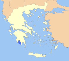
Location of Messenian Gulf
Location Southeast Europe
Coordinates 36°50'N 22°4'E
Ocean type Gulf
Primary sources Mediterranean Sea
Basin countries Greece
Max length 72 km (45 mi)
Max width 42 km (26 mi) (min)
Max depth 2,310 m (7,580 ft)

The Messenian Gulf (Greek: Μεσσηνιακός Κόλπος, Messiniakós Kólpos) is a sea that is part of the Ionian Sea. The gulf is circumscribed by the southern coasts of Messenia and the southwestern coast of the Mani peninsula in Laconia. Its bounds are Venetiko Island to the west and Cape Tainaron to the southeast. The western shores are mostly low-lying, fertile and well-developed, while the eastern shore is dominated by the southern foothills of the Taygetos and comparatively rocky and inaccessible, with few settlements.

The Pamisos River river flows into the gulf near the port town of Kalamata, which is the gulf's major urban centre.

Places by the gulf

  • Koroni - west
  • Longa - west
  • Petalidi - northwest
  • Messini - northwest
  • Kalamata - northeast
  • Kardamyli - east
  • Selinitsa - east
  • Trochylo - southeast
  • Areopoli - southeast
  • Gerolimenas - southeast

References

Coordinates: 36°45′N 22°10′E / 36.75°N 22.167°E / 36.75; 22.167


Wikimedia Foundation. 2010.

Игры ⚽ Нужна курсовая?

Look at other dictionaries:

  • Messenia, Gulf of — Gulf of the Ionian Sea, on the coast of the southwestern Peloponnese, Greece. On the west side of the gulf is the port of Koróni, originally settled by Argives after the First Messenian War (с 735–715 BC) and reoccupied during the Middle Ages by… …   Universalium

  • Mani Peninsula — View from mani The Mani Peninsula (Μάνη in Greek), also long known as Maina or Maïna, is a geographical and cultural region in Greece. Mani is the central peninsula of the three which extend southwards from the Peloponnese in southern Greece. To… …   Wikipedia

  • Kalamata — Infobox Greek Dimos name = Kalamata name local = Καλαμάτα caption skyline = Kalamata city city lat deg = 37 lat min = 2 lon deg = 22 lon min = 7 elevation min = 0 elevation max = 21 periph = Peloponnese prefec = Messenia districts = mayor = party …   Wikipedia

  • Greek National Road 82 — (Pylos Kalamata Sparta) is a west to east highway linking Pylos with the GR 9/E55, Kalamata and downtown Sparta with GR 37/E???. The highway begins in downtown Pylos and runs through the southwestern part of Messenia and through curvy roads and… …   Wikipedia

  • Nedonas — (Νέδωνας) Origin Messinia near the Laconia prefecture Mouth Kalamata (sea level) Length approx. 35 to 40 km Basin area Messenian Gulf, Ionian Sea The Nedonas (Greek: Νέδωνας, older and ancient form …   Wikipedia

  • Golfo de Mesenia — (Μεσσηνιακός Κόλπος) Vista de Kalamata, el principal puerto del golfo …   Wikipedia Español

  • Mantineies — (Μαντίνειες) refer to a geographic area in Outer (Exo) Mani (Messenian) in which are two villages: Megali Mantineia, Avia and Akrogiali, part of the municipality of Avia Mikri Mantineia and Palaio Chorio, part of the municipality/city of Kalamata …   Wikipedia

  • Ionian Sea — The Ionian Sea is an arm of the Mediterranean Sea, south of the Adriatic Sea. It is bounded by southern Italy, including Calabria, Sicily and the Salento peninsula, to the west, by southwestern Albania, including Saranda and Himara, and a large… …   Wikipedia

  • List of rivers of Greece — Tributaries= *Aegean Sea **Thermaic Gulf ***Elpeus ***Aliákmon ***Axios **Evros **Nestos **Pineios (Thessaly) **Spercheios **Krausidonas **Strymonas **Titaresios ***Kifisos (Athens and Piraeus) ***Kifisos (Eleusis) *Tanos River *Ionian Sea… …   Wikipedia

  • Koutala, Messinia — Koutala (Greek: Κουταλά), is a settlement in Greece located near Kalamata. Its 2001 population was 18 for the settlement.Nearest places*Profitis Ilias, north *Artemissia, northeast *Asprochoma, west *Thouria, westPopulationGeographyKoutala is… …   Wikipedia

Share the article and excerpts

Direct link
Do a right-click on the link above
and select “Copy Link”