- Nopah Range
-
Nopah Range Mountain Range 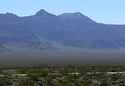 Nopah Range as seem from the Chicago Valley
Country United States State California District Inyo County Coordinates 36°0′21.873″N 116°4′49.084″W / 36.00607583°N 116.08030111°W Highest point - elevation 1,941 m (6,368 ft) Timezone Pacific (UTC-8) - summer (DST) PDT (UTC-7) Topo map USGS Nopah Peak 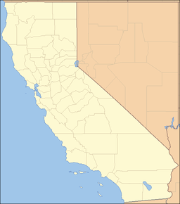
 location of Nopah Range in California [1]
The Nopah Range is located in Inyo County, California, USA, near the eastern border with Nevada.
Geography
The mountain range lies east of the adjacent Resting Spring Range, the Owlshead Mountains and lower Death Valley, and are north of the Kingston Range. The Amargosa River is to the west. They are located directly east of Shoshone, California, and the Chicago Valley, northeast of Tecopa, California, southwest of Pahrump, Nevada, and west of Las Vegas, Nevada.
The Nopah Range mountains reach an elevation of 6,395 feet above sea level at Nopah Peak, in the center of the range. The Nopah Range is approximately 26 miles long.
 Nopah Range, near California State Route 127
See also
- Category: Mountain ranges of the Mojave Desert
References
- Allan, Stuart (2005). California Road and Recreation Atlas. Benchmark Maps. pp. 89 & 97. ISBN 0-929591-80-1.
Categories:- Mountain ranges of Inyo County, California
- Mountain ranges of the Mojave Desert
- California geography stubs


Wikimedia Foundation. 2010.