- Sam Houston Ship Channel Bridge
-
Sam Houston Tollway Ship Channel Bridge 
Carries 
 Beltway 8
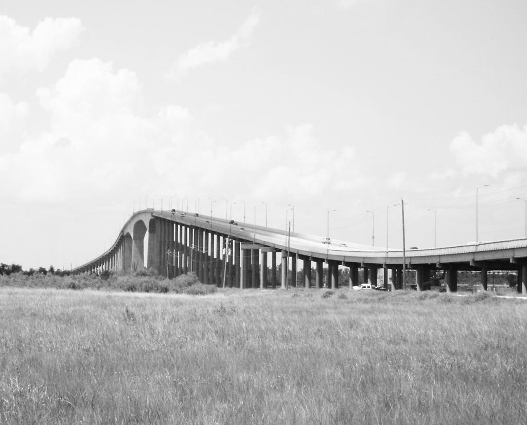
Crosses Houston Ship Channel Locale Harris County, Texas Maintained by Texas Turnpike Authority[1] Design cantilevered concrete trapezoidal haunched hollow box girder bridge[1][2] Material concrete Total length 1,560 feet (480 m) (main bridge)
2 miles (3.2 km) (total length)[1]Width 59 feet (18 m)[1] Longest span 750 feet (230 m)[2] Clearance below 175 feet (53 m)[2] Construction begin 1980[1] Construction end 1982[1] Opened 1982-05-06[2] Coordinates 29°44′09″N 95°08′46″W / 29.73597°N 95.146227°WCoordinates: 29°44′09″N 95°08′46″W / 29.73597°N 95.146227°W 
 Map of bridge location in Texas
Sam Houston Tollway Ship Channel Bridge (otherwise known as the Jesse H. Jones Memorial Bridge) is a bridge in Harris County, Texas. It was acquired from the-then Texas Turnpike Authority (TTA) (now North Texas Tollway Authority) on May 5, 1994 and is now a part of the Harris County Toll Road Authority system. The bridge opened to traffic in May 1982. It carries four lanes of Beltway 8 over the Houston Ship Channel with a clearance of 175 feet (53 m).
Contents
Conception
The 1952 City of Houston planning document recommended a second loop designated the Outer Belt. Harris County took control of the project in 1960. Efforts to construct the Beltway 8 crossing started in the mid-1960s, culminating in an effort vetoed by Governor John Connally on 1967-06-18. Voters twice rejected bond funds for the bridge, so the effort was reconstituted as a toll bridge. This did not work at that time.
In 1978, the Texas Turnpike Authority performed a study showing the project as feasible, and sold $102M (approximately $333.1M in 2008[3]) of bonds to fund it.
Among designs looked at, a cable-stayed design was studied, but not sufficiently understood at the time. Such was later used on the Fred Hartman Bridge, but in 1978 when this bridge was designed, the only US example of a cable-stayed bridge was the Ed Hendler Bridge, meaning there was a deficiency of design and construction experience for the bridge type.
Construction and financing
Construction completed in 1982 and the bridge was opened on 1982-05-06. At the time of completion, the bridge was the longest box girder span in the Western Hemisphere, which record it held until 1997 and the opening of the Confederation Bridge. It is no longer in the top 20 of longest box girder spans.[4]
Traffic volume had been projected to be 4M in 1982, but came in at only 1.69M, a 58% shortfall. This was attributed to a lack of connections to the bridge. Additional ramps were completed in 1984, but the results were insufficient to service the bonds. The bonds were refinanced in 1985 at a rate of 12.625% (original rate was 7.54%), and could not be paid off until 2002-07-01. Total debt service as of the end of 1985 was $522M, with a minimum of $176M.[5]
Traffic volume increased, but not sufficiently to cover the 1985 junk bonds. In 1994, Harris County took over the bridge for the consideration of TxDOT contributing money toward further area highway construction. By 2002, the average toll of $2 toll brought in approximately $20M, enough to cover bond payments.[5]
See also
References
- ^ a b c d e f Jesse H. Jones Memorial Bridge at Structurae
- ^ a b c d Slotboom, Eric (2003). Houston Freeways: A Historical and Visual Journey. O. F. Slotboom. ISBN 978-0974160535., p. 366
- ^ [|Friedman, S. Morgan]. "The Inflation Calculator". http://www.westegg.com/inflation/. Retrieved 2009-07-12.
- ^ Slotboom, p. 367
- ^ a b Slotboom, pp.368-370
External links
Crossings of the Houston Ship Channel Upstream
Washburn TunnelSam Houston Ship Channel Bridge
Downstream
Lynchburg FerryCategories:- Toll bridges in Texas
- Cantilever bridges
- Concrete bridges
- Box girder bridges
- Crossings of the Houston Ship Channel
- Road bridges in Texas

Wikimedia Foundation. 2010.