- Oregon Route 42
-
For the unsigned Highway 42, see Sherman Highway.
Oregon Route 42
Route information Maintained by ODOT Length: 73.31 mi (117.98 km) Existed: 1932 – present Major junctions West end:  US 101 near Coos Bay
 OR 42S in Coquille
 OR 542 near Myrtle Point
 OR 99 in Winston
East end:  I-5 in Green
Highway system Oregon highways
Routes • Highways←  OR 39
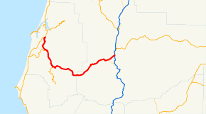
OR 39OR 42S →Oregon Route 42 is an Oregon state highway which runs between U.S. Route 101 on the Oregon Coast, near Coos Bay, and Green, a few miles south of Roseburg on Interstate 5. It is known as the Coos Bay-Roseburg Highway No. 35 (see Oregon highways and routes). At Coquille, there is a split in the route, as Oregon Route 42S heads southwest toward Bandon. The largest towns on the route are Winston, Coquille, Myrtle Point, and the unincorporated community of Green. Oregon Route 42 is the southernmost link between the Oregon Coast and the Interstate 5 corridor.
The section of Oregon Route 42 between its junction with U.S. Route 101 south of Coos Bay and its junction with Oregon Route 42S in Coquille was once a part of U.S. Route 101. When U.S. Route 101 was moved to an alignment closer to the ocean, Oregon Route 42 was extended along the northernmost section and Oregon Route 42S was created along the southernmost section.
Major intersections
- Note: mileposts do not reflect actual mileage due to realignments.
County Location Mile[1] Destinations Notes Coos 0.00 US 101 – Coos Bay, BandonInterchange Coquille 10.85 OR 42S – Bandon, Gold Beach23.48 Powers (OR 542) Interchange Douglas Winston 73.37 OR 99 south – Dillard, MedfordWest end of OR 99 overlap 76.22 OR 99 north – Shady, RoseburgEast end of OR 99 overlap 77.20  I-5 – Roseburg, Grants Pass
Interchange References
- ^ Oregon Department of Transportation, Public Road Inventory (primarily the Digital Video Log), accessed April 2008
Categories:- State routes in Oregon
- Transportation in Coos County, Oregon
- Transportation in Douglas County, Oregon


Wikimedia Foundation. 2010.