- Moor Park, Preston
-
Moor Park 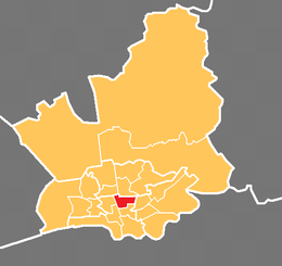
Shown within City of PrestonDistrict: City of Preston UK Parliament constituency: Preston Ceremonial county: Lancashire Region: North West Coordinates SD547303 Population (2001): 4,919 Councillors - David Borrows – Labour
- John Collins – Labour
Moor Park is a large park (approx 2 miles perimeter) to the north of the city centre of Preston, Lancashire, England. Moor Park is also the name of the electoral ward covering the park and the surrounding area. The ward borders the traditional boundary of Fulwood.
Contents
Park
 Moor Park, Preston
Moor Park lies to the north of Preston city centre on the A6 (Garstang Road), which forms the western boundary of the park. Blackpool Road between the A6 and Deepdale Road is the northern boundary. The latter forms the eastern side. Opposite the park on Deepdale Road is the Preston North End F.C.'s Deepdale stadium and National Football Museum.
Moor Park is Preston's largest and oldest park. The park was originally a farm and was run by George Dartford from a famous house called the Barn. In her book People's Parks (Cambridge University Press, 1991) Hazel Conway states that Moor Park is the first municipal park to be created in the newly-emerging industrial towns of Britain.
Preston Moor was an area of land to the north on Preston. It was originally common land derived from the Royal Forest of Fulwood by the Charter of Henry III in 1235.
In the 1830s it was felt by the town's council that Preston Moor was in a 'neglected and unprofitable condition'. In 1833 the Preston Chronicle published an article on 'The Intended Inclosure and Improvement of Preston Moor'. It showed a map of the intended enclosure. The plan was drawn up by the Town Steward, the appropriately named Philip Park.
The park was created by enclosing some 100 acres (40 ha) of the moor. A series of walks and 'drives' for horses and carriages were created, including an avenue of lime trees which was known for many years as 'the Ladies Walk'. This formed the southern boundary of the park. The northern boundary of the park was an avenue named the Serpentine Road because of it sinuous nature. Near the avenue was a body of water which was given the name the Serpentine Lake.
There was little public access to the enclosed area, which appears to mainly used for the grazing of animals and the growing of crops. A local brewer, Matthew Brown, grazed animals on the park for several years. Long after it use for grazing this area was known by locals as the 'Bull Field'. In 1862 there was a review of troops as part of the Preston Guild celebrations.
In the mid-1860s the park was landscaped to a design by the landscape architect Edward Milner and was part of a scheme to provide work for those unemployed because of the Lancashire cotton famine. Edward Milner was a former student and assistant of Joseph Paxton, the noted Victorian architect and park designer. The work was supervised by George Rowbotham, who later became the town's first Parks' Superintendent. These improvements cost £10,826.[1]
The work on the park involved the drainage of parts of the ground. New paths were created and shrubs and trees planted. The Serpentine lake was extended and a wooden bridge constructed over it. The supports of the bridge were constructed from Longridge stone. The same material was used to build a bridge in the north-west corner of the park.
The park was opened in October 1867. A large number of people, accompanied by bands, marched or were driven to the park. There they heard speeches by local dignitaries. As part of the celebrations there was a balloon flight from the eastern end of the park.
Improvements to the park included a cricket ground and among the teams that that played there was North End. They played on the park for several years then moved across Fulwood Road to a site at Deepdale. After a flirtation with rugby they began playing football. So began the long history of Preston North End F.C.
In the 1870s the park was the venue for the Annual Show of the Preston Agricultural Society. These shows drew large attendances by also some controversy. The refreshments tents were popular, but public drunkenness offended the supporters of Joseph Livesey and his Temperance movement.
By the late 1870s the wooden bridge over the Serpentine was in a dangerous state and was replaced by a metal framed structure. This was the scene of one of the park's tragic events. A small boy fell from the bridge while playing and was drowned.
In July 1885 the Royal Horticultural Society of England held its annual show on Moor Park with great success. One visitor to the show was the Prince of Wales, the future Edward VII.
In June 1887 a Military Review was held to held to celebrate Queen Victoria's Golden Jubilee. 340 men of the Gloucester Regiment and Royal Artillery trooped their colours. A Royal salute was fired.
 The Serpentine Lake
John Jenkinson was appointed the Park Keeper in 1890 after the death of John Singleton. He was paid 20s. a week, provided with a uniform and lived in the Garstang Road Lodge.
As part of the 1902 Preston Guild celebrations the Royal Lancashire Agricultural Society held its annual show on the park.
In June 1905 an open-air bath was opened in the park by Councillor W. H. Woods, who had for many years worked to provide additional swimming facilities in the town. The Preston Swimming Club provided an exhibition of swimming and life-saving techniques.
In 1908, Park School opened on Moor Park Avenue. It was one of the pioneer grammar schools for girls.
In 1913, Preston Grammar School moved to the eastern end of the Avenue from its site in Cross Street adjacent to Winckley Square.
During the First World War a hospital for the wounded was built. The earliest buildings were provided by the Royal Lancashire Agricultural Society. Hundreds of wounded soldiers were treated at the hospital. Some of the park was given over to the growing of food.
After the hospital was closed in 1919 the buildings were used as an open-air school until a new school was opened in 1937 on the same site.
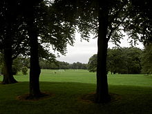
 Open fields in Moor Park
In the early 1920s Preston Council began construction of on an arterial road to improve transport in the area. This later became known as Blackpool road. The work required the widening of the Serpentine Road and the rearranging of the park's northern boundary. The latter was supervised by John Jenkinson. In August 1923, after returning home from a mornings work, he died of a heart attack.
In 1927 an observatory was built on the park to replace a building in Fulwood. It was named the Jeremiah Horrocks Observatory. The first curator was G. J. Gibbs, F.R.G.S.. The observatory is now run by the University of Central Lancashire, although light pollution and vibration from traffic on Blackpool Road means that it is no longer used for scientific research.
In the 1920s a bandstand was built close the bowling greens. Concerts by local musicians, such as Councillor Barton's Brass Band, had for many years attracted large audiences. Military bands were also crowd pleasers.
In 1932 a pavilion was opened on the park after many years of appeals for such a building to the council. Apart from the facilities for sportsmen it also had a cafe.
Cricket was very popular at the time. The Preston and District Cricket League had five Divisions. The highlight of the season for the League was the final of the Turner Cup competition, which was held many times on Moor Park. In the 1930s the competition was dominated by Waverley Cricket Club.
During the Second World War the park was enjoyed by families who were encouraged to 'Holiday at Home'. A part of the park was given over to the growing of food. It was reputed to be the site of a prisoner-of-war camp but confirmation of this is required.
Moor Park was used as a petrol dump during the war. It was kept underground at the Deepdale Road end. German prisoners of war were kept in the North End F.C Pavilion situated in front of the ground in Lowthorpe Road; A road with semi-detached houses built in 1928. The ground itself was used for the prisoners to exercise. Two British soldiers with rifles were on guard day and night in front of the pavilion. In the Kimberley Territorial Barracks situated next of the F.C and across from the main gates of the park on Deepdale Road ,Italian prisoners of war were kept and American soldiers were billeted there.The Italians could be seen in the exercise ground behind the barracks from the walkway next to the football ground which links Deepdale Road to Lowthorpe Road . Having more freedom than the Germans the Italians could be seen through the tall secure fence by neighbours as they frequently used the short cut home from the bus stop at Moor Park Gates. As the war progressed the spare land of the F.C next to Deepale Road was used by convoys of army lorries making overnight stays en-route south building up to much activity as D. Day approached.
After the war the A.T.S. buildings where occupied by people who were looking for homes and who were described as 'squatters'.
In 1965 Bob 'Willie' Wilson attempted to win a prize for the first man-powered flight. He owned a bicycle shop in Ribbleton and, not surpringly, his machine incorporated the technology he was familiar with. His machine was called the 'Gyro-Bike'. Sadly Wilson and the spectators were disappointed.
In 1969, Park School and Preston Grammar School closed to become part of the Sixth Form College amidst much protest.
In the early 1970s the open-air swimming pool was closed and filled in.
In 1976 the pavilion was destroyed in a fire. It was replaced at a cost of £50,000, but the new building was a more utilitarian structure.
In 1977 Tom Benson broke the world long distance walking record by walking 314.33 miles round Moor Park. A stone recording his achievement can be seen near the Garstang Road entrance to the Avenue.
During the 1980s The Serpentine was reduced in size and the bridge dismantled. The stone piers remain.
In 2002 a 'Friends of Moor Park' group was created. The aim of the group is to support the running of the park.
On the weekend of the 19 and 20 May 2007 the 2007 Radio 1's Big Weekend took place at Moor Park. With 3 stages and an estimated 35,000 people attending, it was the biggest free ticketed music festival in Europe.
The park now contains football pitches, cricket creases, bowling greens, tennis courts, basket ball courts, a netball court, a bowls pavilion, and a football pavilion.[1]
The Moor Park Business and Enterprise School now occupies the buildings of Preston Grammar School. A campus of Preston College moved into the Park School buildings. The Sir Tom Finney Community High School is located near the Serpentine on Blackpool Road.
In 2009, the park played host to the beginnings of student football fixtures. In 2010, the league has been rejuvenated by UCLan to host the inaugural student league on what is now known as 'The Theatre of Dreams'.
In 2011 Preston College closed the campus in the old Park School building. The building will be demolished and housing built. The announcement was greeted with sadness by some of the pupils who had studied there.
With the 2012 Preston Guild being planned, Moor Park will play an important role in the celebrations. Work began in late 2011 to improve the park.
Plans for a a new BMX and skateboard area to be created in the north eastern corner of the park have been announced.
Electoral ward
Moor Park is currently a two-member electoral ward, which in addition to the neighbouring College and Deepdale wards, forms the Preston Central North division of Lancashire County Council. The English Martyr’s Catholic Church is within the ward.
Current councillors
Election Member Party Preston Council election, 2007 Frank De Molfetta Labour Party Preston Council election, 2010 John Collins Labour Party Demographics
At the 2001 census, Moor Park has a population of 4,919, whilst at the most recent election the electorate was 3,053. Of this figure, 68% described themselves as Christian, with a Muslim population of 5.2%. Whilst the area around Fulwood is largely commuter belt and recent retired properties, the Plungington and Deepdale areas are traditional terraces with multi-occupancy homes increasingly common.
Geography
The traditional “grid” terraces in the south of the ward are made up of a number of main roads, including the A6 Garstang Road which itself runs from the ward’s northern boundary at Lytham Road, to the outskirts of the city centre. The component of the electoral ward to the south of Moor Park itself crosses the A6 to take in a number of terraces to St Paul’s Road in an easterly direction towards Deepdale. From the main Blackpool Road heading north, the houses are largely semi- and true detached homes in the suburban style.
Notes
[2] Open-air-bath for Preston - an interesting ceremony. Preston Guardian. 10 June 1905. p. 13.
[3] New sports pavilion at Moor Park. Preston Guardian. 28 May 1932. p. 6.
References
- ^ a b "Moor Park". Preston City Council. http://www.preston.gov.uk/Category.asp?cat=1681. Retrieved 29 November 2008.[dead link]
External links
See also
Categories:- Wards of Preston
- Parks and commons in Preston
- Urban public parks


Wikimedia Foundation. 2010.