Custis Trail

Custis Trail
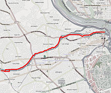
map of the Custis Trail

The Custis Trail is a 4-mile, paved bike trail in Arlington County, Virginia that extends from Key Bridge at Rosslyn westward to the Washington & Old Dominion Railroad Trail.[1] It connects at its east end to the Mount Vernon Trail, which continues east and south along the Potomac River to Mount Vernon and at its west end to the Washington & Old Dominion Railroad Trail, which continues northwest to Purcellville, Virginia.

The Custis Trail was built alongside Interstate 66 (named the Custis Memorial Parkway in Virginia east of the Capital Beltway).[2] The trail opened in the early 1980s at the same time that the highway did. Because the trail directly connects to the Key Bridge into Georgetown and to the Mount Vernon Trail, which provides easy access to the other three downtown river crossings, it is a popular bicycle commuter route.

References and notes

External links

Coordinates: 38°53′14″N 77°07′02″W / 38.887239°N 77.117361°W / 38.887239; -77.117361


Wikimedia Foundation. 2010.

Игры ⚽ Нужен реферат?

Look at other dictionaries:

  • Custis — can refer to: Daniel Parke Custis, son of John Custis and first husband of Martha Dandridge Custis Washington Eleanor Parke Custis, adopted daughter of George Washington George Washington Parke Custis, son of John Parke Custis and adopted son of… …   Wikipedia

  • Mount Vernon Trail — Map of the Trail The Mount Vernon Trail is a popular running and bike path in Northern Virginia that follows the west bank of the Potomac River from near Theodore Roosevelt Island to Mount Vernon. The northern, urban half is open and has views of …   Wikipedia

  • Bluemont Junction Trail — The Bluemont Junction Trail is a 1.8 mile rail trail in Arlington County, Virginia. It connects Bluemont Junction Park, where it meets the Washington Old Dominion Trail, to Ballston. In Ballston there are direct bike lanes into the City via… …   Wikipedia

  • Washington and Old Dominion Railroad — The Washington and Old Dominion Railroad (colloquially referred to as the W OD) was an intrastate short line railroad located in Northern Virginia. Its oldest line extended from Alexandria on the Potomac River northwest to Bluemont at the foot of …   Wikipedia

  • Washington & Old Dominion Railroad Regional Park — The Washington Old Dominion Railroad Regional Park is a popular and unusually shaped regional park in Northern Virginia. The park s primary feature is the Washington Old Dominion Railroad Trail (abbreviated as W OD Trail), an asphalt surfaced… …   Wikipedia

  • Rosslyn, Arlington, Virginia — Rosslyn is an unincorporated area in Northern Virginia located in the northeastern corner of Arlington County, Virginia, north of Arlington National Cemetery and directly across the Potomac River from Georgetown in Washington, D.C. Rosslyn… …   Wikipedia

  • Great Falls and Old Dominion Railroad — The Great Falls and Old Dominion Railroad (GF OD) was an interurban trolley line that ran in Northern Virginia during the early 20th century.HistoryChartered in 1900 by John Roll McLean (owner of The Washington Post ) and Senator Stephen Benton… …   Wikipedia

  • Four Mile Run — Infobox River | river name = Four Mile Run caption = Four Mile Run at Arlington s Bon Air Park origin = Fairfax County, Virginia (paved over) mouth = Potomac River in Arlington County, Virginia basin countries = United States length = 9 mi… …   Wikipedia

  • Northern Virginia trolleys — Terminal at Mount Vernon Operation Began operation 1892 Ended operation …   Wikipedia

  • Arlington House, The Robert E. Lee Memorial — U.S. National Register of Historic Places U.S. National Memorial …   Wikipedia

Share the article and excerpts

Direct link
Do a right-click on the link above
and select “Copy Link”