- Menomonee River
-
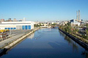 View of Menomonee River looking east from the James E. Groppi Unity Bridge (a.k.a. 16th Street Viaduct).
- See also Menominee River.
The Menomonee River is one of three primary rivers in Milwaukee, Wisconsin.
Contents
Description
Named after the Menomonee (also spelled Menominee) Indians, the word literally means "good seed", referring to the abundant wild rice that once grew along its shores in the Menomonee Valley. A tributary of the Milwaukee River, it is the most industrialized within the Milwaukee River Basin.
Watershed
The Menomonee River is 33.0 miles (53.1 km) long,[1] with a watershed that covers approximately 140 square miles (360 km2) of urban landscape and is home to a population of more than 336,670 people. This includes portions of Washington, Ozaukee, Waukesha, and Milwaukee counties. A large swath of the river has been heavily channelized and industrialized as it runs through the Menomonee Valley. This has become a primary source of pollution for the river.
Its estuary empties into Lake Michigan from the Milwaukee River near the Milwaukee harbor, along with the Kinnickinnic River to the south.
References
- ^ U.S. Geological Survey. National Hydrography Dataset high-resolution flowline data. The National Map, accessed May 19, 2011
External links
- Milwaukee Riverkeeper
- Great Lakes Tributary Program
- Menomonee Valley Partners
- Milwaukee River Basin Partnership
Categories:- Geography of Washington County, Wisconsin
- Geography of Waukesha County, Wisconsin
- Geography of Milwaukee, Wisconsin
- Rivers of Wisconsin
- Tributaries of Lake Michigan
- Wisconsin geography stubs

Wikimedia Foundation. 2010.