- Nineteen Counties
-
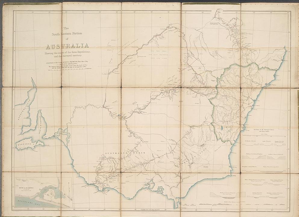
 The South Eastern Portion of Australia; compiled from the Colonial Surveys, and from details furnished by Exploratory Expeditions. Detailed map of New South Wales, issued in the London Atlas by John Arrowsmith. The "newly formed" counties are marked, as are the inland expeditions made 1817-1840.
The Nineteen Counties were the limits of location in the colony of New South Wales defined by the Governor of New South Wales Sir Ralph Darling in 1826 in accordance with a government order from Lord Bathurst, the secretary of State. Counties had been used since the first year of settlement, with Cumberland County proclaimed on June 6, 1788. Several others were later proclaimed around the Sydney area. A further order of 1829 extended these boundaries to an area defined as the Nineteen Counties. Settlers were only permitted to take up land within the defined area. From 1831 there were no more free land grants and the only land that was for sale was within the Nineteen Counties.
The area covered by the limit extended to Kempsey in the north, Batemans Bay in the south and Wellington to the West.
The Nineteen Counties were mapped by the Surveyor General Major Thomas Mitchell in 1834. The scale of the map that Mitchell produced was determined by the amount of ship's copper available in Sydney to engrave the map. [1]
Despite the uncertainty of land tenure, squatters ran large numbers of sheep and cattle beyond the boundaries. From 1836 they could legally do so, paying ten pounds per year for the right. From 1847 leases in the unsettled areas were allowed for up to 14 years. The Robertson Land Acts of 1861 allowed free selection of crown land and the limits of location were redundant. The counties continue to be used for the purposes of cadastral divisions, and the rest of New South Wales was likewise divided into counties, totalling 141 by the end of the nineteenth century.
Contents
Background to formation of the limits of settlement
 1838 map by Surveyor-General, Thomas Mitchell of Victoria and New South Wales showing towns, major rivers and the limits of the Colony at the time. The map also shows the routes taken by Mitchell's expedition and camps.
In January 1819 John Bigge was appointed a special commissioner to examine the government of the colony of New South Wales. Bigge arrived in Sydney in September 1819 gathering evidence until February 1821 when he returned to England. Bigge’s first report was published in June 1822 and his second and third reports in 1823. His third report dealt with Agriculture and Trade.
In 1824 Governor Brisbane approved the sale of crown land in accordance with one of Bigge’s recommendations. Previously only a nominal ‘quit’ rent was required for grants by the crown.
In 1825 Lord Bathurst, secretary of state, instructed Governor Brisbane to survey the territory to allow for more planned settlement. During the survey one seventh of the land in each county was to be set a side for the Church of England and an educational system under the control of the church. Income from this land was to be managed under the Church and Schools Corporation.
When Governor Darling was commissioned in July 1825 his commission extended the New South Wales boundary six degrees to the west compared with the commissions issued to previous governors.
In September 1826 Darling announced the boundaries within which the survey instructed by Bathurst in 1825 was to be conducted. The survey would allow the allocation of land grants and the boundaries, known as the limits of location, were used for other administrative purposes including police administration.
The nineteen counties were proclaimed by Darling in the Sydney Gazette of 17 October 1829. The boundaries were the Manning River to the north, the Lachlan river to the west and the Moruya river to the south. In some places there were already squatters beyond these ‘limits of location’.
The Nineteen Counties
- Gloucester: northern-most boundary was the Manning River; the county incorporated Port Stephens
- Durham: west of Gloucestor, southern Boundary was the Hunter River
- Northumberland: northern boundary was the Hunter River and the southern boundary was formed by the Hawkesbury River
- Cumberland: incorporated Sydney, Windsor, Parramatta, Liverpool and Appin to the south
- Camden: included Camden, Picton and Berrima with the southern-most border defined by the Shoalhaven River
- St Vincent: from the Shoalhaven River south to the Moruya River, included Jervis Bay, Batemans Bay and Braidwood
- Hunter County: west of the county of Northumberland, bounded by the Hunter River to the north
- Cook: west of Cumberland county and south of the county of Hunter
- Westmoreland: west of the counties of Cook and Camden
- Georgiana: west of the county of Westmoreland
- King: north of the county of Murray and west of the counties of Argyle and Georgiana
- Murray: incorporating the Limestone Plains and Lake George, bounded by the Murrumbidgee River to the west, the south western extent of limits of settlement
- Argyle: west of Camden county, included Goulburn, bounded by the Shoalhaven River to the south east
- Roxburgh: north east of the county of Bathurst, west of the counties of Cook and Hunter
- Bathurst: bounded by the Lachlan River to the south west, incorporating the town of Bathurst, west of the counties of Roxburgh and Westmoreland
- Brisbane: north of the Hunter River, west of the county of Durham, one of the northern-most counties
- Phillip: west of the county of Hunter and north of Roxburgh
- Wellington: north of Bathurst, the town of Wellington was in the northwest of the county and the Macquarie River flowed through the middle
- Bligh: the north-westernmost county, north of the county of Phillip and west of the county of Brisbane
See also
References
Notes
- ^ Canberra's Engineering Heritage, William Charles Andrews, Institution of Engineers, Canberra, 1990 p3
Categories:- History of New South Wales
- Counties of New South Wales

Wikimedia Foundation. 2010.