- Collaroy Plateau, New South Wales
-
Collaroy Plateau
Sydney, New South Wales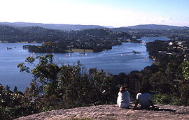
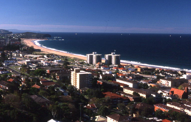
View to the north from Collaroy PlateauPostcode: 2097 Location: 22 km (14 mi) north-east of Sydney CBD LGA: Warringah Council State District: Pittwater, Wakehurst[1] Federal Division: Mackellar[2] Suburbs around Collaroy Plateau: Narrabeen Lagoon Narrabeen Wheeler Heights Collaroy Plateau Collaroy Cromer Collaroy Plateau is a suburb of northern Sydney, in the state of New South Wales, Australia. Collaroy Plateau is located 22 kilometres north-east of the Sydney central business district, in the local government area of Warringah Council and is part of the Northern Beaches region.
Collaroy Plateau was designated as a separate suburb in 1977 with a postcode of 2097, but was reassigned as a locality within Collaroy in 1984. In 2001, all localities were renamed Urban Places. In 2011, Collaroy Plateau, along with Wheeler Heights, was re-established as a suburb by the Geographical Names Board of NSW, after lobbying by the community, who had never ceased considering it to be a suburb since its loss of that title in 1984.[3]
Collaroy Plateau is home to the public primary school Collaroy Plateau Primary School.[4]
Collaroy Plateau homes some of the most far reaching views on the Northern Beaches. Various parts of Collaroy Plateau overlook Collaroy Beach, Long Reef Beach, Narrabeen Beach and Narrabeen Lagoon.
References
- ^ "State Electoral Office search results". NSW State Electoral Office. http://www.elections.nsw.gov.au/state_government_elections/electoral_districts/district_search?queries_locality_query=collaroy+plateau&search_page_15142_submit_button=Search&queries_post_code_query=¤t_result_page=0&results_per_page=0&submitted_search_category=&mode=. Retrieved 2006-12-10.
- ^ "AEC Polling Places". Australian Electoral Commission. http://apps.aec.gov.au/esearch/LocalitySearchResults.aspx?filter=collaroy+plateau&filterby=Locality. Retrieved 2006-12-10.
- ^ "Collaroy Plateau". Geographical Names Board of NSW. http://www.gnb.nsw.gov.au/name_search/extract?id=MnIOBKUlIt. Retrieved 2011-05-06.
- ^ "Collaroy Plateau Public School". http://www.collaroypl-p.schools.nsw.edu.au/ContactUs.html. Retrieved 2007-06-27.
 View of Narrabeen from Collaroy Plateau
External links
Suburbs of Warringah Council | Northern Beaches | Sydney Allambie Heights · Beacon Hill · Belrose · Brookvale · Collaroy · Collaroy Plateau · Cottage Point · Cromer · Curl Curl · Davidson · Dee Why · Duffys Forest · Forestville · Frenchs Forest · Freshwater · Ingleside · Killarney Heights · Manly Vale · Narrabeen · Narraweena · North Balgowlah · North Curl Curl · North Manly · Oxford Falls · Queenscliff · Terrey Hills · Wheeler HeightsList of Sydney suburbs Categories:- Suburbs of Sydney
- Sydney geography stubs

Wikimedia Foundation. 2010.