- Clareville, New South Wales
-
Clareville
Sydney, New South Wales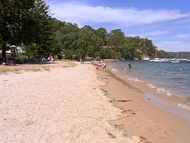
Clareville BeachPostcode: 2107 Location: 36 km (22 mi) north-east of Sydney CBD LGA: Pittwater Council State District: Pittwater Federal Division: Mackellar Suburbs around Clareville: Avalon Avalon Scotland Island Clareville Bilgola Newport Newport Clareville is a suburb in northern Sydney, in the state of New South Wales, Australia. Clareville is located 36 kilometres north-east of the Sydney central business district, in the local government area of Pittwater Council. Clareville is part of the Northern Beaches region.
Clareville is bordered by Avalon, Bilgola and Newport. Clareville Beach and Taylors Point are localities within the suburb. Bilgola Plateau is an adjoining locality in the suburb of Bilgola.
History
In the 1830s, two large land grants were made to a priest, Father John Joseph Therry, part of which was what is now known as Clareville. It is thought that the suburb has historically been accessed by the water. In the early 1920s, the area was subdivided and Sydney residents purchased holiday homes. In the 1950s, with the increase in motor car use, the area became a residential zone.[1] Houses in the area are now expensive, with many having water frontages and views.
References
- [1] Pittwater Library Studies group information page
External links
- Clareville, New South Wales is at coordinates 33°38′04″S 151°18′57″E / 33.63440°S 151.31594°ECoordinates: 33°38′04″S 151°18′57″E / 33.63440°S 151.31594°E
- Information about Father John Joseph Therry
Suburbs and Localities of Pittwater Council | Northern Beaches | Sydney Akuna Bay · Avalon · Barrenjoey · Bayview · Bilgola · Church Point · Clareville · Coasters Retreat · Currawong Beach · Elanora Heights · Elvina Bay · Great Mackerel Beach · Ingleside · Lovett Bay · Mona Vale · Narrabeen · North Narabeen · Newport · Palm Beach · Scotland Island · Taylors Point · The Basin · Towlers Bay · Warriewood · Whale Beach
Categories:- Suburbs of Sydney
- Sydney geography stubs

Wikimedia Foundation. 2010.