- Dora Creek, New South Wales
-
Dora Creek
New South Wales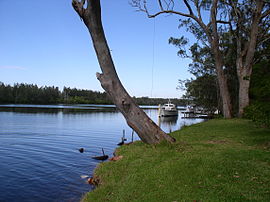
Scenery from the bank of Dora Creek.Population: 1312 (2006 census) Postcode: 2264 Area: 2.3 km² (0.9 sq mi) Location: LGA: City of Lake Macquarie Parish: Coorumbung State District: Lake Macquarie Federal Division: Charlton Coordinates: 33°04′55″S 151°30′04″E / 33.082°S 151.501°E
Dora Creek is a small rural suburb of the City of Lake Macquarie in New South Wales, Australia, located west of Lake Macquarie in New South Wales and north of the town of Morisset.
Dora Creek is named for the creek running through its centre, and was originally known as Doree Doree in the local Aboriginal language, which means "Creek running into a lake".
The Lake Macquarie Council has placed emphasis on the Dora Creek environment, carrying out major forshore restoration works, and educating the public about the protection of creeks and waterways. It is known for its beautiful scenery and proximity to the Watagan Mountains. It is convenient to the Sydney-Newcastle Freeway and Dora Creek Railway Station.
References
Other resources:
- Cooranbong, first town in Lake Macquarie, 1826–1996: a history including Martinsville and Dora Creek by Michael Chamberlain (description). ISBN 0646329588
- History of Dora Creek from Lake Macquarie Information Hunter
Categories:- Suburbs of Lake Macquarie
- Lake Macquarie geography stubs

Wikimedia Foundation. 2010.