- Wanniassa, Australian Capital Territory
Infobox Australian Place | type = suburb
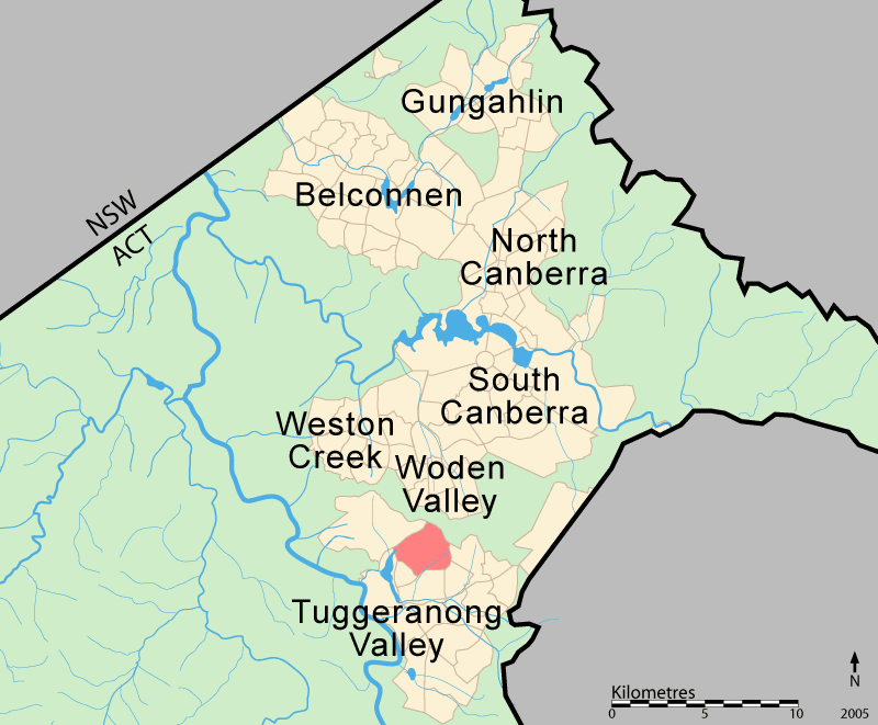
name = Wanniassa
state = Australian Capital Territory
city = Canberra
caption =
lga = Tuggeranong
postcode = 2903
est = 1975
propval = AU$327,000 (2005) [http://allhomes.com.au/c/ah?a=uisu&i=798]
pop = 7,933 (2006 census)
ACTgov = Brindabella
fedgov = Canberra
near-nw = Kambah
near-n = Farrer
near-ne = "Nature reserve"
near-e = Fadden
near-w = Greenway
near-sw = Oxley
near-s = Monash
near-se = GowrieWanniassa (postcode 2903) is a suburb in the
Canberra ,Australia district of Tuggeranong. It is located towards the north of the district. The suburb is named after an early local name for the Tuggeranong district. The Wanniassa estate was founded in1835 . The suburb was gazetted on21 May 1974 . Streets are named after Victorian state politicians.It is next to the suburbs of Kambah, Greenway, Oxley, Monash, Gowrie and Fadden. It is bounded by Athllon Drive, Sulwood Drive, Erindale Drive and Taverner Street.
Demographics
There were 7,933 people living in Wanniassa on Census night 2006. The median age of people in Wanniassa was 36 years, compared to a median age of 34 for Canberra. The median individual income for Wanniassa in 2006 was $669, below the Canberra average of $723, while the median household income was $1,474. In 2006, the median monthly housing loan repayment in Wanniassa was $1,343.Census 2006 AUS|id=805258379|name=Wanniassa (Statistical Local Area)|accessdate=2007-06-30|quick=on]
The residents of Wanniassa are predominately Australian born, with 75.3% being born in Australia. The three main countries of birth for those born overseas were
United Kingdom , 6.0%,New Zealand , 1.1%, andItaly , 0.8%. The most popular religious affiliations in decending order are Catholic, no religion, Anglican, Uniting, andPresbyterian .uburb amenities
A wide variety of facilities are located in Wanniassa. The
Erindale Centre is located in the south east of Wanniassa and provides a number of service and retail outlets. Other facilities include [http://www.tuggers.com.au/default.asp?d=12025&p=12020 Erindale Vikings Club] , [http://www.activelc.com.au/ Active Leisure Centre] , the Erindale Theatre and the [http://www.library.act.gov.au/mylibrary/locations/erindale Erindale Library] . The Wanniassa Centre is a smaller retail centre located at the north of the suburb, housing aSupabarn Supermarket and various other businesses.Several educational facilities are located in Wanniassa.
Erindale College is a public college serving students in Years 11 and 12. The College is integrated into and makes use of the various other facilities in Erindale. [http://www.whps.act.edu.au/home Wanniassa Hills Primary School] is located on Langdon Avenue; it is a public primary school servicing students from Kindergarten to Year 6. [http://www.wans.act.edu.au/ Wanniassa School] is a public primary and high school with adjacent campuses serving students from Pre-School to Year 6 and Year 7 to Year 10. The junior campus of MacKillop Catholic College is located in Wanniassa, serving students from Year 7 to Year 9. Another Catholic school, [http://www.stanthonys.cg.catholic.edu.au/ St Anthony's Parish Primary School] , is also located in Wanniassa and serves Kindergarten to Year 6 students. [http://www.tcs.act.edu.au/ Trinity Christian School] is an independent Christian school serving students from Kindergarten to Year 12.Several churches are located in Wanniassa. [http://www.users.bigpond.com/stanthonys.wanniassa/ St Anthony of Padua Parish] is a Catholic parish that was established in 1976; services were held at Wanniasa Primary School and Padua High School - later MacKillop Catholic College - before the church adjacent to Mckillop Catholic College was completed in 1987. [http://www.stmattswanniassa.org.au/ St Matthew's Anglican Church] is located adjacent to Trinity Christian School on McBryde Crescent. [http://www.tuc.org.au/ Tuggeranong Uniting Church] , [http://www.capitaledge.org.au/ Capital Edge Community Church] (formerly known as Erindale Christian Centre) and [http://www.lifestreamcf.org.au/ Lifestream Christian Fellowship] are all located in or adjacent to the Erindale Centre. [http://www.ccctuggeranong.org.au/ Christian City Church Tuggeranong] offers services at the hall of Wanniassa School Senior Campus while they await the construction of a more permanent building in Monash.
In addition to the Active Leisure Centre, sporting facilities in Wanniassa include the Wanniassa Enclosed Oval, the Wanniassa District Playing Fields, the Erindale Playing Fields and the Erindale tennis courts.
Wanniassa is serviced by several
ACTION bus routes. Routes 61, 63 and 64 run between the Tuggeranong and Woden Interchanges every twenty to sixty minutes from approximately 7:00 a.m. to approximately 7:00 p.m. The additional service 161 runs from the Tuggeranong Interchange to City West once during the morning peak hour and once in the other direction in the evening peak hour. Route 63 extends to Campbell Park Offices during the morning and evening peak hours. Flexibus Service 964 leaves the Tuggeranong Interchange every hour from 8:20 p.m. to 11:20 p.m. and the Erindale Shops every hour from 8:50pm to 10:50 p.m., and services the suburbs of Wanniassa, Monash and Oxley. Several other routes that service other Tuggeranong suburbs also stop at the Erindale Centre. [ACTION Buses(2006) [http://www.action.act.gov.au/ ACTION Buses] , retrieved 9 September 2006 ]Geological features
Wanniassa is underlain by Deakin Volcanics from the
Silurian age 414 million years old - cream-green and purplerhyodacite in the eastern half, withtuff ,agglomerate andrhyolite in the west. [Henderson G A M and Matveev G, Geology of Canberra, Queanbeyan and Environs 1:50000 1980.]Gardeners have to deal with a high proportion of clay soils leading to poor drainage which can be a problem, especially for those in the hillier parts of the suburb.Fact|date=January 2008
References
Wikimedia Foundation. 2010.