- North American blizzard of 1996
-
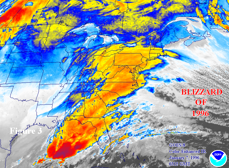
North American blizzard of 1996 Satellite image of the storm system on January 7, 1996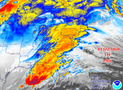
Storm type: Winter storm Formed: January 6, 1996 Dissipated: January 10, 1996 Maximum
amount:*48 inches (120 cm), Pocahontas County, West Virginia Lowest
pressure:unknown Damages: Roughly $3 billion Fatalities: 154 total (another 33 took place during flooding after the storm) Areas affected: Continental United States; especially the Northeastern United States ^* Maximum snowfall or ice accretion
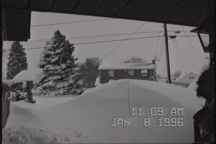
The Blizzard of 1996 was a severe nor'easter that paralyzed the U.S. East Coast with up to 4 feet (1.2 m) of wind-driven snow from January 6 to January 8, 1996. It was followed by another storm on January 12th, then unusually warm weather and torrential rain which caused rapid melting and river flooding.
Contents
Impact
Washington D.C. and Baltimore
Snow began falling on Washington, D.C. and Baltimore during the late evening of January 6 and continued at a consistent rate until mid-afternoon the next day. At that time, the metro area received 13 to 17 inches (33 to 43 cm), and after a few hours of sleet and then a complete stop for several hours, it seemed the worst was over. But overnight, as the storm slowly crawled northward, extremely heavy bands of snow came in from the east. These bands created whiteout conditions as winds gusted past 40 miles per hour (64 km/h), along with thunder and lightning. By the morning of January 8, the bands tapered off, and the metro area was left with a blanket of 15 to 25 inches (38 to 63 cm) of snow. Baltimore received 22.5 inches (57 cm) and Washington Dulles International Airport received 24.6 inches (62 cm). Many areas north and west in Maryland and West Virginia received well over 2 feet (0.6 m) with a few locations in the mountains of West Virginia and Virginia receiving up to 4 feet (1.2 m).
Because of unseasonably warm weather in mid-January, the snow melted quickly and caused the worst winter flooding in decades for river and stream valleys from Southwest Virginia to New York.[1]
Philadelphia
Snowfall accumulations averaged 20 to 22 inches in Monroe and Carbon Counties, around 2 feet in Lehigh and Northampton Counties, 24 to 33 inches in Berks County, 20 to 26 inches in Chester and Delaware Counties, 20 to 30 inches in Montgomery and Bucks Counties and 27 inches in Philadelphia. Other individual accumulations included 33 inches in Ontelaunee Township (Berks), 30 inches in Reading (Berks) and Palm and Souderton (Montgomery), 28 inches in Perkasie (Bucks), 27 inches in Philadelphia (Franklin Institute) and 26 inches in Glenmoore (Chester).
30.7 inches (78 cm) of snow fell in Philadelphia, the most of any major city in the storm's path. It was the city's all-time greatest snowstorm, compared to its previous greatest snowstorm which was a "mere" 21.3 inches. Most of those 30.7 inches, 27.6, fell in just 24 hours, a new record for the city for the most snow in 24 hours. The mayor declared a state of emergency, and only police and other emergency workers were permitted to drive on city streets leaving the city to pedestrians.
For three days city trucks loaded with plowed snow dumped their contents into the Schuylkill and Delaware rivers eventually causing major problems with the natural flow of the rivers. It is a rare occurrence for trucks to "dispose of snow" in the Philadelphia area, since the snowfall amounts typically do not warrant it. However the snow was so extensive, that plowing would cause massive snow piles. City officials had no choice but to resort to hauling the snow to nearby rivers. Disposal of snow became a major issue but temperatures quickly returned to normal and began to quickly clear the snow. This resulted in flooding, when on January 19th, a jet stream disturbance from the Gulf of Mexico caused a rapid melt, followed by thunderstorms, which both brought three inches of rain, and caused the snow to melt 20 inches in one day; or equivalent to 2 inches of rain. Philadelphia saw its worst flooding in twenty years. Damages were estimated to reach $1 billion.[1]
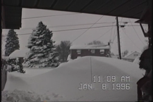 Blizzard of 1996, Temple, Pennsylvania.
New Jersey
Snow began falling during the predawn hours of the 7th and became heavy at times during the morning. Blizzard conditions developed during the afternoon and evening as strong northeast winds developed around the intensifying low pressure. During the afternoon hours, precipitation in far southern New Jersey changed to sleet and freezing rain as the low brought in warm air at mid-levels, but remained all snow across the rest of the state. During the evening and overnight hours the snow mixed with sleet as far north as central sections of the state as the low center approached the state from the south. A lull developed in the precipitation in the pre-dawn hours of the 8th as the low center was just off the New Jersey coast, but wraparound moisture brought another period of snow to the state as the low pulled away during the later morning and early afternoon hours of the 8th. Accumulations averaged 24 to 27 inches in Sussex County, 20 to 27 inches in Warren County, 23 to 28 inches in Morris County, generally 20 to 30 inches in Bergen, Passaic, Union, Hudson, Essex, Hunterdon, Somerset, Mercer, and Monmouth counties, 19 to 32 inches in Middlesex County, 18 to 31 inches in Burlington County, 16 to 24 inches in Salem, Gloucester, and Camden counties, 24 inches inland and 10 to 14 inches at the coast in Ocean County, and 10 to 18 inches in Cumberland, Atlantic, and Cape May counties. In addition to the heavy snow, wind gusts reached hurricane force along the coast during the evening of the 7th, with an 81 mph gust recorded in Ocean Grove. While accumulations were lighter along the shore, the strong northeasterly flow produced moderate coastal flooding at the time of high tide on the evening of the 7th, with tides 3 to 4 feet above normal. The tide reached 7.5 feet above mean low water in Atlantic County and 8.5 feet above mean low water in Cape May County. Fortunately, winds switched to the northwest before worse flooding could occur at high tide on the morning of the 8th.
The state of New Jersey recorded its second-largest snowstorm at Edison, where 32 inches (81 cm) fell (the greatest single storm record being 34 inches (86 cm) at Cape May in the Great Blizzard of 1899). Elizabeth, New Jersey also reported 32 inches of snow. Newark, the state's largest city, received a record-setting 27.8 inches (71 cm), while Trenton, the capital, received 24.2 inches (61.5 cm). All roads in the state were closed, including the entire length of the New Jersey Turnpike for the first time in that road's history. Over two-thirds of the state was buried under 2 feet (61 cm) of snow, making this storm the state's most paralyzing snowstorm of the 20th century. Places such as Roselle and Linden received around 30 inches. New Jersey was, along with other states, put into a state of emergency.
New York City
New York City's Central Park officially recorded 20.2 inches (51 cm) for its fourth-largest single snowfall (records going back to 1869), but many locations in the other boroughs and suburbs recorded over 30 inches (76 cm) of snow. Schools in New York City's boroughs closed due to snow for the first time since the Blizzard of 1978, 18 years earlier. While most suburban districts in the area close for snow several times each winter, in the city itself they rarely do because of relatively easy access to underground subways whose ability to run is not appreciably affected by snowstorms of moderate to large accumulation; however, in this snowstorm, the transit network did shut down.
New England
Providence, Rhode Island received 24 inches (61 cm) of snow, while Boston and Hartford, Connecticut both received 18.2 inches (46 cm). Up to 33 inches (84 cm) of snow fell in the Berkshire Mountains of western Massachusetts and the northern hills of Connecticut. While this was a major snow event for southern New England, the Blizzard of 1996 was not as intense as other recent events, notably the Blizzard of 1978 and the March 1993 Superstorm. Snowfall amounts decreased sharply as one moved further north, with northern Vermont, New Hampshire, and Maine receiving little more than snow flurries from this event. It even broke a bridge over the Connecticut River in Springfield and West Springfield, Massachusetts.
Status as a blizzard
Despite the storm's common name as the "Blizzard of 1996", one of the few observing sites to record true blizzard conditions was Trenton-Mercer Airport near Trenton, New Jersey. During the afternoon of January 7, the airport recorded the necessary three consecutive hours of frequent wind gusts to at least 35 miles per hour (56 km/h) combined with a prevailing visibility consistently below 0.25 miles (400 m) along with falling and blowing snow, meeting the official NWS standard of a blizzard. All other New Jersey observing sites, as well as most sites in neighboring states, failed to observe true blizzard conditions, though many stations did observe blizzard conditions for less than the necessary three consecutive hours. By and large, however, the storm was not a real blizzard in the technical sense.
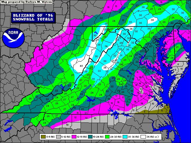
Snowfall accumulation totals
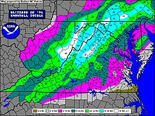 Blizzard of 1996 Mid Atlantic Snowfall accumulation.(By National Weather Service in Sterling, Virginia)
State City/location Amount (inches) VA Big Meadows 47 WV Pocahontas County 40-48 VA Stanley 42.0 PA York County 35-40 MD Takoma Park 36 PA Shippensburg 35 MA Berkshire County 33 CT Litchfield County 33 VA Luray 33 MD Frostburg 32 NJ Edison 32 VA Front Royal 32 NJ Bordentown 31 PA Philadelphia 30.7 NJ Raritan 30 NJ White House Station 30 NJ Howell 30 NJ Moorestown 30 NJ Hazlet 29.8 NJ Elizabeth 28.8 NJ Freehold 28 NJ Newark 27.8 NJ McGuire Air Force Base, Wrightstown 27 NC Boone 26 NJ Califon 26 PA Allentown 25.9 VA Dulles International Airport 24.6 NJ Lambertville 24.8 NJ Bound Brook 24.5 NJ Trenton 24.2 NJ Pottersville 24 RI Providence 24[2] NJ Long Branch 24 NJ Toms River 24 MD Baltimore 22.5 NJ New Brunswick 22.6 VA Roanoke 22.2 NJ Sandy Hook 22 NJ Mount Holly 22 NJ Flemington 20.3 NY Central Park, New York City 20.2 NJ Plainfield 19 MA Boston 18.2[2] CT Hartford 18.2[2] NJ Willingboro 19.4 NJ Marlton 18 NJ Princeton 18 VA National Airport, Washington, D.C. 17.1 NJ Hightstown 17.1 CT Bridgeport 16 NJ Somerville 16 NJ Indian Mills 16 NJ Beach Haven 15 NC Hickory 14 VA Richmond 11.5 NJ Cape May City 10.1 PA Pittsburgh 9.6 Source: National Snow & Ice Data Center
See also
References
- ^ Montgomery, David, "Flood Waters Leave Widespread Ruin in Their Wake; Mid-Atlantic Region Awash in Mud, Ice," The Washington Post, January 23, 1996.
- ^ a b c Snowfall Totals from the Northeast Regional Climate Center, Cornell University
Blizzards in the United States 19th century 20th century 21st century Categories:- 1996 meteorology
- Blizzards in the United States
- Nor'easters
- 1996 natural disasters
- 1996 in the United States

Wikimedia Foundation. 2010.