- Nova Scotia Highway 118
-
Highway 118
Lakeview Drive Route information Maintained by Nova Scotia Department of Transportation and Infrastructure Renewal Length: 15.5 km[1] (9.6 mi) Major junctions South end: Dartmouth44°40′54.9″N 63°34′27.2″W / 44.681917°N 63.574222°W  Hwy 111 near Dartmouth
 Hwy 107 near Burnside
North end:  Hwy 102 near Fall River44°48′28.9″N 63°36′1.8″W / 44.808028°N 63.6005°W
Highway system Provincial highways in Nova Scotia
←  Hwy 113
Hwy 125  →
→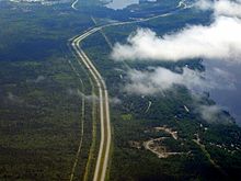 Highway 118, north of Dartmouth at the village of Waverley.
Highway 118, in Nova Scotia, is a short suburban freeway connecting (officially) Victoria Road via Woodland Ave. in Dartmouth with Highway 102 at Fall River, 14 kilometres (8.7 mi) to the north. The highway crosses the Historic Shubenacadie Canal. Running parallel to the highway from the Waverley Road to exit 14 is a portion of the Halifax Lateral of the Maritimes & Northeast Pipeline (natural gas). It also runs along the western shore of Lake Micmac and the western edge of Shubie Park and is known as Lakeview Drive. The highway serves as a "B-Train" route between Dartmouth and Highway 102. The highway has the only Collector-express section in Atlantic Canada. It is located at the new exit 12 Dartmouth Crossing interchange.
The south end of provincial maintenance is at the Highway 111 interchange.[2]
History
During the early 1970s, it was decided a new highway was required to directly link Highway 102 with Dartmouth. In 1972, the then Department of Highways expropriated a portion of land for the construction of Highway 118. The highway was completed in the late 1970's .
Exit list
The entire route is in the Halifax Regional Municipality.
Location km # Destinations Notes Coordinates Dartmouth 2 Micmac Boulevard, Lancaster Drive At-grade 44°41′8.4″N 63°34′9″W / 44.685667°N 63.56917°W 3 *11 
 Hwy 111 to Trunk 7 (Main Street) / Route 318 – Eastern Shore, Bedford, Halifax, Mackay Bridge
44°41′31.4″N 63°33′45.7″W / 44.692056°N 63.562694°W 5 *12 Wright Avenue - Dartmouth Crossing 44°42′26.9″N 63°33′26.2″W / 44.707472°N 63.557278°W 6 *13 Hwy 107 to Route 318 / Akerley Boulevard – Cole Harbour, Eastern Shore, Burnside Industrial ParkSigned as exits 13E (east) and 13W (west) 44°43′58.9″N 63°33′46.8″W / 44.733028°N 63.563°W Waverley 13 *14  To Trunk 2 / Route 318 – Fall River, Waverley, Wellington
Northbound exit and southbound entrance 44°48′13.2″N 63°36′1″W / 44.803667°N 63.60028°W Fall River 14 Hwy 102 north – Halifax International AirportNorthbound exit and southbound entrance 44°48′28.1″N 63°36′2″W / 44.807806°N 63.60056°W - Exit 1 was used from 1971 to 2007 and renumbered Exit 11
- Exits 2 and 3 used to be a work site until construction started on Dartmouth Crossing in 2005
- Exit 4 was used until 1979, when it was renumbered to Exit 13
- Exit 5 was also used until 1979, when it was renumbered to Exit 14
References
- ^ Halifax Regional Municipality Atlas ISBN 978-155109-641-4 ISBN 1-55109-641-2 Page 10"
- ^ Halifax Regional Municipality, By-Law No. T-400, as amended July 29, 2000
Roads and highways in Nova Scotia 100-series Trunk Routes Collector roads 201 · 202 · 203 · 204 · 205 · 206 · 207 · 208 · 209 · 210 · 211 · 212 · 213 · 214 · 215 · 216 · 217 · 219 · 221 · 223 · 224 · 236 · 239 · 242 · 245 · 246 · 247 · 252 · 253 · 255 · 256 · 276 · 277 · 289 · 301 · 302 · 303 · 304 · 305 · 306 · 307 · 308 · 309 · 311 · 312 · 316 · 318 · 320 · 321 · 322 · 324 · 325 · 326 · 327 · 328 · 329 · 330 · 331 · 332 · 333 · 334 · 335 · 336 · 337 · 340 · 341 · 344 · 347 · 348 · 349 · 354 · 357 · 358 · 359 · 360 · 362 · 366 · 368 · 374 · 376 · 395Scenic routes Coordinates: 44°42′32.35″N 63°33′22.81″W / 44.7089861°N 63.5563361°W
Categories:- Nova Scotia provincial highways
- Roads in the Halifax Regional Municipality
- Limited-access roads in Canada
- Nova Scotia road stubs


Wikimedia Foundation. 2010.