- Calvin Coolidge Bridge
Infobox Bridge
bridge_name=Calvin Coolidge Bridge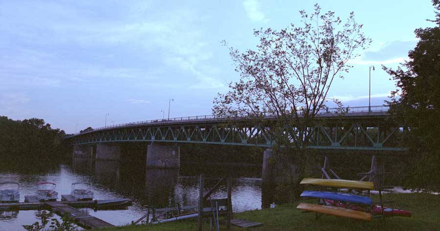
caption=
official_name=
carries=
crosses=Connecticut River
locale=Northampton, Massachusetts to
Hadley, Massachusetts
maint=Massachusetts Highway Department
id=
design=Warren deck truss
mainspan=
length=1,440.94 ft (439.2 m)
width=
height=
load=
clearance=
below=
traffic=34,900 [ [http://www.mhd.state.ma.us/default.asp?pgid=content/i91/i91&sid=about Exit 19 reconstruction] ]
begin=1936 [From the date range on the bridge's dedication plaque.]
complete=
open=October 12 1939 [ [http://select.nytimes.com/gst/abstract.html?res=FB071EFB3F5A177A93C1A8178BD95F4D8385F9 New York Times article] ]
closed=
toll=
map_cue=
map_
map_text=
map_width=
coordinates= coord|42|20|11|N|72|37|04|W|region:US_type:landmark|display=inline,title
lat=
long=The
Calvin Coolidge Memorial Bridge is a major crossing of theConnecticut River in WesternMassachusetts , connecting the towns of Northampton and Hadley. The bridge carries Route 9 across the river, where it connects toInterstate 91 . The bridge is a major bottleneck in Hampshire County—the only major hospital in the county, Cooley-Dickinson, is located in Northampton on the western side of the bridge. The road approaching the bridge is known as Bridge St. in Northampton (eastbound) and Russell St. in Hadley (westbound).History and construction of the bridge
The
Calvin Coolidge Memorial Bridge is a five-span, single intersection Warren deck truss bridge with distinctive design on its granite-faced abutment pylons.Art Deco ornamentation on the pylons includes carved eagles and incised carved lettering. The Bridge was funded under theHayden Cartwright Act , one of the numerous Federal aid programs designed to provide construction jobs during theGreat Depression . It was designed by W & L Engineering Co. in conjunction with Maurice A. Reidy as Consultant and Desmond and Lord as Architects. The Bridge was built by T. Stuart & Sons.The bridge was designed as memorial to President
Calvin Coolidge (1872-1933), a long time resident and former mayor of Northampton. Coolidge was elected to the State Senate and the governorship ofMassachusetts before being electedPresident of the United States . A bronze memorial plaque of Calvin Coolidge is mounted on the northeast and southwest pylons.The bridge features large, distinctive granite-faced pylons in the Art Deco style, measuring 15 by 27 feet at the base. On the northwest and southeast pylons are bronze doors that provide access to a small room reportedly used as posts for air raid wardens during
World War II .. These lamps were based on a European model and introduced to the U.S. market in 1933. However, the yellow/orange, monochromatic light produced by the luminaire ultimately became unpopular with the motoring public and use of the lamps was discontinued as color-corrected light sources became available.
In 2001, the Massachusetts Highway Department began a major improvement of the Coolidge Bridge, which included:
*Widening the Bridge from 3 lanes to 4 lanes, i.e., 2 travel lanes in each direction
*Replacement of the deteriorated bridge deck
*Refurbishing the historic Art Deco bridge railing and integrated light fixtures
*Cleaning and restoration of all granite facing
*Installation of a new 5-foot sidewalk on the north side of the Bridge
*Repairing and improving the Bridge approach roadwaysIn 2007 the Massachusetts Historical Commission determined that the Calvin Coolidge Bridge was not eligible for individual listing in the National Register of Historic Places but was eligible for listing as a contributing element in the (then) pending expansion of the Hadley Center Historic District. In 1994, the Bridge was included as a contributing element to the Hadley Center Historic District.
Previous bridge destroyed in the 1936 flood
There was at least one prior bridge on this site. [ [http://www.wgby.org/localprograms/flood/flood_gallery/pages/CoolidgeBridge.html Previous bridge is on top. Lower bridge is the one currently designated
Norwottuck Rail Trail Bridge ] ]See also
*
List of crossings of the Connecticut River External links
* [http://www.masstraveler.com/ Mass Traveler Western Massachusetts traffic info, including webcams of the Coolidge Bridge.]
References
Crossings navbox
structure = Crossings
place =Connecticut River
bridge = Calvin Coolidge Bridge
bridge signs =
upstream =Norwottuck Rail Trail Bridge
upstream signs =
downstream =Joseph E. Muller Bridge
downstream signs =
Wikimedia Foundation. 2010.