- Bykle
Infobox_Kommune
name = Bykle
idnumber = 0941
county = Aust-Agder
landscape = Setesdal
capital = Bykle
demonym = Byklar (N)
Bykler (B)
language =Nynorsk
munwebpage = www.bykle.kommune.no
governor = Kay Arne Jeiskelid (H)
governor_as_of = 2004
arearank = 55
area = 1467
arealand = 1262
areapercent = 0.45
population_as_of = 2008
populationrank = 410
population = 919
populationpercent = 0.02
populationdensity = 1
populationincrease = 10.2
lat_deg = 59 | lat_min = 26 | lat_sec = 35 | lon_deg = 7 | lon_min = 15 | lon_sec = 18
utm_zone = 32V | utm_northing = 6590701 | utm_easting = 0401056 | geo_cat = adm2ndBykle is a municipality in the county of
Aust-Agder ,Norway . It is located in the traditional region ofSetesdal . Bykle was separated from the municipality of Valle on 1 January 1902.General information
Name
The municipality (originally the
parish ) is named after the old "Bykle" farm (Old Norse : "Byklar"), since the first church was built there. The farm is named after the lakeBykil , but the meaning of that name is unknown.Coat-of-arms
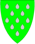
The coat-of-arms is from modern times. They were granted on 4 April 1986. The arms show
water droplets as a symbol for the water and rivers in the municipality, as well as for thehydropower plant which was founded in 1915. The plant has brought prosperity to the area since then. The green color of the background symbolizesagriculture . [cite web|url=http://www.ngw.nl/int/nor/b/bykle.htm|author=Norske Kommunevåpen|date=1990|title=Nye kommunevåbener i Norden|accessdaymonth=3 October|accessyear=2008] see also|Samnanger|TinnGeography
Bykle is bordered in the north by
Vinje municipality, in the east byTokke both inTelemark county. It is bordered in the south by Valle inAust-Agder county and also bordered bySirdal inVest-Agder county. It is bordered in the southwest byForsand and in the west byHjelmeland andSuldal --all inRogaland county.The Byklestigen pass is a torturous trail up a steep
cliff face. Until the 1870s, it was the only route to reach Bykle from the middleSetesdal valley to the south. It runs above the riverOtra and was the site of numerous accidents on the hazardous route.Economy
Bykle has several
hydroelectric power generation facilities.History
At "Storhedder" north of the lake "Storheddervatnet" prehistoric runic inscriptions dating over 1000 years old can be found.
The Hovden area was interconnected more with the districts to the west of the mountains than communities down the Setesdal valley. The main mountain plateau trade route led west to Suldal municipality in Rogaland. The Byklestigen pass was the line of divisions between dialects; in Valle to the south the classic Setesdal tongue was spoken while in Bykle the dialect includes a significant mixture from Telemark.
Falcon s were trapped in the heights above Bykle. From as early as 1203 and as late as 1780 there are reports of English and Dutch trapping of falcons at Breivik in Bykle. One byproduct of the numerous Dutch visits in the 1560s was the discovery that the natives had no natural resistance tosyphilis ; a state physician had to be dispatched there to stem the disease.It was split off from the older municipality of Valle on 1 January 1903 after a dispute over the costs of road building (Bykle was the bigger area, while Valle had more people and more money.) [cite book|title=South Norway|first=Frank Noel|last=Stagg|publisher=George Allen & Unwin, Ltd.|date=1958]
Attractions
* Bykle church, built in 1619, is found in Bykle center. It stands on the site of an older
stave church
* Open air museums at Huldreheimen and Lislestog.
* Hovdenski resort is found in the north.
*Viking era bog iron museum, which recognizes the industry in the area over 1000 years ago, located at Hovden
* Prehistoric runic inscriptions at Storhedderee also
*
Botsvatn References
External links
* [http://www.kulturnett.no/geografisknavigering/geografisknavigering_visning.jsp?fylke=T921062&kommune=T943666 Culture in Bykle on the map (Norwegian)]
Wikimedia Foundation. 2010.