- Wild Rice River (North Dakota)
Geobox River
name = Wild Rice River
native_name =
other_name =
other_name1 =

image_size = 300
image_caption = The Wild Rice River near Abercrombie in 2007
country = United States
state = North Dakota
region =
region1 =
district =
district1 =
city =
city1 =
length_imperial = 240
length_note = approx. [National Assessment Database. Sum of river segments, with section upstream of Wild Rice Creek estimated at ten miles per DeLorme and GNIS source coordinates, and total rounded to 240.]
watershed_imperial = 2233
watershed_note = [Red River of the North, Reconnaissance Report.]
discharge_location = near Abercrombie
discharge_imperial = 104
discharge_max_imperial = 9540
discharge_min_imperial = 0
discharge_note = Robinson, pp. 44-45]
discharge1_location = near Rutland
discharge1_imperial = 8.36
discharge1_note = Robinson, pp. 38-39]
source_name =
source_location = Brampton Township
source_district = Sargent County
source_region =
source_lat_d = 46
source_lat_m = 00
source_lat_s = 56
source_lat_NS = N
source_long_d = 97
source_long_m = 47
source_long_s = 08
source_long_EW = W
source_coordinates_note = Geographic Names Information System.]
source_elevation_imperial = 1283
source_elevation_note = Google Earth.]
mouth_name = Red River of the North
mouth_location = near Frontier
mouth_district = Cass County
mouth_region =
mouth_lat_d = 46
mouth_lat_m = 45
mouth_lat_s = 24
mouth_lat_NS = N
mouth_long_d = 96
mouth_long_m = 47
mouth_long_s = 24
mouth_long_EW = W
mouth_coordinates_note =
mouth_elevation_imperial = 879
mouth_elevation_note =
tributary_left =
tributary_left1 =
tributary_right =
tributary_right1 =
free_name =
free_value =
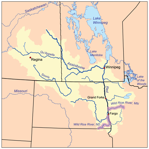
map_size = 300
map_caption = The Red River drainage basin, with the Wild Rice Rivers of North Dakota and Minnesota highlightedThe Wild Rice River is atributary of theRed River of the North , approximately 240 miles (390 km) long, in southeasternNorth Dakota in theUnited States . Via the Red River,Lake Winnipeg , and theNelson River , it is part of the watershed ofHudson Bay , draining an area of 2,233 square miles (5,783 km²) in theRed River Valley region. Its tributaries also drain a small part of northeasternSouth Dakota . Despite its length, it is a fairly small stream, flowing at an average rate of approximately 100cubic feet per second (3 m³/s).Course
The Wild Rice River rises as an intermittent stream in Brampton Township in southeastern Sargent County, approximately six miles (10 km) south of Cogswell. It initially flows generally eastwardly in a winding course through Sargent and Richland Counties, through the
Tewaukon National Wildlife Refuge and past the towns of Cayuga, Mantador and Great Bend. Past Great Bend, the river turns northward; from west of the city of Wahpeton it generally parallels the Red River in a winding channel at a distance of approximately three to seven miles (5-11 km). It flows into the Red River in southeastern Cass County, approximately three miles (5 km) southeast of Frontier and seven miles (11 km) south of Fargo. [North Dakota Atlas & Gazetteer, pp. 52-53, 63-64]Flow rate
The
United States Geological Survey operates astream gauge on the river 3.2 miles (5.2 km) northwest of Abercrombie. Between 1932 and 2005, the annual mean flow of the river at the gauge was 104cubic feet per second (3 m³/s). The river's highest flow during the period was 9,540 ft³/s (270 m³/s) onApril 11 ,1969 . Readings of zero have also been recorded.At an upstream gauge near Rutland in Sargent County, the annual mean flow between 1960 and 1982 was 8.36 ft³/s (0 m³/s). A reading of 2,700 ft³/s (76 m³/s) was recorded on
April 3 ,1997 .ee also
*
List of rivers in North Dakota References
Notes
ources
Books
*cite book| title= North Dakota Atlas & Gazetteer |year=1999 |publisher=
DeLorme |location=Yarmouth, Me. |isbn= 0-89933-343-5Websites
*cite web |url=Gnis3|1035247 |title=Geographic Names Information System entry for Wild Rice River (Feature ID #1035247) |publisher=
Geographic Names Information System |accessdate=2007-06-15
*cite web |url= http://iaspub.epa.gov/waters/w305b_report_control.get_report?p_state=ND |title= National Assessment Database: Assessment Data for the State of North Dakota Year 2004. |pages= [http://iaspub.epa.gov/tmdl/w305b_report_V4.huc?p_huc=09020105&p_state=ND Western Wild Rice Watershed] |publisher=United States Environmental Protection Agency |accessdate= 2007-06-15
*cite web |url=http://stinet.dtic.mil/oai/oai?&verb=getRecord&metadataPrefix=html&identifier=ADA140725 |title= Red River of the North, Reconnaissance Report: Wild Rice River |publisher= Defense Technical Information Center,United States Department of Defense |year=1980 |month=December |accessdate= 2007-06-15
*cite web |url=http://pubs.usgs.gov/wdr/2005/wdr-nd-05-1/pdf/wdrnd051.pdf |title=Water Resources Data North Dakota Water Year 2005, Volume 1 Surface Water. |first= S. M. |last=Robinson |coauthors=R. F. Lundgren, B. A. Sether, S. W. Norbeck, J. M. Lambrecht |publisher=United States Geological Survey |accessdate=2007-06-15oftware
*
Google Earth elevations forGeographic Names Information System coordinates. Retrieved on2007-06-15 .
Wikimedia Foundation. 2010.
Wild Rice River (North Dakota) — Wild Rice River Das Einzugsgebiet des Red River of the North, beide Wild Rice River sind hervorgehoben … Deutsch Wikipedia
Wild Rice River — ist der Name des Wild Rice River (Minnesota) in Minnesota des Wild Rice River (North Dakota) in North Dakota Diese Seite ist eine Begriffsklärung zur Unterscheidung mehrerer mit demselben Wort bezeichneter Begriffe … Deutsch Wikipedia
Wild Rice River — may refer to:*Wild Rice River (Minnesota) *Wild Rice River (North Dakota) … Wikipedia
Wild Rice River (Minnesota) — Wild Rice River Das Einzugsgebiet des Red River of the North, beide Wild Rice River sind hervorgehoben … Deutsch Wikipedia
North River, North Dakota — City Location of North River, North Dakota … Wikipedia
Wild Rice River (Minnesota) — The Wild Rice River is a tributary of the Red River of the North in northwestern Minnesota in the United States. It is 160 mi (257 km) long [http://reference.allrefer.com/gazetteer/W/W03220 wild rice river.html] . Via the Red River, Lake Winnipeg … Wikipedia
North Dakota — • One of the United States of America, originally included in the Louisiana Purchase. Catholic Encyclopedia. Kevin Knight. 2006. North Dakota North Dakota … Catholic encyclopedia
North Dakota — This article is about the U.S. state of North Dakota. For other uses, see North Dakota (disambiguation). State of North Dakota … Wikipedia
List of rivers of North Dakota — This is a list of rivers in the state of North Dakota in the United States.Alphabetically*Bois de Sioux River *Cannonball River *Cedar Creek *Cut Bank Creek *Deep River *Des Lacs River *Elm River, tributary of James River *Elm River, tributary of … Wikipedia
Liste der Flüsse in North Dakota — Dies ist eine Liste der Flüsse in North Dakota in den Vereinigten Staaten. Inhaltsverzeichnis 1 Alphabetisch 2 Nach Vorfluter 2.1 Missouri River 2.2 Red River of the North … Deutsch Wikipedia
Wild Rice River (North Dakota)
18+
© Academic, 2000-2024
- Contact us: Technical Support, Advertising
Dictionaries export, created on PHP, Joomla, Drupal, WordPress, MODx.