- Ophir Beach
-
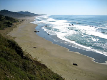
 Ophir Beach looking southward
Ophir Beach is an undeveloped sandy beach on the Oregon Coast seven miles north of Gold Beach in Curry County, United States.[1] It is more than 8.5 kilometres (5.3 mi) in length with the south end at Nesika Beach and the north end at a cape named the Devils Backbone.[2][3] The beach is bounded by U.S. Route 101 on the east. Euchre Creek flows westward to the ocean cutting through the northern third of the beach.[4]
There is a state maintained safety rest area at Ophir Beach with picnic tables and restrooms.[5]
This beach is sometimes referred to as Nesika Beach.[6]
References
- ^ "Ophir Beach". Geographic Names Information System, U.S. Geological Survey. http://geonames.usgs.gov/pls/gnispublic/f?p=gnispq:3:::NO::P3_FID:1154674. Retrieved 2009-05-04.
- ^ "Map of north end of Ophir Beach". Acme Mapper. http://mapper1.acme.com/save.cgi?lat=42.57719&long=-124.39251&scale=11&theme=Topo&width=3&height=2&dot=Yes. Retrieved 2009-04-10.
- ^ "Ophir Beach, United States". GeoNames. http://www.geonames.org/5744201/ophir-beach.html. Retrieved 2009-04-08.
- ^ "GeoNames". http://www.geonames.org/maps/google_42.55_-124.394.html. Retrieved 2009-04-10.
- ^ "Oregon Hiking". http://www.roguerivertrips.info/activities/Oregon_Hiking.asp. Retrieved 2009-04-08.
- ^ "Nesika Beach". http://www.goldbeachoregon.com/recreation/beaches/nesika-beach.html. Retrieved 2009-04-08.
Coordinates: 42°32′59″N 124°23′39″W / 42.54983°N 124.39427°W
Municipalities and communities of Curry County, Oregon Cities 
CDP Unincorporated
communitiesAgness | Carpenterville | Denmark | Illahe | Langlois | Marial | Nesika Beach | Ophir | Pistol River | Sixes | Wedderburn
Categories:- Beaches of Oregon
- Landforms of Curry County, Oregon

Wikimedia Foundation. 2010.