Oare Water

Oare Water
Oare Water
River
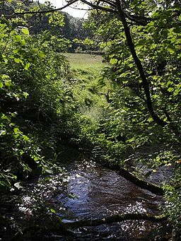
Country England
County Somerset
Source
 - coordinates 51°11′08″N 3°42′39″W / 51.18556°N 3.71083°W / 51.18556; -3.71083
Mouth East Lyn River
 - coordinates 51°13′05″N 3°43′42″W / 51.21806°N 3.72833°W / 51.21806; -3.72833

Oare Water passes through the village of Oare, on Exmoor in Somerset, England.

It joins Badgworthy Water before flowing to Watersmeet and the Bristol Channel,[1] as the East Lyn River.[2]

Oare bridge is an 18th century road bridge over Oare Water,[3]

References

  1. ^ "Oare Water". Walking Britain. http://www.walkingbritain.co.uk/walks/walks/walk_photo/126302/. Retrieved 2009-09-24. 
  2. ^ "Badgworthy Water". Everything Exmoor. http://everythingexmoor.org.uk/page.php?id=53. Retrieved 2009-09-24. 
  3. ^ "Oare bridge at NGR SS 8020". Images of England. English Heritage. http://www.imagesofengland.org.uk/Details/Default.aspx?id=265453. Retrieved 2009-02-01. 


Wikimedia Foundation. 2010.

Игры ⚽ Нужно сделать НИР?

Look at other dictionaries:

  • Oare, Somerset — Coordinates: 51°12′N 3°43′W / 51.20°N 3.71°W / 51.20; 03.71 …   Wikipedia

  • Oare Marshes — Oare Marshes: a birdwatching hide, on the seawall where Oare Creek joins The Swale. The Oare Marshes on the north coast of Kent to the north west of Faversham bordering The Swale. They include an internationally important nature reserve known… …   Wikipedia

  • Oare, Kent — Coordinates: 51°19′48″N 0°52′41″E / 51.330°N 0.878°E / 51.330; 0.878 …   Wikipedia

  • Minehead — For the Holiday Camp, see Butlins Minehead. Coordinates: 51°12′14″N 3°28′26″W / 51.2038°N 3.4738°W / 51.2038; 3.4738 …   Wikipedia

  • Dulverton — Coordinates: 51°02′44″N 3°32′57″W / 51.0455°N 3.5491°W / 51.0455; 3.5491 …   Wikipedia

  • Liste des cours d'eau d'Angleterre — Cet article présente une liste des cours d eau d Angleterre, classés par position géographique dans le sens inverse des aiguilles d une montre. Ils passent par l Angleterre et se jettent dans les mers qui bordent le pays. Pour l Esk, la Tweed, la …   Wikipédia en Français

  • Bath, Somerset — Coordinates: 51°23′N 2°22′W /  …   Wikipedia

  • Mendip Hills — Coordinates: 51°18′N 2°44′W / 51.3°N 2.733°W / 51.3; 2.733 …   Wikipedia

  • Chew Valley — This article is about Chew Valley in Somerset. For Chew Valley in Saddleworth, see Chew Valley, Greater Manchester. Not to be confused with Cheu Valley …   Wikipedia

  • South West Coast Path — The starting point at Minehead Length 630 miles (1,014 km) Location England: Somerset, Devon, Cornwall …   Wikipedia

Share the article and excerpts

Direct link
Do a right-click on the link above
and select “Copy Link”